Ashtabula County, Ohio facts for kids
Quick facts for kids
Ashtabula County
|
|||
|---|---|---|---|
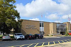
Ashtabula County Courthouse
|
|||
|
|||
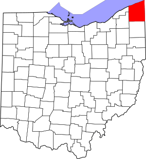
Location within the U.S. state of Ohio
|
|||
 Ohio's location within the U.S. |
|||
| Country | |||
| State | |||
| Founded | May 1, 1811 | ||
| Named for | Lenape ashtepihële 'always enough fish to go around' | ||
| Seat | Jefferson | ||
| Largest city | Ashtabula | ||
| Area | |||
| • Total | 1,368 sq mi (3,540 km2) | ||
| • Land | 702 sq mi (1,820 km2) | ||
| • Water | 666 sq mi (1,720 km2) 49%% | ||
| Population
(2020)
|
|||
| • Total | 97,574 |
||
| • Density | 71/sq mi (27/km2) | ||
| Time zone | UTC−5 (Eastern) | ||
| • Summer (DST) | UTC−4 (EDT) | ||
| Congressional district | 14th | ||
Ashtabula County (/ˌæʃtəˈbjuːlə/ ASH-tə-BYU-lə) is a county in the northeastern part of Ohio, a state in the United States. It is the county farthest northeast in Ohio.
In 2020, about 97,574 people lived here. The main town, called the county seat, is Jefferson. The biggest city in the county is Ashtabula.
Ashtabula County was started in 1808 and officially organized in 1811. Its name comes from the Lenape language. It means 'always enough fish to go around' or 'fish that can be given away'.
This county is famous for its many covered bridges. There are nineteen of them! It even has the longest and shortest covered bridges in the whole United States.
Grapes grow very well here because of the special weather near the lake. This means there are many award-winning wineries in the area. In winter, Ashtabula County gets a lot of lake-effect snow. This happens when cold air moves over the warmer Lake Erie.
Contents
History of Ashtabula County
When Europeans first arrived, the land that is now Ashtabula County was home to different Native American groups. The Erie people lived in the eastern part. They were similar to the Iroquois, living in longhouses and palisaded villages. In the west, the Whittlesey culture lived. They were likely Algonquian people.
Both the Erie and Whittlesey tribes probably disappeared during the Beaver Wars. These wars happened in the 1600s between different Native American tribes, often over land and trade. Later, the French explored the Great Lakes by ship.
The land became part of the French colony called Illinois Country. In 1764, after a war, France gave this land to Great Britain. It became part of the Province of Quebec.
Later, a group called the Wyandot lived in the area. They used much of the land as a shared hunting ground. Other tribes like the Seneca, Shawnee, Lenape, and Ottawa also used it.
After the Northwest Indian War in the 1790s, the Native Americans gave ownership of the land to the United States. This was done through the Treaty of Greenville. Some Ottawa people stayed in the area for about 30 more years.
In the late 1700s, this land became part of the Connecticut Western Reserve. This was a piece of land in the Northwest Territory claimed by Connecticut. The Connecticut Land Company bought it in 1795. This led to the first American settlers moving into the region.
Before the American Civil War, Ashtabula County was a strong center for people who were against slavery. John Brown's son, John Jr., lived here. His brother Owen also found safety in the county. Many people in the area helped those escaping slavery.
Geography of Ashtabula County
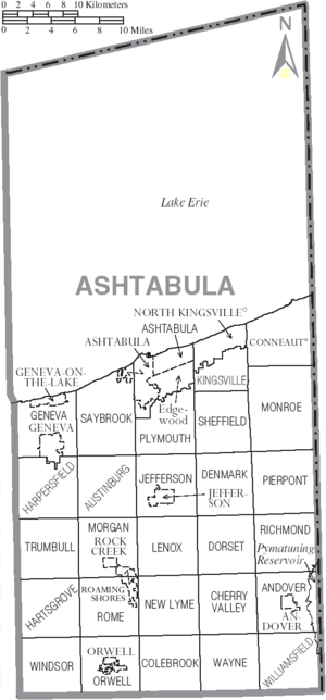
Ashtabula County covers a total area of about 1,368 square miles. About 702 square miles of this is land, and 666 square miles (49%) is water. This makes it the largest county in Ohio by total area.
Neighboring Areas
Across Lake Erie to the north are Elgin and Norfolk Counties in Ontario, Canada.
- Erie County, Pennsylvania (northeast)
- Crawford County, Pennsylvania (east)
- Trumbull County (south)
- Geauga County (southwest)
- Lake County (west)
Main Roads
 I-90
I-90 US 6
US 6 US 20
US 20 US 322
 SR 7
SR 7 SR 11
SR 11 SR 45
SR 45 SR 46
SR 46 SR 84
SR 84 SR 85
SR 85 SR 86
SR 86 SR 167
 SR 193
 SR 307
 SR 531
 SR 534
People of Ashtabula County
| Historical population | |||
|---|---|---|---|
| Census | Pop. | %± | |
| 1820 | 7,382 | — | |
| 1830 | 14,584 | 97.6% | |
| 1840 | 23,724 | 62.7% | |
| 1850 | 28,767 | 21.3% | |
| 1860 | 31,814 | 10.6% | |
| 1870 | 32,517 | 2.2% | |
| 1880 | 37,139 | 14.2% | |
| 1890 | 43,655 | 17.5% | |
| 1900 | 51,448 | 17.9% | |
| 1910 | 59,547 | 15.7% | |
| 1920 | 65,545 | 10.1% | |
| 1930 | 68,631 | 4.7% | |
| 1940 | 68,674 | 0.1% | |
| 1950 | 78,695 | 14.6% | |
| 1960 | 93,067 | 18.3% | |
| 1970 | 98,237 | 5.6% | |
| 1980 | 104,215 | 6.1% | |
| 1990 | 99,821 | −4.2% | |
| 2000 | 102,728 | 2.9% | |
| 2010 | 101,497 | −1.2% | |
| 2020 | 97,574 | −3.9% | |
| U.S. Decennial Census 1790–1960 1900–1990 1990–2000 2020 |
|||
Census Information (2010)
In 2010, there were 101,497 people living in Ashtabula County. There were 39,363 households and 26,495 families. The population density was about 144.6 people per square mile.
Most people (92.7%) were white. About 3.5% were Black or African American. People of Hispanic or Latino origin made up 3.4% of the population.
The main backgrounds of people included German (24.9%), Irish (15.8%), English (12.6%), and Italian (11.1%).
About 31.3% of households had children under 18 living with them. The average age of people in the county was 41 years old.
Culture of Ashtabula County
Ashtabula County has a large community of Finnish Americans. This is because many people from Finland settled here around the early 1900s.
The county is also famous for its eighteen covered bridges. Nine of these bridges were built before the year 1900. You can find a list of them at List of Ashtabula County covered bridges.
Communities in Ashtabula County
Cities
Villages
- Andover
- Geneva-on-the-Lake
- Jefferson (county seat)
- North Kingsville
- Orwell
- Roaming Shores
- Rock Creek
Townships
- Andover
- Ashtabula
- Austinburg
- Cherry Valley
- Colebrook
- Conneaut
- Denmark
- Dorset
- Geneva
- Harpersfield
- Hartsgrove
- Jefferson
- Kingsville
- Lenox
- Monroe
- Morgan
- New Lyme
- Orwell
- Pierpont
- Plymouth
- Richmond
- Rome
- Saybrook
- Sheffield
- Trumbull
- Wayne
- Williamsfield
- Windsor
Census-designated places
- Austinburg
- Edgewood
- Kingsville
- Saybrook-on-the-Lake
Unincorporated communities
Notable People from Ashtabula County
- Chester H. Aldrich (1862–1924), a former governor of Nebraska.
- Brian Anderson, a pitcher for the Cleveland Indians.
- John Brown Junior (1821–1895), son of the famous abolitionist John Brown.
- Charles Case (1817–1883), a U.S. congressman from Indiana.
- Tammy Cochran, a country music singer.
- Edwin Cowles (1825–1890), a newspaper publisher.
- Charles DeBarber, a cyber intelligence analyst.
- Joshua Reed Giddings (1795–1864), a U.S. House of Representatives member who opposed slavery.
- Rosetta Luce Gilchrist (1850-1921), a physician and writer.
- Francis Joseph Hall, an American theologian and author.
- Ken Meyer, a former head coach for the San Francisco 49ers football team.
- Urban Meyer, a successful college football coach for teams like the University of Florida and The Ohio State University.
- James Montgomery, (1814–1871), a colonel during the American Civil War.
- Dangerfield Newby (c. 1820–1859), a freed slave involved in John Brown's raid.
- Danielle Nicolet, a television, film, and voice actress.
- Larry Obhof, a former President of the Ohio Senate.
- Ransom Eli Olds, a pioneer in the American automobile industry.
- Glenn W. Salisbury, an agricultural scientist.
- Louis C. Shepard, a Medal of Honor recipient from the Civil War.
- Decius Wade, a lawyer and judge known as the "Father of Montana Jurisprudence."
- Clarence Darrow, a famous American lawyer.
- Connie Schultz, a writer and journalist.
- Doug Tompkins, co-founder of The North Face and Esprit.
See also
 In Spanish: Condado de Ashtabula para niños
 | Bayard Rustin |
 | Jeannette Carter |
 | Jeremiah A. Brown |


