Lake County, Ohio facts for kids
Quick facts for kids
Lake County
|
|||||
|---|---|---|---|---|---|
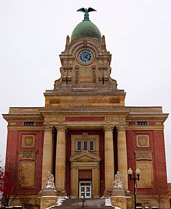
Lake County Courthouse
|
|||||
|
|||||
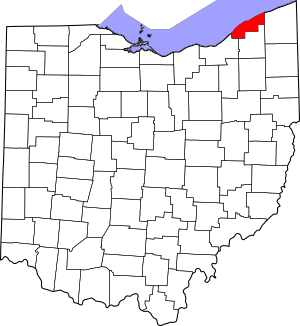
Location within the U.S. state of Ohio
|
|||||
 Ohio's location within the U.S. |
|||||
| Country | |||||
| State | |||||
| Founded | March 6, 1840 | ||||
| Named for | Lake Erie | ||||
| Seat | Painesville | ||||
| Largest city | Mentor | ||||
| Area | |||||
| • Total | 979 sq mi (2,540 km2) | ||||
| • Land | 227 sq mi (590 km2) | ||||
| • Water | 752 sq mi (1,950 km2) 77% | ||||
| Population
(2020)
|
|||||
| • Total | 232,603 | ||||
| • Estimate
(2021)
|
232,023 |
||||
| • Density | 237.59/sq mi (91.73/km2) | ||||
| Time zone | UTC−5 (Eastern) | ||||
| • Summer (DST) | UTC−4 (EDT) | ||||
| Congressional district | 14th | ||||
Lake County is a county in the U.S. state of Ohio. As of the 2020 census, about 232,603 people lived there. Its main town, called the county seat, is Painesville. The biggest city in Lake County is Mentor.
The county was created on March 6, 1840. It was formed from parts of Cuyahoga and Geauga counties. Lake County got its name because it's located right on the southern shore of Lake Erie. A large part of the county's total area is actually under Lake Erie. Lake County is also part of the larger Cleveland Metropolitan Area.
Contents
History
Long ago, the land that is now Lake County was home to the Erie people. This was before the French arrived in the early 1600s. The French considered this area part of their colony, New France.
In 1763, the land was given to Great Britain. It became part of the Province of Quebec in 1774. After the American Revolutionary War, it became part of the Connecticut Western Reserve in the Northwest Territory. The Connecticut Land Company bought it in 1795. Finally, in March 1840, Lake County was officially separated from Geauga County.
Geography
Lake County covers a total area of 979 square miles (2,540 km2). Out of this, 227 square miles (590 km2) is land, and 752 square miles (1,950 km2) (which is 77%) is water. This makes it Ohio's smallest county by land area. However, it's the third-largest by total area because of the land it owns under Lake Erie.
The county has a 31-mile long coastline along Lake Erie. Lake County also shares an international border with Ontario, Canada, across Lake Erie.
Neighboring Counties
- Ashtabula County (east)
- Geauga County (south)
- Cuyahoga County (southwest)
Main Roads
 I-90
I-90 I-271
I-271 US 6
US 6 US 20
US 20 SR 2
SR 2 SR 44
SR 44 SR 84
SR 84 SR 86
SR 86 SR 91
SR 91 SR 174
 SR 283
 SR 306
 SR 307
 SR 528
 SR 535
 SR 608
 SR 615
 SR 633
 SR 640
Protected Areas
Population Information
| Historical population | |||
|---|---|---|---|
| Census | Pop. | %± | |
| 1840 | 13,719 | — | |
| 1850 | 14,654 | 6.8% | |
| 1860 | 15,576 | 6.3% | |
| 1870 | 15,935 | 2.3% | |
| 1880 | 16,326 | 2.5% | |
| 1890 | 18,235 | 11.7% | |
| 1900 | 21,680 | 18.9% | |
| 1910 | 22,927 | 5.8% | |
| 1920 | 28,667 | 25.0% | |
| 1930 | 41,674 | 45.4% | |
| 1940 | 50,020 | 20.0% | |
| 1950 | 75,979 | 51.9% | |
| 1960 | 148,700 | 95.7% | |
| 1970 | 197,200 | 32.6% | |
| 1980 | 212,801 | 7.9% | |
| 1990 | 215,499 | 1.3% | |
| 2000 | 227,511 | 5.6% | |
| 2010 | 230,041 | 1.1% | |
| 2020 | 232,603 | 1.1% | |
| 2021 (est.) | 232,023 | 0.9% | |
| U.S. Decennial Census 1790-1960 1900-1990 1990-2000 2010-2020 |
|||
In 2010, most people (92.4%) in Lake County spoke English. About 2.7% spoke Spanish, and 1.4% spoke Croatian.
2010 Census Details
In 2010, there were 230,041 people living in Lake County. There were 94,156 households and 62,384 families. The population density was about 1,011.2 inhabitants per square mile (390.4/km2).
Most people in the county (92.5%) were white. Other groups included 3.2% black or African American, 1.1% Asian, and 0.1% American Indian. About 3.4% of the population was of Hispanic or Latino origin.
The average household had 2.41 people, and the average family had 2.97 people. The average age of people in the county was 42.3 years.
Environment
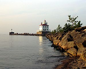
Lake County has a large system of public parks. These include the Lake Metroparks Farmpark. Kirtland is home to the Holden Arboretum and Gildersleeve Mountain. Headlands Beach State Park is located in Mentor. The Grand River and the Chagrin River are both recognized as state scenic rivers.
Transportation
Laketran is the public transportation service in Lake County. Interstate 90 runs through the county, going northeast to southwest. It runs roughly next to State Route 2. State Route 44 connects these two roads, running north to south. These highways are the main routes for traffic in the county.
Lake County does not have passenger train service. However, Amtrak's "Lake Shore Limited" train passes through the county nightly. It stops in Cleveland and Erie. Freight trains also use the main railway lines here.
Library Services
Many libraries serve the people of Lake County:
- Fairport Harbor Public Library in Fairport Harbor
- Kirtland Public Library in Kirtland
- Madison Public Library in Madison
- Mentor Public Library in Mentor
- Morley Library in Painesville
- Perry Public Library in Perry
- Wickliffe Public Library in Wickliffe. This library is known as a "Top Ten American Library." In 2005, it loaned out over 459,000 items.
- Willoughby-Eastlake Public Library, with its main office in Eastlake. It has branches in Eastlake, Willoughby, Willoughby Hills, and Willowick. In 2005, this library loaned over 1.2 million items.
All Lake County libraries became members of CLEVNET in 2019. This means they share resources with many other libraries.
Communities
Cities
Villages
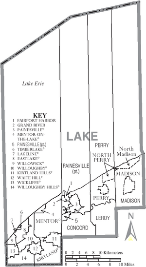
Townships
- Concord
- Leroy
- Madison
- Painesville
- Perry
Census-designated place
Unincorporated communities
See also
 In Spanish: Condado de Lake (Ohio) para niños
 | Jewel Prestage |
 | Ella Baker |
 | Fannie Lou Hamer |


