Grand River (Ohio) facts for kids
Quick facts for kids Grand River |
|
|---|---|

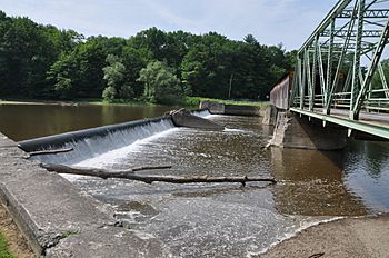
Harpersfield Covered Bridge over the Grand River
|
|
|
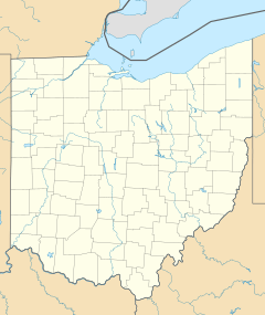
Location of the mouth within Ohio
|
|
| Country | United States |
| State | Ohio |
| Counties | Geauga, Trumbull, Ashtabula, Lake |
| Physical characteristics | |
| Main source | Geauga County 41°24′50″N 81°04′40″W / 41.4139435°N 81.0778745°W |
| River mouth | Lake Erie Fairport Harbor 41°45′37″N 81°16′50″W / 41.7603208°N 81.2806588°W |
| Length | 102.7 mi (165.3 km) |
| Basin features | |
| Basin size | 712 sq mi (1,840 km2) |
The Grand River is a river in northeastern Ohio, United States. It flows for about 102.7 miles (165.3 km). This river is a tributary of Lake Erie.
The Grand River eventually flows into Lake Erie. From there, its waters travel through the Niagara River and Lake Ontario. Finally, they reach the St. Lawrence River, which empties into the Atlantic Ocean. The river collects water from a large area of about 712 square miles (1844 km²).
The Grand River starts in southeastern Geauga County. It first flows east into Trumbull County. After West Farmington, it turns north into Ashtabula County.
In Ashtabula County, it flows through the village of Rock Creek. Then, it turns west into Lake County. Here, it passes through Painesville and Grand River. The river finally flows into Lake Erie at Fairport Harbor.
Contents
Understanding the Grand River's Path
The Grand River is special because of its unique path and natural beauty. It has been recognized for its importance.
Ohio's Wild and Scenic River
On January 17, 1974, the Grand River became Ohio's second wild and scenic river. This means parts of the river are protected. The "wild" section is 23 miles long. It runs from the Harpersfield covered bridge downstream towards Painesville.
The "scenic" section is 33 miles long. It goes from US 322 in Ashtabula County to the Harpersfield covered bridge. These protections help keep the river natural.
How Glaciers Shaped the River
During the Ice Age, a large glacier called the Wisconsinan glacier covered Ohio. A part of this glacier, known as the Grand River lobe, moved across northeastern Ohio. It was stopped by strong sandstone hills in the south.
This glacier helped create the rugged landscape around the Grand River. This landscape makes the river a great example of a natural stream in Ohio.
Wildlife and Nature Along the River
The upper part of the Grand River in Ashtabula County is a scenic area. Many parts of the river are surrounded by swamp forests. These forests have trees like elm, ash, maple, and oak.
The slow flow of this river section and its wetlands create a great home for wildlife. River otters, for example, have returned to the area. They were brought back by the Division of Wildlife in 1986 and 1988.
The lower part of the Grand River in Lake County is a wild section. Here, the river flows through deep valleys with steep walls. These walls are made of Chagrin Shale.
When it rains, waterfalls flow over these steep shale cliffs. This creates a spectacular view. Protecting the river means also protecting the land around it.
Protecting the Grand River's Future
Activities like building new homes can affect the river. It is important to manage land use in the river's watershed. This helps protect this important Ohio water resource for the future.
The Grand River has the most types of water animals and plants of any Ohio river that flows into Lake Erie. Many groups work together to help preserve the river.
The 2006 Flood Event
On July 28, 2006, the Grand River had a very big flood. The river overflowed its banks. This caused a state of emergency in Lake County and Ashtabula County.
The river rose 11 feet above its normal flood level. This was considered a "500-year flood." It happened because of a huge amount of rain over 48 hours. This amount of rain was a "1,000-year rain."
The flood was so strong that it changed the path of one of its smaller streams, Paine Creek. The area was later declared a Federal Disaster area.
Grand River History
The first settlers of the Western Reserve arrived at Fairport Harbor. This was before they traveled overland to new settlements. One such settlement was Burton.
Other Names for the Grand River
The Grand River has been known by several other names throughout history. These names include:
- Grande Riviere
- Chereage River
- Chocago River
- Chogage River
- Geauga River
- Geaugah River
- Riviere Charage
- Sheauga River
Grand River Tributaries
The Grand River has several smaller rivers and streams that flow into it. These are called tributaries. The longest tributaries are:
- Mill Creek, which is about 28.8 miles (46.3 km) long.
- Rock Creek, which is about 18.4 miles (29.6 km) long.
- Big Creek, which is about 15.6 miles (25.1 km) long.
 | Stephanie Wilson |
 | Charles Bolden |
 | Ronald McNair |
 | Frederick D. Gregory |


