
Chagrin River facts for kids
Quick facts for kids Chagrin River |
|
|---|---|

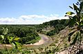
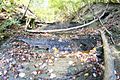
Chagrin River from South Chagrin Reservation
|
|
| Country | United States |
| State | Ohio |
| Physical characteristics | |
| Main source | Bass Lake, Ohio Munson Township, Northeast Ohio |
| River mouth | Chagrin Harbor Eastlake, Lake County, OH 41°40′36″N 81°26′13″W / 41.67667°N 81.43694°W |
The Chagrin River is a cool river in Northeast Ohio. It has two main parts, like two arms reaching out: the Aurora Branch and the East Branch. People think its name might come from a French person named Sieur de Seguin. He had a trading post near the river around 1742.
The Chagrin River flows through towns near Greater Cleveland. It goes through Cuyahoga, Geauga, and Portage counties. It also winds through two Cleveland Metroparks areas. Finally, it empties into Lake Erie in Lake County. In 1979, the Chagrin River was named a state scenic river. This means it's a special place to protect.
The East Branch starts in Geauga County. It flows north and then west through Lake County. This includes towns like Kirtland and Kirtland Hills. This branch also flows through the Holden Arboretum, a big garden and forest. It then joins the main river in Willoughby.
The Aurora Branch begins in the northwest part of Portage County. It flows northwest through Aurora. It also passes through parts of Geauga and Cuyahoga Counties. This branch meets the main river west of Chagrin Falls.
Contents
Exploring the River's Natural History
The Chagrin River area is full of interesting rocks. You can see layers of different types of bedrock along its banks. These include Berea sandstone, Bedford shale, Cleveland Shale, and Chagrin Shale. The river itself was carved out by huge glaciers. This happened when the glaciers melted away after the last ice age.
Chagrin Shale: The Deepest Layer
The lowest rock layer you can see is called Chagrin shale. It's named after the river itself. This shale is blue-gray and was formed from silt a long, long time ago. It's from the Devonian period, which was millions of years ago. You can find this layer deep in the river valley.
Cleveland Shale: A Fossil Hotspot
Above the Chagrin shale is the Cleveland shale. This rock is black and is a great place to find fossils. Many ancient plants and animals are preserved here. The Cleveland Shale is found higher up in the Chagrin River valley.
Bedford Shale: A Unique Rock
Next comes the Bedford Shale. This layer shows a time when the Earth was changing. It's also a good spot for finding more fossils. You can find Bedford shale in the smaller valleys that feed into the Chagrin River. This shale is sandy and breaks into cool, almost square pieces. It looks like someone cut them by hand!
Berea Sandstone: A Building Block
The Berea sandstone is found even higher up. This sandstone is a very important building material in the area. In the 1800s, people dug it out from a place called Gildersleeve Mountain. This stone was used to build famous buildings like the Kirtland Temple. Even today, Berea sandstone is used for building things locally.
River Life: Fish and Birds
The Ohio Department of Natural Resources says the Chagrin River is home to many animals. More than 49 types of fish live in its watershed. Also, over 90 kinds of birds can be found here. One special fish is the American brook lamprey. This fish is quite rare in Ohio, but it lives in the Chagrin River.
Fun Activities and Recreation
The Chagrin River is a great place for outdoor fun!
Hiking and Fishing Adventures
Many people love to go hiking along the river's paths. Fishing is also very popular here. ESPN Outdoors even suggests the Chagrin River for fishing. It's especially good for catching steelhead fish. A favorite fishing spot used to be near the Daniels Park Dam. However, this small dam broke on December 31, 2004. It gave way because of too much ice and water pressure.
Whitewater Rafting Fun
If you like adventure, parts of the Chagrin River are great for whitewater activities. The Aurora branch of the river has exciting rapids. These are rated as "class III-IV," which means they are quite challenging. But the Daniels Park section is much calmer, rated as a "class I." This means it's easy and good for beginners.
Protecting the River's Flow
In 2007, a part of the East Branch of the river was changed. About 8,700 feet (2,650 meters) of the river was made straight and had walls built along it. This was done to try and stop flooding on nearby farmland. However, these changes were not allowed.
Changing the river like this caused problems. It harmed the natural areas along the river. It also made flooding worse for towns downstream, like Willoughby and Eastlake. As of September 2007, people were working on a plan. The goal was to return the East Branch to its natural condition.
Images for kids
-
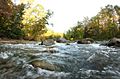
Viewed from Hach-Otis Sanctuary (Willoughby Hills, Ohio)
-
Viewed from Cleveland Metropolitan Park (Willoughby Hills, Ohio)
-
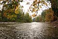
Viewed in fall, from Cleveland Metropolitan Park (Willoughby Hills, Ohio)
-
Viewed in fall, from Willoughby Hills, Ohio
-
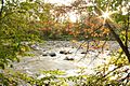
A minor tributary flowing into the Chagrin River, viewed from Cleveland Metropolitan Park
.jpg)


