
Bedford Shale facts for kids
Quick facts for kids Bedford ShaleStratigraphic range: Late Famennian |
|
|---|---|

Bedford Shale at Brandywine Falls on Brandywine Creek near Boston Heights, Ohio
|
|
| Type | Formation |
| Unit of | Waverly Group |
| Underlies | Berea Sandstone |
| Overlies | Cussewago Sandstone, Cleveland Shale, and Ohio Shale |
| Location | |
| Country | United States |
| Type section | |
| Named for | Bedford, Ohio, U.S. |
The Bedford Shale is a type of shale rock found in several states across the United States. These states include Ohio, Michigan, Pennsylvania, Kentucky, West Virginia, and Virginia. It's a "geologic formation," which means it's a distinct layer of rock that geologists can identify and map.
Contents
What is the Bedford Shale?
How it was Discovered and Named
The Bedford Shale was first identified in 1870 by John Strong Newberry. He was the director of the Ohio State Geological Survey. He named it after Bedford, Ohio, where he found a good example of this rock layer. This spot, near Tinkers Creek, is called its "type locality." A type locality is the specific place where a rock formation was first described.
What the Rock Looks Like
In northern Ohio, the Bedford Shale is mostly a soft, red clay shale. Near its bottom, it can be grayish-black. Sometimes, you can find thin layers of siltstone within it. These siltstone layers can be about 3 inches (7.6 cm) thick. They often show ripple marks, like those left by water.
As you move east from Lorain County, Ohio, the amount of silt in the rock increases. Near the Cuyahoga River, the Bedford Shale changes quite a bit. It becomes a mix of red and gray shale. The bottom 12 feet (3.7 m) of the rock turns into a hard siltstone. This part is known as the Euclid member.
Further east, near the Grand River, the clay shale is replaced by silty gray shale. You'll also find hard, silty gray mudstone and thin, flat gray siltstone.
Changes in Color and Texture
The red color of the shale becomes less strong and thinner as you go south in Ohio. South of Columbus, it's just a few feet thick and reddish-brown. Most of the Bedford Shale in southern Ohio is bluish-gray. In areas like Ross and Pike counties, the rock changes from a soft clay shale to a gray silty shale. It has thin layers of gray siltstone in its upper parts.
Throughout Ohio, you can find thin layers of siltstone in all types of Bedford Shale. These layers are often rich in calcium and are about 2 to 4 inches (5.1 to 10.2 cm) thick. In southern Ohio, these siltstone layers become more common and thicker in the upper part of the Bedford Shale.
Sometimes, you can see "flow rolls" in the bottom part of the Bedford Shale. These are places where the rock has been greatly twisted and rolled into a cylinder shape.
Bedford Shale in Other States
In Michigan, the Bedford Shale is light gray or bluish-light gray. It's a silty shale, meaning it contains a lot of fine sand-like particles. The top part is even sandier.
In Kentucky, the Bedford Shale is gray or greenish-gray. It has thin layers of siltstone and round lumps called concretions. These concretions can contain pyrite, also known as "fool's gold." Some areas in Boyd County, Kentucky, have red Bedford Shale.
Where is the Bedford Shale Found?

The Bedford Shale is found across a wide area in the eastern United States.
Ohio
The Bedford Shale has been studied a lot in Ohio. It can be seen along Lake Erie, from the Ohio-Pennsylvania border west to Lorain County. It then runs south to Lawrence County. The Ohio River forms its southernmost boundary in the state.
The Bedford Shale in Ohio is usually about 85 to 95 feet (26 to 29 m) thick. It's thickest, about 150 feet (46 m), between Lorain and Licking counties. The thickness can vary because of erosion from ancient rivers and glaciers. It gets thinner as you go south and east.
You can see the Bedford Shale in places like Cuyahoga, Lake, and Geauga counties. It's often found in cliffs below another rock layer called the Berea Sandstone. In other areas, it's often covered by soil or glacial deposits.
Michigan

In Michigan, the Bedford Shale is found in the southeast, along the shores of Lake Erie and Lake St. Clair. It's also found along Lake Huron and Lake Michigan.
The Bedford Shale in Michigan is generally about 60 feet (18 m) thick. In some areas, it can be almost 250 feet (76 m) thick. It gets finer and thinner as you move west towards the center of the Michigan Basin.
You can't usually see the Bedford Shale on the surface in Michigan. It's covered by thick layers of sand, gravel, and clay left behind by glaciers.
Kentucky
The Bedford Shale is found throughout much of eastern Kentucky. It's thickest in the north, in Lewis County. It gets thinner and eventually disappears as you go south and west. It can be about 100 feet (30 m) thick in Letcher and Pike counties.
In Kentucky, the Bedford Shale is often covered by thin soil and weathered sandstone. You might see it along the Pine Mountain ridge in Harlan County.
Pennsylvania
In Pennsylvania, the Bedford Shale is found in Crawford County. It's also called "Hayfield limestone" there. It's usually gray to bluish-gray and often has ripple-marked siltstone layers. It's about 44 feet (13 m) thick in some places but can be much thinner.
West Virginia and Virginia
The Bedford Shale has also been found underground in West Virginia, especially along the Ohio River. It's hard to tell exactly where it ends because it looks very similar to other older rocks. It has also been identified in southwestern Virginia.
How it Relates to Other Rocks
Layers of Rock
The Bedford Shale is the lowest layer of a larger group of rocks called the Waverly Group. Above the Bedford Shale, you'll find the Berea Sandstone, then the Sunbury Shale, and other layers.
In Ohio, the Bedford Shale usually sits on top of the Cleveland Shale. Sometimes, there's a small "transition zone" between them. This zone can be a few inches to about 4.2 feet (1.3 m) thick. The boundary between the Bedford and Cleveland shales is usually clear. However, it's very hard to tell the difference between the Bedford Shale and the Chagrin Shale because they look so similar.
What's Above It?
Generally, the Berea Sandstone sits on top of the Bedford Shale in Ohio. The line where these two rocks meet is usually clear but can be very uneven. This is because rivers and erosion carved deep channels into the Bedford Shale before the sand that became the Berea Sandstone was laid down. For example, near Berea, Ohio, channels as deep as 85 feet (26 m) were cut into the Bedford Shale.
In Michigan, the Bedford Shale is also usually covered by the Berea Sandstone. The top part of the Bedford is silty and sandy, making it hard to see the exact boundary. In eastern Michigan, the Bedford Shale sits on top of the Antrim Shale.
In Kentucky, the Bedford Shale is usually found on top of the Ohio Shale and below the Berea Sandstone. The top and bottom contacts are usually clear. In some parts of eastern Kentucky, the Bedford Shale and Berea Sandstone "intertongue," meaning they mix together in interlocking layers.
Ancient Life in the Shale
Except for its very bottom layers, the Bedford Shale doesn't have many fossils.
In central and north-central Ohio, the lowest few feet of the Bedford Shale contain many fossils. These include ancient sea creatures like brachiopods (shellfish), molluscs (like clams), and fish from the Devonian Period. South of Ross County, many siltstones in the Bedford Shale show "fucoids." These are fossilized casts of ancient seaweed.
The bottom 1 to 5 feet (0.3 to 1.5 m) of the Bedford Shale in Michigan also have many fossils from the Famennian stage. Small amounts of natural gas have also been found in the shale here.
In northeast Kentucky, invertebrate fossils (animals without backbones) are found at the top of the transition zone in the Bedford Shale.
How Old is the Bedford Shale?
The Bedford Shale was formed during the very end of the Famennian stage of the Devonian Period. This means the rock is about 365 to 358.9 million years old.
Scientists have studied the age of the Bedford Shale for a long time. Some thought it was older, and some thought it was younger. But the most recent evidence shows it belongs to the upper Devonian Period. This was confirmed by studying tiny fossils like conodonts and spores found in the rock.
What Was it Used For?
Native Americans used the weathered Bedford Shale for its reddish color. They used it as a pigment, like paint. Early French traders even named the Vermillion River after the red color of the Bedford Shale found there.
In the 1800s and early 1900s, weathered Bedford Shale was used to make bricks and tiles. These "face bricks" were used on the outside of buildings to make them look nice.
Images for kids
-
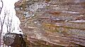
Bedford Shale at Brandywine Falls on Brandywine Creek near Boston Heights, Ohio
-
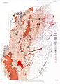
Map showing general location of the Bedford Shale in Ohio, northeastern Kentucky, and western Pennsylvania.
-
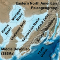
Eastern North America in the Middle Devonian, showing the Michigan Basin of the Rheic Ocean.
