
Mid-Atlantic States facts for kids

The Mid-Atlantic States are a group of states in the United States. They are also known as the Middle Atlantic States. These states are part of one of the nine official geographic areas in the U.S. The United States Census Bureau recognizes these divisions.
The Mid-Atlantic region officially includes three states: New Jersey, New York, and Pennsylvania. This area is on the Atlantic Seaboard. It sits between the New England states and the Southern states. Some people also think of Delaware and Maryland as part of the Mid-Atlantic. These states are south of the Northeast.
A Busy Region
The Mid-Atlantic States are very important. They are the most crowded of the nine U.S. regions. This area is home to a huge urban stretch called a megalopolis. This long chain of cities goes from Boston in the north to Washington, D.C. in the south.
Major Cities and Areas
The southeastern part of New York State, eastern Pennsylvania, and all of New Jersey are very busy. This area forms a large part of what some experts call the "Metropolis." This "Metropolis" starts near New York City in southern Connecticut. It then stretches along the Eastern seaboard to northern Virginia, near Washington, D.C..
Some parts of New York State and Pennsylvania are also known as the Rust Belt. This term refers to areas that used to have many factories.
Images for kids
-

Shipping containers at the Port Newark–Elizabeth Marine Terminal in New Jersey.
-
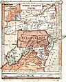
An 1897 map showing the Mid-Atlantic region.
-
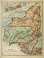
An 1886 map from "Harper's School Geography" showing the region.


See also
 In Spanish: Atlántico Medio de Estados Unidos para niños
