Pembina Region facts for kids
Quick facts for kids Pembina Region |
|||||||||||||||||
|---|---|---|---|---|---|---|---|---|---|---|---|---|---|---|---|---|---|
| Unorganized territory of United States | |||||||||||||||||
| 1818–1889 | |||||||||||||||||
 |
|||||||||||||||||
| Capital | Washington DC (1818–1849) Bismarck (1883–1889) |
||||||||||||||||
| • Type | Unorganized unincorporated Territory or Region | ||||||||||||||||
| History | |||||||||||||||||
|
• Former British Territory
|
October 19, 1818 | ||||||||||||||||
|
• Created from Treaty of 1818
|
1818 | ||||||||||||||||
|
• US/British boundary change to US
|
1818 | ||||||||||||||||
|
• To Territory of Missouri
|
October 20, 1818 | ||||||||||||||||
|
• unorganized Territory (after Missouri became a state)
|
August 10, 1821 | ||||||||||||||||
|
• Dakota Territotry
|
March 2, 1861 | ||||||||||||||||
|
• North Dakota and South Dakota statehood
|
2 November 1889 | ||||||||||||||||
|
|||||||||||||||||
.jpg)
The Pembina Region was an old name for a large area of land in what is now the United States. People also called it the Pembina District or Department. This land was given to the United States by the British.
The Pembina Region included parts of what we now know as North Dakota and South Dakota. Its eastern edge was the Red River. The area was once part of British Rupert's Land. This land was controlled by the Hudson's Bay Company. It was also part of the Red River Colony.
From 1763 until 1818, this area was known as the Assiniboia District. In 1818, the Treaty of 1818 changed the border. The land south of the 49th parallel (a line of latitude) went from British control to the United States.
After 1818, the area was called the Pembina Territory. In 1823, a U.S. army explorer named Stephen Harriman Long surveyed the area. He placed a border marker near Pembina. This marker clearly showed the line between the United States and British North America. Before this, both countries thought Pembina was in the United Kingdom.
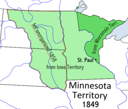
The Pembina Region was considered "unorganized" from 1818 until 1849. This means it didn't have a formal government like a state or a territory. In 1849, it became part of the Minnesota Territory. When Minnesota became a state in 1858, the Pembina area became unorganized again. Eventually, the land became part of the states of North and South Dakota.
Contents
Shaping the Pembina Region
Many things happened that shaped the Pembina Region in the United States.
The Louisiana Purchase
The Louisiana Purchase happened in 1803. This huge land deal included almost all of present-day South Dakota. It also included parts of Minnesota. This new land became known as the District of Louisiana.
The area was home to many Chippewa (also called Ojibwe) people. There were also fur trappers and Métis people. Métis people were a mix of French and Native American heritage.
Selkirk Concession
Thomas Douglas, 5th Earl of Selkirk wanted land from the British. But the Hudson's Bay Company had a monopoly, meaning they controlled all the land. So, Lord Selkirk bought a lot of control in the Hudson's Bay Company.
In 1811, he received a huge land grant called the Selkirk Concession. This area was 116,000 square miles. It became known as the Assiniboia Territory. It stretched south to the Red River watershed, near the 45th parallel north. The town of Pembina was inside this area.
Important Treaties
Several treaties helped define the borders of the Pembina Region.
- The Treaty of Paris (1783) ended the American Revolutionary War. But it didn't clearly set the northern border between the U.S. and Canada.
- The Jay Treaty (1796) and Treaty of Ghent (1814-1815) also tried to solve border issues.
- The Rush–Bagot Treaty (1818) was important for peace. It helped create a border without military forces.
- The Treaty of Washington (1871) later set up a way to solve international disagreements peacefully.
The Treaty of 1818 was signed on October 20, 1818. This treaty was a land swap. The British gave up land south of the new 49th parallel border. The U.S. gave up land north of the border. The land given to the U.S. was originally part of the Louisiana Purchase. It had been renamed the Missouri Territory in 1812. After the 1823 border survey, the Hudson's Bay Company realized Pembina was in the U.S. So, they moved their operations into southern Canada.
Becoming a Territory
After 1849, the Pembina Region became part of the Minnesota Territory. But when Minnesota became a state in 1858, the Pembina area became "unorganized" again. People in the area wanted a local government. They hoped this would encourage more people to settle there.
Later, the Dakota Territory was formed. But people still wanted more local control because the capital was far away. There were ideas to split the Dakota Territory into smaller parts. For example, in 1868, after gold was found in the Black Hills, some wanted to create a "Territory of Lincoln" in the west.
In 1872, there was a proposal to create the Pembina Territory. Its capital would be Bismarck. Another territory, Dakota (which is now South Dakota), would have Yankton as its capital. Finally, on November 2, 1889, a solution was found. Both North and South Dakota became separate states.
Gallery
-
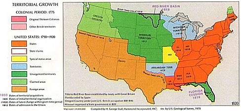
Territorial growth
-