Nataqua Territory facts for kids
The Nataqua Territory was an unofficial territory in the United States that lasted for only a short time. It included parts of what are now northeastern California and northwestern Nevada. Nataqua Territory was an early idea for a new state called "Jefferson."
In 1849, the border between California and the Utah Territory was set using geographical coordinates. However, this border was not actually surveyed on the ground.
Why it Started
On April 26, 1856, people living in the area used this unclear border to their advantage. They didn't want to pay taxes to Plumas County, California. So, they announced they were part of a new "Territory of Nataqua."
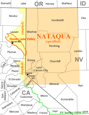
About 20 men from Susanville held a meeting. They decided on the borders for Nataqua using lines of latitude and longitude. By accident, they left out their own area, Honey Lake Valley! But they included most of what soon became western Nevada. This area had about 600 people who didn't even know about the new territory.
The Territory of Nataqua was like a club for settlers. It was designed to protect their land claims. This was important until a proper government could be set up in the area. Peter Lassen and Isaac Roop were the main leaders of this movement. People didn't want to be part of the Utah Territory. This was because of strong feelings against the Mormons at the time.
A New Territory is Born
By 1857, leaders in Honey Lake Valley worked with other settlers. These settlers were on the eastern side of the mountains, mainly in Carson Valley. They wanted to break away from Utah and California. Their goal was to create a new territory along the western edge of the interior plateau.
During these years, Honey Lake Valley largely governed itself. Even though it was officially a California township, Plumas County officials mostly left it alone. The unclear border and the chance of the eastern slope joining a new territory made them hesitant. This "on-the-fence" situation helped the settlers keep their independent spirit.
The desire for independence spread among settlers in nearby areas. These included Honey Lake Valley, Carson Valley, and Eagle Valley. In July 1859, they all declared independence from Eastern Utah. Isaac Roop was chosen as governor of the "Provisional Territorial Government of Nevada Territory" in September. He officially took office on December 13, 1859.
The End of Nataqua
In March 1861, the U.S. Congress officially created the Nevada Territory. The Honey Lake Valley and the area to its north were included in its first borders. Later that year, Lake County was formed, covering the area of the Nataqua Territory. It was renamed Roop County, Nevada in 1862.
However, in 1863, a border survey was done. It found that Susanville (which was named for Roop's daughter) and almost everyone in Roop County were actually in California. The California part of Roop County became part of the new Lassen County, California in 1864.
 | Mary Eliza Mahoney |
 | Susie King Taylor |
 | Ida Gray |
 | Eliza Ann Grier |


