Half-Breed Tract facts for kids
A Half-Breed Tract was a special area of land set aside in the western United States during the 1800s. The U.S. government created these areas specifically for people of American Indian and European heritage. At the time, these individuals were often called "half-breeds." These land tracts were located in several parts of the Midwest, including areas that are now Iowa, Nebraska, Kansas, Minnesota, and Wisconsin.
Contents
Understanding Half-Breed Tracts
Historically, many people of mixed heritage in the Great Lakes region were children of Native American women and European men. These men were often French-Canadian or Scottish fur traders. They lived far from other Europeans. Their children usually grew up within their mothers' tribes. These tribes often offered protection to the fathers and their families.
As the relationship between the U.S. government and Native American tribes became more complicated, mixed-race children often faced challenges. They were sometimes excluded from benefits meant for Native Americans. They also might not have had the same political rights as their European fathers. Tribes had their own rules about family and inheritance. For example, the Omaha tribe followed a system where children belonged to their father's family. They considered mixed-race children of European fathers to be white unless formally adopted. Other tribes followed a system where children belonged to their mother's family or clan.
Because many mixed-race children grew up within tribes, Europeans often saw them as more Native American than white. This was also true because their fathers often lived "outside" European society as mountain men. Leaders from tribes like the Omaha suggested setting aside land for their mixed-heritage descendants. The goal was usually to give land to the male heads of these families.
The rights of mixed-heritage people were especially affected when tribes gave up shared lands to the U.S. government. Their right to payments or a say in decisions was often not recognized. In 1830, the U.S. government addressed this issue with the Fourth Treaty of Prairie du Chien. This treaty set aside land for mixed-heritage people connected to the Oto, Ioway, Omaha, Sac and Fox, and Santee Sioux tribes. These "Half-Breed Tracts" were like small Indian reservations.
Iowa's Half-Breed Tract
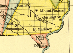
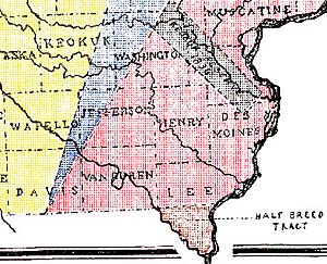
One Half-Breed Tract was located in Lee County, Iowa. In 1824, a treaty between the Sauk people, the Fox tribe, and the United States created this reservation. It was for mixed-heritage people related to these tribes. The tract was between the Mississippi River and Des Moines Rivers. It covered about 119,000 acres (482 square kilometers). Originally, mixed-heritage people could live on the land, but they could not buy or sell it.
In 1834, Congress changed this rule. Soon after, many people tried to illegally claim parts of the land. The government eventually gave away the claims of the mixed-heritage people. By 1841, the Half-Breed Tract in Iowa effectively ended.
The Mormon leader Joseph Smith, Jr. bought parts of the Half-Breed Tract around 1837. He bought it from a company that speculated on land. However, many of the land deeds were faulty. This meant the church ended up with only about 1,000 acres (4 square kilometers). This included a town called Commerce in Illinois. The Mormons moved there from Far West, Missouri, to escape a difficult order from the Missouri Governor.
Nebraska's Half-Breed Tract
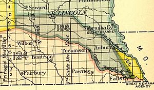
The Nemaha Half-Breed Reservation was created on July 15, 1830. Its eastern border was the Missouri River. The land stretched inland for 10 miles (16 kilometers). The northern border was the Little Nemaha River, and the southern border was the Great Nemaha River, near Falls City. Owners were not required to live on their land. Many eventually sold their properties to white settlers. Nebraska's Half-Breed Tract officially ended as a legal area by 1861.
Kansas's Half-Breed Tracts
In 1825, a treaty with the Kaw Indians set aside land for 23 mixed-heritage Kaw individuals. Each person received 1 square mile (640 acres) of land. These tracts were located on the north bank of the Kansas River. They stretched from what is now Topeka to Williamstown. The land was given to mixed-heritage people to gain their support for the treaty. In this treaty, the Kaw gave a large amount of land to the United States.
Several of these Kaw half-breed tracts became important places in Kansas history. In 1827, the Kaw Agency was built on Tract number 23. This land belonged to Joseph James, Jr.. The government agent for the Kaw lived here, along with a farmer named Daniel M. Boone (son of the famous pioneer Daniel Boone). Also living there were blacksmiths, mixed-heritage Kaw-French traders, and White Plume, the main chief of the Kaw. Tract number three, located where Topeka is today, became the site of the Pappan Ferry in the 1840s. This ferry was a crossing point on the Kansas River for pioneers traveling west on the Oregon Trail. Tract four was given to Julie Gonville. She was the grandmother of Charles Curtis, who later became a U.S. Senator from Kansas and the Vice President of the United States.
A similar treaty was signed in 1825 between the Osage Indians and the United States. The Osage gave up lands in Missouri, Arkansas, and Oklahoma. In return, they received a reservation in Kansas and Oklahoma. Forty-two tracts of 1 square mile each were set aside for the mixed-heritage children of French traders and Osage women. Most of these tracts were in eastern Kansas, but a few were on the Neosho River in Oklahoma.
Minnesota and Wisconsin's Half-Breed Tract
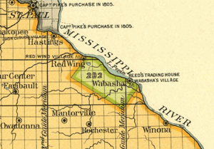
The 1830 Treaty of Prairie du Chien described the boundaries of a Half-Breed Tract around Lake Pepin. The treaty stated: "The Sioux bands... have asked that they might give to the half-breeds of their nation the land within these limits: Starting at the place called the Barn, near the village of the Red Wing chief, and going back fifteen miles; then, in a line parallel to Lake Pepin and the Mississippi, about 32 miles, to a point across from the river. The United States agrees to let these half-breeds live on this land. They will hold it with the same rights as other Indian lands."
This description includes a large part of what is now Wabasha County, Minnesota, and some of Goodhue County, Minnesota. Even though several mixed-heritage landowners had lived there for more than twelve years, the U.S. government took the land in 1852. They claimed it was to make up for the Sioux breaking an earlier treaty. The government took the land after explorers found that the area might have valuable minerals like lead and copper.
 | Claudette Colvin |
 | Myrlie Evers-Williams |
 | Alberta Odell Jones |


