
Scott County, Tennessee facts for kids
Quick facts for kids
Scott County
|
|
|---|---|

Scott County Courthouse in Huntsville
|
|

Location within the U.S. state of Tennessee
|
|
 Tennessee's location within the U.S. |
|
| Country | |
| State | |
| Founded | 1849 |
| Named for | Winfield Scott |
| Seat | Huntsville |
| Largest town | Oneida |
| Area | |
| • Total | 533 sq mi (1,380 km2) |
| • Land | 532 sq mi (1,380 km2) |
| • Water | 0.9 sq mi (2 km2) 0.2% |
| Population
(2020)
|
|
| • Total | 22,039 |
| • Density | 41/sq mi (16/km2) |
| Time zone | UTC−5 (Eastern) |
| • Summer (DST) | UTC−4 (EDT) |
| Congressional districts | 3rd, 6th |
Scott County is a county in the state of Tennessee, USA. In 2020, about 22,039 people lived there. The main town, called the county seat, is Huntsville. The biggest town is Oneida.
Scott County is famous for something special. During the Civil War, it decided to separate from Tennessee. This was because Tennessee joined the Confederacy. Scott County then called itself The Free and Independent State of Scott.
Contents
History of Scott County
Scott County was created in 1849. It was made from parts of other counties nearby. These included Anderson, Campbell, Fentress, and Morgan counties.
The county is named after U.S. Army General Winfield Scott. He was a hero in the Mexican War.
The Free and Independent State of Scott
During the Civil War, many people in Scott County supported the Union. They did not want to leave the United States. In June 1861, Tennessee voted to join the Confederacy. Scott County voted strongly against this. About 96% of its people voted to stay with the Union.
A U.S. Senator named Andrew Johnson gave a speech in Huntsville in 1861. He encouraged people to support the Union. Because of this strong feeling, the county leaders made a special decision. They officially announced that Scott County was leaving Tennessee. This meant they were also leaving the Confederacy. They called themselves the "Free and Independent State of Scott."
Scott County stayed a pro-Union area throughout the war. Even after the war, people there continued to support the Union. For example, Ulysses S. Grant, a Union general, received over 90% of the votes in Scott County. This happened in both the 1868 and 1872 presidential elections.
The special announcement about the "State of Scott" lasted a long time. It was finally canceled by Scott County in 1986. This was more than 100 years later.
Geography and Nature


Scott County covers about 533 square miles. Most of this area is land. Only a small part, about 0.9 square miles, is water. The county is in a hilly area. It sits on top of the Cumberland Plateau.
In the southwest part of the county, two rivers meet. These are the Clear Fork and the New River. They form the Big South Fork of the Cumberland River. This is a large river that flows into the Cumberland River. This area is now a national park. It is called the Big South Fork National River and Recreation Area.
Protected Natural Areas
Scott County has some beautiful protected areas. These places help keep nature safe.
- Big South Fork National River and Recreation Area (part)
- North Cumberland Wildlife Management Area (part)
- Scott State Forest (part)
- Twin Arches State Natural Area (part)
People and Population
In 2020, there were 21,850 people living in Scott County. There were 8,664 households, which are groups of people living together. Most people in Scott County are White. About 95.91% of the population is White (non-Hispanic).
Schools in Scott County
Scott County has two main school districts.
Scott County School District
- Burchfield Elementary School
- Farview Elementary School
- Huntsville Elementary School
- Huntsville Middle School
- Robbins Elementary School
- Scott High School
- Winfield Elementary School
Oneida Special School District
- Oneida Elementary School
- Oneida Middle School
- Oneida High School
Private Schools
- Landmark Christian School
Towns and Communities
Scott County has several towns and communities.
- Huntsville (This is the county seat, the main town for county government)
- Oneida
- Winfield
Famous People from Scott County
Some well-known people have come from Scott County:
- Howard Baker Sr. - He was a U.S. Representative. This means he helped make laws for the country.
- Howard Baker Jr. - He was a U.S. Senator. He was the first Republican from Tennessee to be elected to the U.S. Senate in a long time.
- Mike Duncan - He used to be in charge of the Republican National Committee. He also led the U.S. Postal Service and the Tennessee Valley Authority.
- Sparky Woods - He was a college football coach.
- Mike Marlar - He is a racing driver.
Images for kids
-
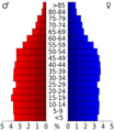
Age pyramid for Scott County

See also
 In Spanish: Condado de Scott (Tennessee) para niños
