Jones County, Mississippi facts for kids
Quick facts for kids
Jones County
|
|||
|---|---|---|---|

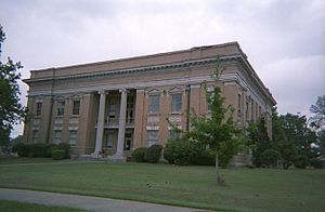
Jones County courthouse in Ellisville
|
|||
|
|||

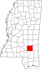
Location within the U.S. state of Mississippi
|
|||
 Mississippi's location within the U.S. |
|||
| Country | |||
| State | |||
| Founded | 1826 | ||
| Named for | John Paul Jones | ||
| Seat | Laurel and Ellisville | ||
| Largest city | Laurel | ||
| Area | |||
| • Total | 700 sq mi (2,000 km2) | ||
| • Land | 695 sq mi (1,800 km2) | ||
| • Water | 4.9 sq mi (13 km2) 0.7% | ||
| Population
(2020)
|
|||
| • Total | 67,246 | ||
| • Density | 96/sq mi (37.1/km2) | ||
| Time zone | UTC−6 (Central) | ||
| • Summer (DST) | UTC−5 (CDT) | ||
| Congressional districts | 3rd, 4th | ||
Jones County is located in the southeastern part of Mississippi, a state in the United States. In 2020, about 67,246 people lived here. The county has two main towns where its government offices are located: Laurel and Ellisville. Jones County is also part of the larger Laurel micropolitan area.
Contents
History of Jones County
Less than ten years after Mississippi became the 20th U.S. state, settlers created Jones County in 1826. This area was mostly pine forests and swamps. They named the county after John Paul Jones, a famous American Naval hero from the American Revolution.
Ellisville, one of the county seats, was named for Powhatan Ellis. During tough economic times in the 1830s and 1840s, many people left this part of Mississippi. They moved to western Mississippi, Louisiana, or even Texas to find new opportunities.
In 1860, most white residents in Jones County were not slave owners. Slaves made up only 12% of the population, which was the smallest percentage in Mississippi. This was because the land was better for farming timber and raising cattle than for growing cotton, which relied heavily on enslaved labor.
Civil War Years
In November 1860, after Abraham Lincoln was elected president, Mississippi decided to leave the Union. This was led by states with many slave owners. On January 7, 1861, Mississippi voted to secede (leave the Union). The representative from Jones County, John H. Powell, voted for secession. However, many people in Jones County did not support leaving the Union.
Mississippi's reason for leaving the Union was mainly to protect slavery. But Jones County had many small farmers and cattle herders who did not own slaves. They did not see a reason to fight a war over slavery.
During the American Civil War, Jones County became a safe place for soldiers who left the Confederate army. Many soldiers deserted because they lacked food and supplies. They also worried about their families back home. The Confederate government also took food and supplies from small farms. Another reason for anger was the Twenty Negro Law. This law allowed wealthy plantation owners to avoid fighting if they owned 20 or more slaves. This made many regular soldiers feel that the war was unfair.
The Free State of Jones
On October 13, 1863, a group of deserters from Jones County and nearby areas formed a group to protect themselves. They wanted to stop Confederate officials from collecting taxes and forcing men into the army. This group was led by Newton Knight. They created their own government, which supported the Union. This area became known as the "Free State of Jones."
Knight's group fought 14 battles with Confederate forces. They also raided a town called Paulding. There, they took five wagonloads of corn that had been collected as taxes and gave it back to the local people. By spring 1864, Knight's group had taken control of the county from the Confederate government.
Knight's followers even raised an American flag over the courthouse in Ellisville. They sent a letter to Union General William T. Sherman, saying that Jones County was independent from the Confederacy. In July 1864, a newspaper reported that Jones County had left the Confederacy.
Historians still debate if the county truly seceded. The story of Newton Knight and his followers became a legend. In 2016, a movie called Free State of Jones was made about these events.
After the Civil War, on November 30, 1865, the county changed its name to Davis County after Confederate president Jefferson Davis. But four years later, it changed back to Jones County.
Geography
Jones County covers about 700 square miles (1,800 square kilometers). Most of this area, about 695 square miles (1,790 square kilometers), is land. The remaining 4.9 square miles (13 square kilometers) is water.
Neighboring Counties
- Jasper County (north)
- Wayne County (east)
- Perry County (southeast)
- Forrest County (southwest)
- Covington County (west)
- Smith County (northwest)
Protected Areas
- De Soto National Forest (part)
Population Information
| Historical population | |||
|---|---|---|---|
| Census | Pop. | %± | |
| 1830 | 1,471 | — | |
| 1840 | 1,258 | −14.5% | |
| 1850 | 2,164 | 72.0% | |
| 1860 | 3,323 | 53.6% | |
| 1870 | 3,313 | −0.3% | |
| 1880 | 3,828 | 15.5% | |
| 1890 | 8,333 | 117.7% | |
| 1900 | 17,846 | 114.2% | |
| 1910 | 29,885 | 67.5% | |
| 1920 | 32,919 | 10.2% | |
| 1930 | 41,492 | 26.0% | |
| 1940 | 49,227 | 18.6% | |
| 1950 | 57,235 | 16.3% | |
| 1960 | 59,542 | 4.0% | |
| 1970 | 56,357 | −5.3% | |
| 1980 | 61,912 | 9.9% | |
| 1990 | 62,031 | 0.2% | |
| 2000 | 64,958 | 4.7% | |
| 2010 | 67,761 | 4.3% | |
| 2020 | 67,246 | −0.8% | |
| 2023 (est.) | 66,250 | −2.2% | |
| U.S. Decennial Census 1790-1960 1900–1990 1990-2000 2010–2013 |
|||
Here's a look at the different groups of people living in Jones County in 2020:
| Race | Num. | Perc. |
|---|---|---|
| White (non-Hispanic) | 41,676 | 61.98% |
| Black or African American (non-Hispanic) | 19,135 | 28.46% |
| Native American | 364 | 0.54% |
| Asian | 272 | 0.4% |
| Pacific Islander | 24 | 0.04% |
| Other/Mixed | 1,636 | 2.43% |
| Hispanic or Latino | 4,139 | 6.16% |
In 2020, there were 67,246 people living in Jones County. This included 24,178 households and 16,729 families.
Economy
The economy of Jones County still mostly relies on its natural resources. These include timber (wood from trees) and agriculture (farming).
Here are some of the largest employers in Jones County:
| # | Employer | Employees |
|---|---|---|
| 1 | Howard Industries | 3,700 |
| 2 | South Central Regional Medical Center | 1,837 |
| 3 | Ellisville State School | 1,459 |
| 4 | Jones County School District | 1,162 |
| 5 | Sanderson Farms | 889 |
| 6 | Wayne Farms | 715 |
| 7 | Laurel School District | 600 |
| 8 | Walmart | 585 |
| 9 | Masonite | 556 |
| 10 | Jones County | 510 |
| 11 | Sawmill Square Mall | 450 |
| 12 | Jones County Junior College | 427 |
| 13 | MS Industries for Individuals with Disabilities | 415 |
| 14 | Southern Hens | 390 |
| 15 | City of Laurel | 317 |
| 16 | Tanner Construction | 185 |
| 17 | Hudson's Salvage Center | 153 |
| 18 | Dunn Roadbuilders | 145 |
| 19 | Morgan Brothers Millwork | 137 |
| 20 | West Quality Food Service | 135 |
Transportation
Major Highways
 Interstate 59
 U.S. Highway 11
 U.S. Highway 84
 Mississippi Highway 15
 Mississippi Highway 28
 Mississippi Highway 29
Airport
The Hattiesburg-Laurel Regional Airport is located in Jones County, near the town of Moselle.
Communities
Cities
Towns
Census-designated places
These are areas that are like towns but are not officially incorporated as cities or towns.
- Eastabuchie
- Moselle
- Ovett
- Sharon
Unincorporated Communities
These are smaller communities that are not officially part of a city or town.
Education
Jones County has two main school districts: the Jones County School District and the Laurel School District. Most of Laurel is part of the Laurel School District.
Students in Jones County can also attend Jones College.
Notable People
Many interesting people have come from Jones County, including:
- Lance Bass, a singer with the band NSYNC
- Ralph Boston, an Olympic medalist in track and field
- Jason Campbell, a retired National Football League quarterback
- Mary Elizabeth Ellis-Day, an actress
- Carroll Gartin, a former lieutenant governor of Mississippi
- Newton Knight, a farmer and leader of the Knight Company during the Civil War
- Ira Clinton Welborn, who received the Medal of Honor
- Tom Lester, an actor known for playing "Eb" on Green Acres
- Amos McLemore, a schoolteacher and pastor
- Charles W. Pickering, a retired Federal Circuit Judge
- Parker Posey, an actress
- Leontyne Price, a famous opera singer
- James Street, an author
- Ray Walston, an actor known for My Favorite Martian
See also
 In Spanish: Condado de Jones (Misisipi) para niños
 | Bessie Coleman |
 | Spann Watson |
 | Jill E. Brown |
 | Sherman W. White |


