
Sandersville, Mississippi facts for kids
Quick facts for kids
Sandersville, Mississippi
|
|
|---|---|

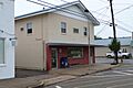
The U.S. Post Office in Sandersville, Mississippi
|
|

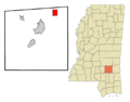
Location of Sandersville, Mississippi
|
|

Sandersville, Mississippi
Location in the United States
|
|
| Country | United States |
| State | Mississippi |
| County | Jones |
| Area | |
| • Total | 4.99 sq mi (12.92 km2) |
| • Land | 4.95 sq mi (12.82 km2) |
| • Water | 0.04 sq mi (0.10 km2) |
| Elevation | 276 ft (84 m) |
| Population
(2020)
|
|
| • Total | 636 |
| • Density | 128.46/sq mi (49.60/km2) |
| Time zone | UTC-6 (Central (CST)) |
| • Summer (DST) | UTC-5 (CDT) |
| ZIP code |
39477
|
| Area code(s) | 601 |
| FIPS code | 28-64920 |
| GNIS feature ID | 0677364 |
Sandersville is a small town located in Jones County, Mississippi. In 2020, about 636 people lived there. This was a bit less than the 731 people counted in 2010. Sandersville is part of the larger Laurel micropolitan area.
Contents
History of Sandersville
Early Settlers and Town Naming
Sandersville was settled by Scottish families in the 1820s. These early settlers built the Good Hope Presbyterian Church. In 1855, the town got its name from the Sanders family, who were important pioneers in the area.
Victorian Architecture in Town
Many homes in Sandersville have a special design from the Victorian era. You can often see small dome-like structures called cupolas on top of these buildings. This architectural style makes the town unique.
Local Industry: Oil Refining
A company called Hunt Refining Company has an oil refinery near Sandersville. This refinery processes crude oil, mostly from local Mississippi oil fields. It creates different products like asphalt for roads and other fuels.
Geography of Sandersville
Location and Nearby Cities
Sandersville is in the northeastern part of Jones County. It is located at 31°47′8″N 89°2′4″W. U.S. Route 11 (also known as Front Street) goes right through the middle of town. This road leads southwest about 9 miles to Laurel, which is the largest city in the county. It also goes northeast about 10 miles to Stafford Springs.
Major Highways and Travel
Interstate 59 passes just west of Sandersville. You can get on I-59 from Exit 104 (West Main Street). This interstate highway goes northeast about 48 miles to Meridian. It also goes southwest about 39 miles to Hattiesburg.
Town Size and Water Areas
According to the United States Census Bureau, Sandersville covers a total area of about 12.9 square kilometers (4.99 square miles). Only a small part of this area, about 0.1 square kilometers (0.04 square miles), is water.
Population and People
Population Changes Over Time
The number of people living in Sandersville has changed over the years. Here's a look at the population from different census counts:
| Historical population | |||
|---|---|---|---|
| Census | Pop. | %± | |
| 1900 | 357 | — | |
| 1910 | 604 | 69.2% | |
| 1920 | 559 | −7.5% | |
| 1930 | 565 | 1.1% | |
| 1940 | 562 | −0.5% | |
| 1950 | 681 | 21.2% | |
| 1960 | 657 | −3.5% | |
| 1970 | 694 | 5.6% | |
| 1980 | 800 | 15.3% | |
| 1990 | 853 | 6.6% | |
| 2000 | 789 | −7.5% | |
| 2010 | 731 | −7.4% | |
| 2020 | 636 | −13.0% | |
| U.S. Decennial Census | |||
Diversity in Sandersville (2020)
The town of Sandersville is home to people from different backgrounds. Here's a look at the racial makeup of the town in 2020:
| Race | Number | Percentage |
|---|---|---|
| White (NH) | 530 | 83.33% |
| Black or African American (NH) | 42 | 6.6% |
| Native American or Alaska Native (NH) | 29 | 4.56% |
| Asian (NH) | 1 | 0.16% |
| Mixed/Multi-Racial (NH) | 25 | 3.93% |
| Hispanic or Latino | 9 | 1.42% |
| Total | 636 |
In 2020, there were 636 people living in Sandersville. These people lived in 268 households, and 218 of these were families.
Households and Families (2000)
Back in the year 2000, there were 789 people living in Sandersville. They lived in 317 households, with 231 of these being families. About 31.9% of households had children under 18 living there. Most households (56.8%) were married couples. About 23.3% of all households were people living alone.
Age Groups (2000)
In 2000, the population of Sandersville was spread across different age groups. About 23.2% of the people were under 18 years old. About 16.7% were 65 years or older. The average age in the town was 39 years.
Education in Sandersville
Local School District
Students in Sandersville attend schools that are part of the Jones County School District. This district provides education for children in the area.
Higher Education Opportunities
For students looking to continue their education after high school, Jones County is in the zone for Jones College. This college offers various programs and courses.
Notable People from Sandersville
- Doug Satcher – He was a professional NFL linebacker.
- Shad White – He serves as the State Auditor of Mississippi.
Images for kids
-
The U.S. Post Office in Sandersville, Mississippi
-
Location of Sandersville, Mississippi
-

Learn more about Sandersville!

See also
 In Spanish: Sandersville (Misisipi) para niños
