Jasper County, Mississippi facts for kids
Quick facts for kids
Jasper County
|
|
|---|---|

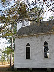
Historic Montrose Presbyterian Church
|
|

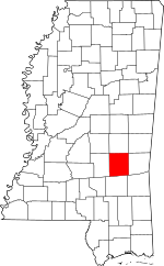
Location within the U.S. state of Mississippi
|
|
 Mississippi's location within the U.S. |
|
| Country | |
| State | |
| Founded | 1833 |
| Named for | William Jasper |
| Seat | Bay Springs and Paulding |
| Largest city | Bay Springs |
| Area | |
| • Total | 677 sq mi (1,750 km2) |
| • Land | 676 sq mi (1,750 km2) |
| • Water | 1.2 sq mi (3 km2) 0.2% |
| Population
(2020)
|
|
| • Total | 16,367 |
| • Density | 24.176/sq mi (9.334/km2) |
| Time zone | UTC−6 (Central) |
| • Summer (DST) | UTC−5 (CDT) |
| Congressional district | 3rd |
Jasper County is located in the state of Mississippi in the United States. In 2020, about 16,367 people lived here.
In 1906, the state decided to have two main towns for the county: Paulding in the east and Bay Springs in the west. Bay Springs grew because a railroad was built there. Soon, Bay Springs became bigger than Paulding.
For a long time, there wasn't a good road connecting the two parts of the county. One was finally built in 1935–1936. Even today, the county is mostly rural. It produces a lot of gas and oil, especially in the southeast. It also leads the state in producing timber, cattle, and poultry.
Contents
History of Jasper County
Jasper County was created in 1833. It was formed from a part of a much larger Jones County. The county is named after Sergeant William Jasper. He was a hero in the American Revolutionary War.
How Sergeant Jasper Became a Hero
In 1776, during a battle at Fort Moultrie, a British cannonball shot down the American flag. Sergeant Jasper bravely picked up the flag. He held it high under enemy fire until a new flagpole was put up. Sadly, Sergeant Jasper was killed in 1779 during the Siege of Savannah.
Early Days and Growth
In the early years, large farms grew cotton using the labor of enslaved people. Paulding, Mississippi was the main town then. It was a busy trading center for farms and other residents.
After the Civil War, many African Americans moved away from the rural South to northern cities. However, in 2010, about 52.6% of Jasper County's population was African American. This shows the county's long history with cotton farming and the strong family ties people have to this land.
Railroads and New Towns
Later in the 1800s, people in Paulding didn't want to invest in building railroads. So, the railroad route was moved to the west. This helped Bay Springs grow. A sawmill was built there in 1880.
Around 1900, Bay Springs became an official city. In 1906, the state made Bay Springs the second county seat. Big timber companies, like Georgia Pacific, and other businesses came to Bay Springs.
Connecting the County
It wasn't until 1935–1936 that the first main road was built across the county. This road connected Bay Springs in the west with Rose Hill in the east. This project was part of the WPA, a program during the Great Depression.
Modern Facilities
Bay Springs now has good medical facilities. Jasper General Hospital has been open since 1962. In 2012, Jasper General Patient Rehab was built to offer more care.
For fun, the county has a 9-hole golf course at the Bay Springs Country Club. You can also go fishing and hunting, especially around Lake Claude Bennett near Rose Hill.
Today, Jasper County is still mostly rural. It leads Mississippi in producing timber, cattle, and poultry. It's also the state's top producer of gas and oil, especially near Heidelberg.
Geography and Location
According to the U.S. Census Bureau, Jasper County covers about 677 square miles. Most of this (676 square miles) is land, and a small part (1.2 square miles) is water.
Main Roads and Highways
 Interstate 59
 U.S. Highway 11
 Mississippi Highway 15
 Mississippi Highway 18
 Mississippi Highway 503
 Mississippi Highway 513
 Mississippi Highway 528
 Mississippi Highway 531
 Mississippi Highway 533
Neighboring Counties
- Newton County (north)
- Clarke County (east)
- Wayne County (southeast)
- Jones County (south)
- Smith County (west)
Protected Areas
- Part of the Bienville National Forest is in Jasper County.
Population and People
| Historical population | |||
|---|---|---|---|
| Census | Pop. | %± | |
| 1840 | 3,958 | — | |
| 1850 | 6,184 | 56.2% | |
| 1860 | 11,007 | 78.0% | |
| 1870 | 10,884 | −1.1% | |
| 1880 | 12,126 | 11.4% | |
| 1890 | 14,785 | 21.9% | |
| 1900 | 15,394 | 4.1% | |
| 1910 | 18,498 | 20.2% | |
| 1920 | 18,508 | 0.1% | |
| 1930 | 18,634 | 0.7% | |
| 1940 | 19,484 | 4.6% | |
| 1950 | 18,912 | −2.9% | |
| 1960 | 16,909 | −10.6% | |
| 1970 | 15,994 | −5.4% | |
| 1980 | 17,265 | 7.9% | |
| 1990 | 17,114 | −0.9% | |
| 2000 | 18,149 | 6.0% | |
| 2010 | 17,062 | −6.0% | |
| 2020 | 16,367 | −4.1% | |
| 2023 (est.) | 16,013 | −6.1% | |
| U.S. Decennial Census 1790-1960 1900-1990 1990-2000 2010-2013 |
|||
| Race | Number of People | Percentage |
|---|---|---|
| White (not Hispanic) | 7,541 | 46.07% |
| Black or African American (not Hispanic) | 8,324 | 50.86% |
| Native American | 28 | 0.17% |
| Asian | 8 | 0.05% |
| Other/Mixed | 297 | 1.81% |
| Hispanic or Latino | 169 | 1.03% |
In 2020, there were 16,367 people living in Jasper County. There were 6,629 households and 4,746 families.
Education
Jasper County has two school districts:
- East Jasper School District
- West Jasper School District
The county is also in the area for Jones College.
Communities in Jasper County
Cities
- Bay Springs (this is one of the county seats)
Towns
Unincorporated Communities
These are smaller places that are not officially cities or towns.
Ghost Town
- Success (a town that no longer exists)
See also
 In Spanish: Condado de Jasper (Misisipi) para niños
 | Claudette Colvin |
 | Myrlie Evers-Williams |
 | Alberta Odell Jones |

