Garlandville, Mississippi facts for kids
Quick facts for kids
Garlandville, Mississippi
|
|
|---|---|

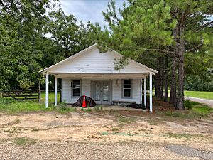
Closed store in Garlandville
|
|
| Country | United States |
| State | Mississippi |
| County | Jasper |
| Elevation | 456 ft (139 m) |
| Time zone | UTC-6 (Central (CST)) |
| • Summer (DST) | UTC-5 (CDT) |
| Area code(s) | 601 |
| GNIS feature ID | 693284 |
Garlandville is a small place in Jasper County, Mississippi, United States. It's known as an unincorporated community, which means it's a settlement without its own local government. It's located about 8.2 miles (13.2 km) south-southeast of Newton, right along Mississippi Highway 504.
Early History of Garlandville
Garlandville was first settled in 1833. This makes it one of the very oldest communities in Jasper County. The community got its name from a man named John Garland. He was a Choctaw person who ran a tavern in the area. Before the American Civil War, Garlandville was a very busy and successful place.
Garlandville During the Civil War
During the American Civil War, Garlandville played a small part. Many local men joined the Confederate States Army. Two groups of soldiers from Garlandville were formed to fight in the war.
Later, during a famous event called Grierson's Raid, soldiers from the Union Army rode through Garlandville. During this time, some local home guard soldiers fired shots. One Union Army horse was killed, and one soldier was seriously hurt.
After the War
After the Civil War ended, Garlandville changed a lot. Many of the shop owners and residents moved away. Only a few small businesses stayed open.
Garlandville also had its own post office for a long time. It operated under the name Garlandville from 1834 until 1953.
 | Janet Taylor Pickett |
 | Synthia Saint James |
 | Howardena Pindell |
 | Faith Ringgold |


