
Webster–Ashburton Treaty facts for kids

Webster–Ashburton Treaty ratification
|
|
| Type | Bilateral treaty |
|---|---|
| Signed | 9 August 1842 |
| Location | Washington, D.C., United States |
| Original signatories |
|
| Ratifiers |
|
The Webster–Ashburton Treaty was an important agreement signed on August 9, 1842. It helped solve several border problems between the United States and the British colonies in North America (which later became Canada).
This treaty was signed when John Tyler was the U.S. President. It ended the Aroostook War, which was a disagreement over the border between Maine and New Brunswick. This "war" was mostly peaceful, with no actual fighting.
The treaty did several key things:
- It set the border between Lake Superior and the Lake of the Woods. This border was first planned in the Treaty of Paris in 1783.
- It confirmed the border (at the 49th parallel) for the western frontier up to the Rocky Mountains. This part was first set in the Treaty of 1818.
- It listed seven types of crimes for which people could be sent back (extradited) to their home country.
- It called for a complete end to the slave trade on the open seas.
- It agreed that both countries would share the use of the Great Lakes.
The treaty also confirmed the southern border of Quebec. This border had been marked by surveyors in 1771–1773. The treaty aimed for the border to be at 45 degrees north latitude. However, in some places, the actual border is almost half a mile north of that line.
The treaty was signed by United States Secretary of State Daniel Webster for the U.S. and British diplomat Alexander Baring, 1st Baron Ashburton for Britain.
Contents
Setting the Eastern Border

Before this treaty, there was an attempt in 1831 to settle border issues in the East. The King of the Netherlands tried to help, but his decision was not accepted by both sides.
The Treaty of Paris had set the 45th parallel as part of the northern border for modern-day New York and Vermont. Most of this border was surveyed in the 1770s, but the survey line was not exact.
A U.S. fort, sometimes called "Fort Blunder," was built north of the true 45th parallel. The United States wanted to keep this old survey line. The Webster–Ashburton Treaty agreed to this change. This meant the unfinished fort stayed on U.S. land. After the treaty, the U.S. continued building this fort, which became known as Fort Montgomery.
This treaty also ended small fights between lumberjacks. These fights, known as the Aroostook War, happened along the Maine border. The new border divided the disputed land between the two nations. Britain got the route for the Halifax–Quebec road. Their military wanted this road because it was the only way to connect Lower Canada (now Quebec) to New Brunswick and Nova Scotia in winter.
The treaty also gave the United States a bit more land to the north. It settled problems from the Indian Stream dispute. The Indian Stream area was given to the United States. The treaty also helped resolve issues from the Caroline Affair. However, the treaty did not settle who owned Machias Seal Island and nearby North Rock. These places are still disputed today.
The treaty also stopped plans for improving British defense forts, like Fort Malden. The British government later abandoned these forts. They were no longer needed for defense after the border was settled.
Setting the Western Border

The border between Lake Superior and the Lake of the Woods also needed to be made clear. The map used for the Treaty of Paris in 1783 was not good enough. This led to confusion about the border in Minnesota's Arrowhead Region. Earlier talks had not fixed this problem.
The treaty said the border would go through Long Lake. However, it did not say where this lake was. The old map showed the lake flowing into Lake Superior near Isle Royale. This matched the Pigeon River route.
The British had thought the border should start at the "head of the lake" (Fond du Lac) in modern Duluth, Minnesota. From there, it would go up the Saint Louis and Embarrass rivers. Then it would cross a high point of land and go down Pike River and Lake Vermilion to the Rainy River.
The U.S. wanted an eastern route. This route was used by early French explorers and fur traders. It went north from Lake Superior at Fort William. Then it went up the Kaministiquia and Dog Rivers to Cold Water Lake. It crossed to Height of Land Lake and then went west to Lake La Croix, where it joined the current border.
The old map showed both these routes. It also showed the "Long Lake" route between them. Long Lake was thought to be the Pigeon River.
The usual route for traders started at Grand Portage. It went overland to the Pigeon River, then up that river and a smaller river. It crossed a high point of land and then went down rivers that flow into the Rainy River. This route went to Lac La Croix, Rainy Lake and River, and Lake of the Woods. This is the route the treaty finally chose for the border.
The treaty also made clear the path the border would follow between Lake Huron and Lake Superior. It gave Sugar Island to the U.S.
Another important point settled was the Northwest Angle. Due to errors on the old map, the Treaty of Paris said the border went "... through the Lake of the Woods to the most northwesternmost point thereof, and from thence on a due west course to the river Mississippi ..." But a line going due west from the Lake of the Woods never reaches the Mississippi River. The Anglo-American Convention of 1818 had defined the border from Lake of the Woods to the Rocky Mountains.
The 1842 treaty confirmed this border. It made it even clearer by changing the border description to:
... at the Chaudiere Falls, from which the Commissioners traced the line to the most northwestern point of the Lake of the Woods, thence, along the said line to the said most northwestern point, being in latitude 49°23′55″ north, and in longitude 95°14′38″ west from the Observatory at Greenwich; thence, according to existing treaties, due south to its intersection with the 49th parallel of north latitude, and along that parallel to the Rocky Mountains ...
The Webster–Ashburton Treaty did not deal with the Oregon question. This issue was discussed during the talks, but no agreement was reached.
Other Important Issues
Article 10 of the Webster–Ashburton Treaty listed seven crimes for which people could be extradited. These were: "murder, or assault with intent to commit murder, or piracy, or arson, or robbery, or forgery, or the utterance of forged paper." It did not include slave rebellions or mutiny. Also, the United States did not ask for the return of about 12,000 enslaved people who had escaped to Canada.
Both Webster and Ashburton agreed to work towards ending the slave trade on the high seas. However, they decided not to discuss the Creole case from 1841. In November 1841, a slave rebellion happened on an American ship called the Creole. The ship was forced to go to Nassau. Officials in the Bahamas freed all 128 enslaved people who chose to stay there. This was because Britain had ended slavery in its colonies in 1834. The U.S. first demanded the return of the enslaved people, then asked for money. A settlement was reached in 1855 as part of a larger agreement.
The treaty set minimum levels for naval activity to stop the slave trade off the West African coast. Both the U.S. Navy and the Royal Navy had to patrol these waters. This made official a type of cooperation that had existed briefly before. However, it did not allow ships from one country to search ships flying the other country's flag. This meant it had only a small effect on reducing the slave trade.
Results of the Treaty

Because of the Webster–Ashburton Treaty, the United States gave up about 5,000 square miles (13,000 km2) of disputed land along the Maine border. This included the Halifax–Quebec Route. But the U.S. kept 7,000 square miles (18,000 km2) of the disputed wilderness.
Also, the United States gained about 6,500 square miles (17,000 km2) of land along the Minnesota–Canada border. This land included the Mesabi Range, which is rich in iron ore.
Soon after the treaty was approved, the Ojibwa nations near Lake Superior gave land to the United States in the Treaty of La Pointe. However, the news of the Webster–Ashburton Treaty had not reached them yet. The Grand Portage Band was accidentally left out of the Ojibwe treaty council. They also misunderstood the details of the Treaty of Paris. They thought the border went through the middle of Lake Superior to the Saint Louis River, placing both Isle Royale and their band in British territory. The Treaty of Paris actually said Isle Royale was in U.S. territory. So, the Isle Royale Agreement was signed in 1844. This agreement was between the U.S. and the Grand Portage Band. Other Ojibwa tribes also confirmed the treaty.
The talks for the treaty lasted ten months. They mostly took place at the Ashburton House in Washington, D.C. This house was where the British diplomats stayed. It is now a U.S. National Historic Landmark.
To make the treaty more popular in the United States, Daniel Webster showed a map of the Maine–Canada border. He claimed Benjamin Franklin had drawn it. This map showed the disputed areas mostly favoring the United States.
Images for kids
-
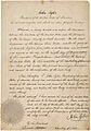
Webster–Ashburton Treaty ratification
-
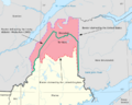
Settlement in the East. The disputed areas are shown in red and the boundary established by the treaty in green.
-
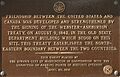
Plaque in Washington, D.C.
-
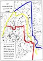
Maine boundary dispute that led to the 1842 Webster–Ashburton Treaty
See also
 In Spanish: Tratado Webster-Ashburton para niños
