Aroostook War facts for kids
Quick facts for kids Aroostook War |
|||||||
|---|---|---|---|---|---|---|---|
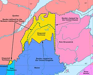
 Map showing the boundary claims and final border |
|||||||
|
|||||||
| Belligerents | |||||||
| Strength | |||||||
| 6,000 | 15,000 | ||||||
| Casualties and losses | |||||||
| None | 2 injured by bears | ||||||
| 38 non-combat deaths | |||||||
The Aroostook War (also called the Pork and Beans War or Madawaska War) was a disagreement between the United States and the United Kingdom. It happened in 1838–1839. The two countries argued over where the border should be between the British colony of New Brunswick and the U.S. state of Maine.
Even though it was called a "war," no actual fighting took place between soldiers. Local groups of citizen soldiers (called militia) were called up, but they never fought. It's better to think of it as a serious international argument.
A British diplomat named Alexander Baring, 1st Baron Ashburton and the U.S. Secretary of State, Daniel Webster, worked together to solve the problem. They signed the Webster–Ashburton Treaty in 1842. This treaty set the final border. Most of the disputed land went to Maine. However, it also made sure there was a land route connecting Lower Canada (now part of Quebec) and the Maritime colonies (like Nova Scotia and New Brunswick).
Contents
Why Was the Border Disputed?
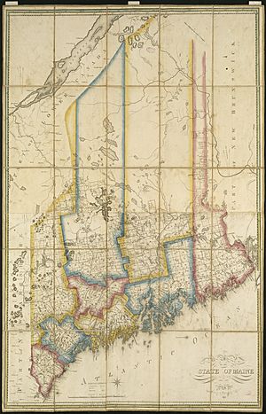
The Treaty of Paris (1783) ended the American Revolutionary War. But it didn't clearly draw the border between British North America (which included Quebec and New Brunswick) and the United States. Because of this, the state of Massachusetts (which Maine was part of then) started giving out land in its District of Maine. Some of this land was also claimed by the British.
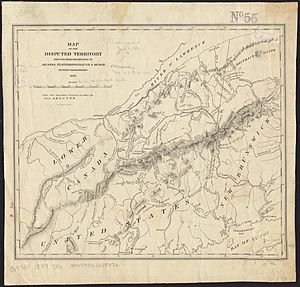
People started questioning the border soon after. In 1794, the Jay Treaty suggested a group should figure out where the St. Croix River started. This river was an important landmark mentioned in the earlier treaty. In 1798, this group decided on the southern part of the border. But they didn't finish the details for the border north of the lakes. This northern part was supposed to be a straight line to highlands that separated rivers flowing into the Saint Lawrence River from those flowing south.
During the War of 1812, the British took control of much of eastern Maine for eight months. They wanted to make it part of British North America permanently.
The Treaty of Ghent ended the War of 1812 in 1815. It brought back the border lines from the 1783 treaty. Another group was formed to sort out the remaining issues. When Maine became its own state in 1820, figuring out the border became a big deal for its new government. Massachusetts still cared too, because it owned half of Maine's public lands, including much of the disputed area.
The British worried that Maine's land reached too far into their territory. It almost touched the St. Lawrence River in some places. This made it hard to communicate between Lower Canada and the Maritime colonies. If they controlled the northern part of Maine, travel time between Quebec City and Halifax would be cut almost in half.
Even in 1825, land agents from Maine and Massachusetts were selling timber permits and recording births and deaths in the disputed area. A huge forest fire, the Miramichi Fire, happened in 1825. It destroyed a lot of timber in New Brunswick. This made New Brunswick even more determined to control the forests in the disputed area.
Growing Tensions
French-speaking settlers, called Acadians, mostly lived in the Saint John and Madawaska River areas. Some Americans also settled in the Aroostook River Valley. Between 1826 and 1830, British timber companies also moved into the area.
The French-speaking people of Madawaska were called "Brayons." They were technically British subjects, but they often said they belonged to their own "République du Madawaska." This meant they didn't feel loyal to either the Americans or the British.
More people, especially lumberjacks, came to the area in winter. These seasonal workers caused problems for the governments of Maine and Massachusetts. They were trying to protect their natural resources and collect money from them. People often argued over who had the right to cut down the best trees.
On July 4, 1827, an American named John Baker raised an American flag. His wife had made it. He put it up on the western bank of Baker Brook, which is now in Canada. New Brunswick authorities arrested Baker. They fined him and put him in jail until he paid.
The Crisis of 1830
In 1830, the Maine Legislature sent two men, John Deane and Edward James, to the disputed area. They were supposed to count the people and see how much land the British were using. Some residents in the Madawaska area wanted their land to be part of Maine. They held meetings to choose representatives to make Madawaska a town.
New Brunswick militia members broke into one of these meetings. They threatened to arrest anyone trying to organize. But the meetings continued. More militia arrived, and some residents were arrested. Others ran into the woods. Local Americans sent letters to Maine's leaders in Augusta.
The Treaty of Ghent (signed in 1815) said that if a joint group couldn't agree on the border, a neutral third party should decide. So, the United States and Britain asked King William I of the Netherlands to help.
King William was given maps and arguments from both sides. He found it very hard to match the treaty description with the map. On January 20, 1831, he said the treaty was "unclear and impossible to use." He then suggested a compromise border line between the two options. The United States would get about 7,908 square miles (20,482 km²) and Britain would get about 4,119 square miles (10,668 km²).
The British government accepted this decision. But Maine rejected it, and the U.S. Senate didn't approve the new treaty. This refusal by the Americans meant the United States would later lose about 900 square miles (2,331 km²) of land.
Posses, Arrests, and Militia
In 1835, the British changed their mind and no longer accepted the Dutch compromise. They offered a new border, which the Americans rejected. The United States then offered to use the Saint John River as the border, but the British said no.
In 1836, Maine took a special count of its population. A census taker, Ebenezer Greeley, started counting people in the upper Aroostook River area. Governor John Harvey of New Brunswick had Greeley arrested. Letters from New Brunswick accused Maine's Governor of trying to bribe people. They also threatened military action if Maine kept trying to control the Aroostook River area.
In response, Governor Robert Dunlap of Maine announced that a foreign power had invaded Maine. In March 1838, Maine demanded a survey based on its claim. It also asked the U.S. federal government to enforce this claim. Washington refused, but did allow a survey for possible forts. Maine's state legislature set aside $800,000 for military defense. Congress gave the President power to call up the militia with a $10,000,000 budget. Meanwhile, Nova Scotia voted $100,000 to help defend New Brunswick.
Both American and New Brunswick lumberjacks were cutting timber in the disputed area during the winter of 1838–1839. This led to small fights, like the Battle of Caribou. On January 24, 1839, the Maine Legislature told Governor John Fairfield to send Maine's land agent, Rufus McIntire, and a group of volunteer militia to the upper Aroostook. Their job was to find and arrest the New Brunswickers.
The group left Bangor, Maine, on February 8, 1839. They set up a camp and started taking New Brunswick lumbering equipment. They sent arrested lumbermen back to Maine for trial. A group of New Brunswick lumbermen found out about this. They broke into a weapons storage in Woodstock to arm themselves. They then captured the Maine land agent and his helpers in the middle of the night. These New Brunswickers took the Maine officials in chains to Woodstock.
Sir John Harvey called the Americans "political prisoners." He wrote to Washington, DC, saying he couldn't act on the arrests without orders from London. He also said he would make sure British law was followed in the Aroostook area. He demanded that all Maine forces leave the region. He then sent his military commander to the Maine camp and ordered the militia to leave. The Maine soldiers refused, saying they were following orders. The Maine side then arrested the New Brunswick military commander.
On February 15, 1839, the Maine Legislature approved sending 1,000 more volunteers to the Aroostook River. News arrived that British Army troops were coming from the West Indies. There were also reports that the Mohawk nation offered to help Quebec. New Brunswick forces were also gathering on the Saint John River. Because of this, Maine called for a general draft of its militia on February 19, 1839. Maine militia companies gathered in Bangor and traveled to the Upper Aroostook. They built Fort Fairfield from timber they had seized.
Governments Step In
In Washington, D.C., on March 2, 1839, Representative Francis Ormand Jonathan Smith of Maine explained the situation to Congress. He said it was the national government's job to protect its land and citizens. But he also said Maine would defend its territory alone if the national government didn't help.
President Martin Van Buren sent Brigadier General Winfield Scott to the area. General Scott had been a prisoner of war under Sir John Harvey during the War of 1812. This past connection helped them have mutual respect.
Congress debated the issue. In April and May 1839, Congress allowed for a force of 50,000 men and set aside $10 million. This money was for the President to use if foreign troops entered U.S. territory during the summer. Maine had first sent between three thousand and ten thousand militia members.
Following General Scott's advice, Maine recalled its militia in May and June 1839. They replaced them with an armed civilian group. This group was led by the Maine state land agent. The United States Army started building permanent forts: Fort Fairfield in April 1839 and Fort Kent in October 1839. British troops also arrived from Quebec City. New Brunswick armed every river flowing from the Aroostook Territory with soldiers.
In 1840, Maine created Aroostook County, Maine, to manage the area. The two nations agreed to send the dispute to a border commission. However, small clashes between their forces continued during this time.
How the Dispute Was Settled
Neither the United States nor Britain wanted a full-scale war. A war would have greatly harmed trade between them. Daniel Webster and Alexander Baring, 1st Baron Ashburton reached a compromise. This was the Webster–Ashburton Treaty of Washington in 1842.
This treaty settled the border between Maine and Canada. It also set the border between Canada and New Hampshire, Michigan, and Minnesota. The treaty gave about 7,015 square miles (18,169 km²) to the United States. It gave about 5,012 square miles (12,981 km²) to British control. The British kept the northern part of the disputed land. This included the "Halifax Road," which was important for military communication between Quebec and Nova Scotia.
The U.S. federal government agreed to pay Maine and Massachusetts $150,000 each. This was for the land they lost and for the money they spent during the time Maine's armed civilian group managed the truce.
Webster used a map that an American, Jared Sparks, found in Paris. This map supposedly had a red line drawn by Benjamin Franklin. It seemed to show that the disputed area belonged to the British. Webster used this map to convince Maine and Massachusetts to accept the agreement. Webster later said he didn't feel it was his duty to tell Lord Ashburton about this "doubtful evidence." Ashburton agreed. The British Foreign Office also hid a map that generally supported the American side. Some people believe the British created the Franklin map as a fake to pressure the American negotiators.
Some people in Britain, like Lord Palmerston, were unhappy with the treaty. But the British government was pleased. Maine and Massachusetts complained but were happy to be paid for the land. Canada was unhappy. They felt the treaty was Britain trying to improve relations with the U.S. by giving American territory that separated Lower Canada from the Maritimes.
Canada did keep an important connection between Lower Canada and the Maritime colonies. They also kept a plan for a commercial route that would let British businesses travel through Maine. This route is still used today by railways.
Casualties
Even though there was no direct fighting in the Aroostook War, some militiamen died from accidents and diseases. One example was Private Hiram T. Smith.
In Popular Culture
The tensions that led to the Aroostook War are mentioned in a short story from 1835 called "The Squatter." It was written by John Neal. The main character, Hayes, talks about these events from a soldier's point of view before the conflict became very serious.
See also
 In Spanish: Guerra de Aroostook para niños
 | Kyle Baker |
 | Joseph Yoakum |
 | Laura Wheeler Waring |
 | Henry Ossawa Tanner |


