Aroostook River facts for kids
Quick facts for kids Aroostook River |
|
|---|---|

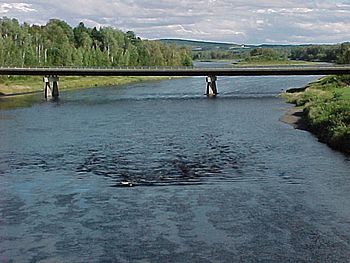
Aroostook River at Washburn, Maine
|
|

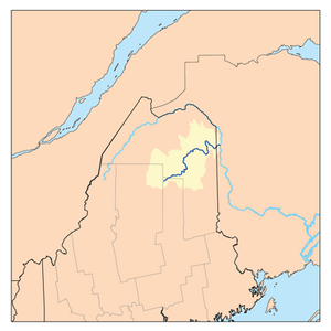
Aroostook River watershed
|
|
| Country | United States, Canada |
| State | Maine |
| Province | New Brunswick |
| Cities | Ashland, Maine, Washburn, Maine, Presque Isle, Maine, Caribou, Maine, Fort Farfield, Maine |
| Physical characteristics | |
| River mouth | Saint John River (New Brunswick) Aroostook, NB 330 ft (100 m) 46°48′36″N 67°42′58″W / 46.810123°N 67.71620°W |
| Length | 112 mi (180 km) |
| Discharge (location 2) |
|
| Basin features | |
| Basin size | 2,442.7 sq mi (6,327 km2) |
| Watershed data. | |
The Aroostook River is a river that flows for about 112-mile-long (180 km). It is a branch, or tributary, of the larger Saint John River. The Aroostook River flows through the U.S. state of Maine and the Canadian province of New Brunswick. Its drainage area is the biggest part of the Saint John River's water system.
The name "Aroostook" comes from the Malecite language. It means "good river for everything."
Contents
River History
What was the Aroostook War?
In the late 1830s, the land around the Aroostook River was part of a disagreement. This disagreement was called the Aroostook War. It was a border dispute between the United States and the United Kingdom. Both countries claimed the land. Even though it was called a "war," there was no actual fighting. The dispute was settled peacefully.
River Geography
Where Does the Aroostook River Start?
The Aroostook River begins in northeastern Maine. It forms where two smaller streams, Millinocket Stream and Munsungan Stream, meet. This meeting point is in a wild area of northern Penobscot County.
Where Does the River Flow?
From its start, the river winds east and northeast. It flows through Aroostook County. The river passes through towns like Ashland. It also flows north of Presque Isle and east of Caribou.
The Aroostook River then crosses the Canada–United States border. About 2 miles (3 km) after crossing the border, it joins the Saint John River in Aroostook, New Brunswick, Canada.
How Do We Measure River Flow?
The United States government uses special tools to measure how much water is in the Aroostook River. These tools are called river flow gages.
- One gage is near Masardis, Maine. At this spot, the river collects water from an area of 892 square miles (2,310 km2). The most water ever recorded here was 29,500 cubic feet per second (840 m3/s). The least was 41 cubic feet (1.2 m3) per second.
- Another gage is at Washburn, Maine. Here, the river collects water from a larger area of 1,654 square miles (4,280 km2). The most water recorded here was 49,500 cubic feet (1,400 m3) per second. The least was 75 cubic feet (2.1 m3) per second.
The river usually has the most water in the spring. This happens when snow melts. It has the least water in the fall. Sometimes, ice can block the river, causing floods. This has happened several times, like in 1999, 2003, and 2004.
Hiking Along the River
The International Appalachian Trail follows the Aroostook River for several miles. Hikers on this trail can cross the river. They also pass through customs and cross the international border at Fort Fairfield, Maine.
River Nature
Atlantic Salmon in the Aroostook
The Aroostook River is home to a small number of Atlantic salmon. These fish swim up the river to lay their eggs. From 1998 to 2001, between seventeen and thirty adult salmon returned to the river each year.
 | James Van Der Zee |
 | Alma Thomas |
 | Ellis Wilson |
 | Margaret Taylor-Burroughs |

