Ashland, Maine facts for kids
Quick facts for kids
Ashland, Maine
|
|
|---|---|

Location of Ashland, Maine
|
|
| Country | |
| State | |
| County | Aroostook |
| Villages | Ashland Frenchville Sheridan Squa Pan |
| Area | |
| • Total | 81.54 sq mi (211.19 km2) |
| • Land | 80.41 sq mi (208.26 km2) |
| • Water | 1.13 sq mi (2.93 km2) |
| Elevation | 722 ft (220 m) |
| Population
(2020)
|
|
| • Total | 1,202 |
| • Density | 15/sq mi (5.8/km2) |
| Time zone | UTC-5 (Eastern (EST)) |
| • Summer (DST) | UTC-4 (EDT) |
| ZIP Code |
04732
|
| Area code(s) | 207 |
| FIPS code | 23-01710 |
| GNIS feature ID | 0582331 |
Ashland is a small town located in Aroostook County, in the state of Maine, United States. In 2020, about 1,200 people lived there.
Contents
Where is Ashland Located?
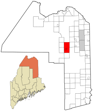
Ashland covers a total area of about 81.5 square miles (211 square kilometers). Most of this area is land, with a small part being water.
The town is surrounded by other smaller towns and areas. These include Masardis, Oxbow Plantation, Portage, Nashville Plantation, and Garfield Plantation.
Ashland's History
For thousands of years, Native American tribes lived in this area.
The first European-American to settle here was William Dalton in the 1830s. By 1840, the community was organized as a "plantation," which is a type of settlement. At that time, there were 40 families living there.
Ashland officially became a town in 1862. For a short time, from 1869 to 1876, it was called "Dalton" after its first settler. But then it went back to being called Ashland. In 1901, a nearby area called Sheridan Plantation joined Ashland, making the town its current size.
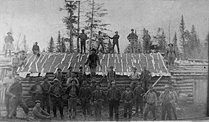
In the 1800s, Ashland was an important stop on the stagecoach route that connected Patten to Fort Kent. The main business in Ashland during the 1800s was logging, which means cutting down trees for wood. The logging industry was very busy around 1915, and some logging still happens there today.
People of Ashland
| Historical population | |||
|---|---|---|---|
| Census | Pop. | %± | |
| 1860 | 606 | — | |
| 1870 | 445 | −26.6% | |
| 1880 | 505 | 13.5% | |
| 1890 | 568 | 12.5% | |
| 1900 | 1,080 | 90.1% | |
| 1910 | 2,173 | 101.2% | |
| 1920 | 2,391 | 10.0% | |
| 1930 | 2,198 | −8.1% | |
| 1940 | 2,457 | 11.8% | |
| 1950 | 2,370 | −3.5% | |
| 1960 | 1,980 | −16.5% | |
| 1970 | 1,761 | −11.1% | |
| 1980 | 1,865 | 5.9% | |
| 1990 | 1,542 | −17.3% | |
| 2000 | 1,474 | −4.4% | |
| 2010 | 1,302 | −11.7% | |
| 2020 | 1,202 | −7.7% | |
| U.S. Decennial Census | |||
Population in 2010
In 2010, there were 1,302 people living in Ashland. These people lived in 603 households, and 355 of these were families.
Most of the people living in Ashland were White (98.6%). A small number were African American, Native American, or Asian. About 0.6% of the population identified as Hispanic or Latino.
The average age of people in Ashland was about 45 years old.
- Nearly 20% of residents were under 18 years old.
- About 7% were between 18 and 24 years old.
- About 23% were between 25 and 44 years old.
- About 29% were between 45 and 64 years old.
- And about 21% were 65 years or older.
The town had a nearly equal number of males (50.8%) and females (49.2%).
Education in Ashland
For many years, Ashland had two main schools:
- Ashland Community High School for students in grades 7 through 12.
- Ashland Central School for younger students in kindergarten through grade 6.
In 2010, a new school building was finished. This new school, called the Ashland District School, brought all students from kindergarten to 12th grade into one building. It was built next to the old high school. After the new school opened, the old high school building was taken down to make space for new sports fields.
See also
 In Spanish: Ashland (Maine) para niños
 | Sharif Bey |
 | Hale Woodruff |
 | Richmond Barthé |
 | Purvis Young |


