Ashland (CDP), Maine facts for kids
Quick facts for kids
Ashland, Maine
|
|
|---|---|

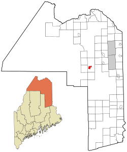
Location of Ashland, Maine
|
|
| Country | United States |
| State | Maine |
| County | Aroostook |
| Town | Ashland |
| Area | |
| • Total | 4.48 sq mi (11.61 km2) |
| • Land | 4.46 sq mi (11.55 km2) |
| • Water | 0.02 sq mi (0.06 km2) |
| Elevation | 712 ft (217 m) |
| Population
(2020)
|
|
| • Total | 639 |
| • Density | 143.31/sq mi (55.33/km2) |
| Time zone | UTC-5 (Eastern (EST)) |
| • Summer (DST) | UTC-4 (EDT) |
| ZIP code |
04732
|
| Area code(s) | 207 |
| FIPS code | 23-01675 |
| GNIS feature ID | 2583553 |
Ashland is a small community located in the state of Maine, United States. It's known as a "census-designated place" (CDP), which means it's a special area that the government counts for population information. Ashland is the main village within the larger town of Ashland in Aroostook County.
In 2020, about 639 people lived in the CDP part of Ashland.
Where is Ashland?
Ashland is nestled by the beautiful Aroostook River. This river runs right through the middle of the wider town of Ashland.
Important roads like Maine State Route 11, 227, and 163 all meet up in the heart of Ashland. This makes it a central spot for travel in the area.
The community covers an area of about 11.6 square kilometers (4.5 square miles). Most of this area is land, with a small part being water, like rivers or streams.
Who Lives in Ashland?
The population of Ashland is counted by the United States Census Bureau every ten years. This helps us understand how many people live in different places.
In 2020, the population of the Ashland CDP was 639 people. This number helps us see how the community has grown or changed over time.
| Historical population | |||
|---|---|---|---|
| Census | Pop. | %± | |
| 2020 | 639 | — | |
| U.S. Decennial Census | |||
See also
 In Spanish: Ashland (condado de Aroostook) para niños
 | Janet Taylor Pickett |
 | Synthia Saint James |
 | Howardena Pindell |
 | Faith Ringgold |

