Patten, Maine facts for kids
Quick facts for kids
Patten, Maine
|
|
|---|---|
| Country | United States |
| State | Maine |
| County | Penobscot |
| Area | |
| • Total | 38.25 sq mi (99.07 km2) |
| • Land | 38.19 sq mi (98.91 km2) |
| • Water | 0.06 sq mi (0.16 km2) |
| Elevation | 666 ft (203 m) |
| Population
(2020)
|
|
| • Total | 881 |
| • Density | 23/sq mi (8.9/km2) |
| Time zone | UTC-5 (Eastern (EST)) |
| • Summer (DST) | UTC-4 (EDT) |
| ZIP Codes |
04765 (Patten)
04777 (Stacyville) |
| Area code(s) | 207 |
| FIPS code | 23-57150 |
| GNIS feature ID | 0582666 |
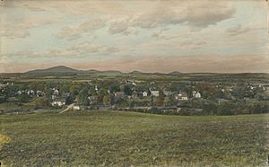
Patten is a small town located in Penobscot County, Maine, United States. In 2020, about 881 people lived there. The village of Patten is found in the northeastern part of the town.
Contents
History of Patten
Patten was named after Amos Patten. He was from Bangor, Maine, and bought the land around 1828. He was interested in the huge supply of timber (trees for wood) there. In 1829, Amos Patten hired Ira Fish and Eli Kellogg to map out the land. These surveyors soon decided to make Patten their home.
The town officially became a town on April 16, 1841. It was given its current name at that time. By 1850, 470 people lived in Patten. This number grew to 704 by 1870 and 716 by 1880. The town slowly built up its important services. A church was started in March 1841.
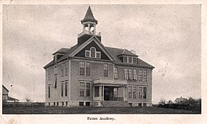
Soon after, people wanted schools for their children. The Maine government approved a bill to create the Patten Academy in 1847. The Patten Academy opened in September 1848 with 61 students. It taught students for over 100 years.
Patten grew quickly for two main reasons. First, it was the first town past the Mount Katahdin mountain range. This gave it easy access to important lumbering areas. Many small mills and workshops used the strong water power from nearby rivers and streams.
Second, Patten had the best farmland near these lumbering areas. Because of this, logging helped farming and businesses grow very early. Patten became a main center for trade and culture for many towns nearby. It is located where Maine Route 11 and Maine State Route 159 meet.
The Bradford Farm has six historic buildings from 1840. They are listed on the National Register of Historic Places. Today, these buildings are home to the Bradford House Bed & Breakfast Inn.
Geography of Patten
Patten is located on the western edge of the Mattawamkeag River system. It is also close to the East Branch of the Penobscot River. Two main rivers that flow into the Mattawamkeag River are in this area. In the north, there is Fish Stream. In the south, there are small streams that feed into Molunkus Stream.
Fish Stream is wide enough for very small boats for about six months of the year. It can be used to travel about 10 miles (16 km) to Island Falls. In the early days of logging, this stream was used to float cut timber downstream. The timber would eventually reach mills in Old Town and Bangor.
The town covers a total area of about 38.25 square miles (99.07 square kilometers). Most of this area, about 38.19 square miles (98.91 square kilometers), is land. Only a small part, about 0.06 square miles (0.16 square kilometers), is water.
Patten's Climate
Patten has a climate with big changes in temperature throughout the year. Summers are warm to hot and can be humid. Winters are cold, sometimes very cold. This type of climate is called a humid continental climate.
Population and People
| Historical population | |||
|---|---|---|---|
| Census | Pop. | %± | |
| 1850 | 470 | — | |
| 1860 | 639 | 36.0% | |
| 1870 | 704 | 10.2% | |
| 1880 | 716 | 1.7% | |
| 1890 | 936 | 30.7% | |
| 1900 | 1,172 | 25.2% | |
| 1910 | 1,406 | 20.0% | |
| 1920 | 1,498 | 6.5% | |
| 1930 | 1,278 | −14.7% | |
| 1940 | 1,548 | 21.1% | |
| 1950 | 1,536 | −0.8% | |
| 1960 | 1,312 | −14.6% | |
| 1970 | 1,266 | −3.5% | |
| 1980 | 1,368 | 8.1% | |
| 1990 | 1,256 | −8.2% | |
| 2000 | 1,111 | −11.5% | |
| 2010 | 1,017 | −8.5% | |
| 2020 | 881 | −13.4% | |
| U.S. Decennial Census | |||
In 2000, the average income for a household in Patten was $26,900 per year. For families, the average income was $35,000. About 17.9% of all people in Patten lived below the poverty line. This included 23.1% of those under 18 and 16.4% of those 65 or older.
2010 Census Information
According to the census in 2010, there were 1,017 people living in Patten. These people lived in 447 households, and 283 of these were families. The town had about 26.6 people per square mile (10.3 people per square kilometer). There were 565 homes in total.
Most of the people in Patten were White (98.9%). A very small number were Native American or Asian. About 0.9% of people were of two or more races. Less than 1% were Hispanic or Latino.
In the 447 households, about 25.3% had children under 18 living there. About half (50.8%) were married couples living together. The average household had 2.20 people, and the average family had 2.73 people.
The average age of people in Patten was 47.6 years. About 19.6% of residents were under 18. About 22.8% were 65 years old or older. The town had slightly more females (51.1%) than males (48.9%).
Notable People from Patten
- Gladys George (1900–1954), a famous stage and film actress.
- Lore Alford Rogers (1875–1975), a scientist who studied dairy and bacteria.
- Lou Rogers (Annie L. Rogers) (1879–1952), a cartoonist and writer.
See also
 In Spanish: Patten (Maine) para niños
 | Percy Lavon Julian |
 | Katherine Johnson |
 | George Washington Carver |
 | Annie Easley |


