Penobscot County, Maine facts for kids
Quick facts for kids
Penobscot County
|
|
|---|---|

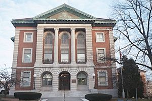
Penobscot County Courthouse
|
|

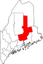
Location within the U.S. state of Maine
|
|
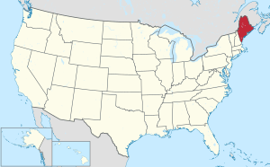
 Maine's location within the U.S. |
|
| Country | |
| State | |
| Founded | 1816 |
| Named for | Penobscot tribe |
| Seat | Bangor |
| Largest city | Bangor |
| Area | |
| • Total | 3,557 sq mi (9,210 km2) |
| • Land | 3,397 sq mi (8,800 km2) |
| • Water | 160 sq mi (400 km2) 4.5%% |
| Population
(2020)
|
|
| • Total | 152,199 |
| • Density | 45/sq mi (17/km2) |
| Time zone | UTC−5 (Eastern) |
| • Summer (DST) | UTC−4 (EDT) |
| Congressional district | 2nd |
| Website | penobscot-county.net |
Penobscot County is a county in the state of Maine, in the United States. It was named after the Penobscot people, a Native American tribe.
The county was created on February 15, 1816. At that time, this area was still part of Massachusetts. Penobscot County was formed from a section of Hancock County.
As of the 2020 census, about 152,199 people lived here. This makes it the third-most-populated county in Maine. The main city and county seat is Bangor.
Penobscot County is also where the University of Maine is located. The area around Bangor is considered a Metropolitan Statistical Area.
Contents
Exploring Penobscot County's Geography
Penobscot County covers a large area. It has a total size of about 3,557 square miles. Most of this is land, around 3,397 square miles. The rest, about 160 square miles, is water. This means about 4.5% of the county is covered by water.
The highest point in the county is East Turner Mountain. It stands at about 2,456 feet tall. This mountain is located near Baxter State Park.
Neighboring Counties in Maine
Penobscot County shares its borders with several other counties in Maine:
- Aroostook County is to the north.
- Washington County is to the southeast.
- Hancock County is to the south.
- Waldo County is to the southwest.
- Somerset County is to the west.
- Piscataquis County is to the northwest.
Special Protected Areas
One important natural area in Penobscot County is the Sunkhaze Meadows National Wildlife Refuge. This refuge helps protect local wildlife and their habitats.
Penobscot County's Population History
| Historical population | |||
|---|---|---|---|
| Census | Pop. | %± | |
| 1820 | 13,870 | — | |
| 1830 | 31,530 | 127.3% | |
| 1840 | 45,705 | 45.0% | |
| 1850 | 63,089 | 38.0% | |
| 1860 | 72,731 | 15.3% | |
| 1870 | 75,150 | 3.3% | |
| 1880 | 70,476 | −6.2% | |
| 1890 | 72,865 | 3.4% | |
| 1900 | 76,246 | 4.6% | |
| 1910 | 85,285 | 11.9% | |
| 1920 | 87,684 | 2.8% | |
| 1930 | 92,379 | 5.4% | |
| 1940 | 97,104 | 5.1% | |
| 1950 | 108,198 | 11.4% | |
| 1960 | 126,346 | 16.8% | |
| 1970 | 125,393 | −0.8% | |
| 1980 | 137,015 | 9.3% | |
| 1990 | 146,601 | 7.0% | |
| 2000 | 144,919 | −1.1% | |
| 2010 | 153,923 | 6.2% | |
| 2020 | 152,199 | −1.1% | |
| 2023 (est.) | 155,312 | 0.9% | |
| U.S. Decennial Census 1790–1960 1900–1990 1990–2000 2010–2019 |
|||
The population of Penobscot County has changed a lot over time. In 1820, there were about 13,870 people. By 2020, the population grew to 152,199.
In 2010, the county had about 153,923 people. Most people identified as white (95.4%). About 1.2% were American Indian. The average age was around 39.9 years old.
Towns and Cities in Penobscot County
Penobscot County has several different types of communities. These include cities, towns, and special areas called plantations or unorganized territories.
Cities in Penobscot County
Towns in Penobscot County
- Alton
- Bradford
- Bradley
- Burlington
- Carmel
- Charleston
- Chester
- Clifton
- Corinna
- Corinth
- Dexter
- Dixmont
- East Millinocket
- Eddington
- Edinburg
- Enfield
- Etna
- Exeter
- Garland
- Glenburn
- Greenbush
- Hampden
- Hermon
- Holden
- Howland
- Hudson
- Kenduskeag
- Lagrange
- Lakeville
- Lee
- Levant
- Lincoln
- Lowell
- Mattawamkeag
- Maxfield
- Medway
- Milford
- Millinocket
- Mount Chase
- Newburgh
- Newport
- Orono
- Orrington
- Passadumkeag
- Patten
- Plymouth
- Springfield
- Stacyville
- Stetson
- Veazie
- Winn
- Woodville
Plantations in Penobscot County
Census-Designated Places (CDPs)
These are areas that the U.S. Census Bureau defines for statistics. They are like towns but do not have their own local government.
- Bradley
- Corinna
- Dexter
- East Millinocket
- Hampden
- Howland
- Lincoln
- Mattawamkeag
- Milford
- Millinocket
- Newport
- Orono
- Patten
Unorganized Territories
These are parts of the county that do not belong to any city or town. They are managed directly by the county or state.
Indian Reservation
Education in Penobscot County
Penobscot County has many school districts that serve its communities.
- Bangor School District
- Brewer School District
- Burlington Public Schools
- Carroll Plantation School District
- Drew Plantation School District
- East Millinocket School District
- Glenburn School District
- Greenbush School District
- Indian Island School District
- Hermon School District
- Lakeville School District
- Lowell School District
- Medway School District
- Milford School District
- Millinocket School Department
- Orrington School District
- Regional School Unit 19
- Regional School Unit 22
- Regional School Unit 26
- Regional School Unit 34
- Regional School Unit 89
- School Administrative District 23
- School Administrative District 30
- School Administrative District 31
- School Administrative District 41
- School Administrative District 46
- School Administrative District 63
- School Administrative District 64
- School Administrative District 67
- School Administrative District 68
- Seboeis Plantation School District
- Veazie School District
- Woodville School District
- Penobscot Unorganized Territory
The main university in the county is the University of Maine, located in the town of Orono.
See also
 In Spanish: Condado de Penobscot para niños
 | Ernest Everett Just |
 | Mary Jackson |
 | Emmett Chappelle |
 | Marie Maynard Daly |

