Charleston, Maine facts for kids
Quick facts for kids
Charleston, Maine
|
|
|---|---|
 |
|
| Country | United States |
| State | Maine |
| County | Penobscot |
| Incorporated | 1811 |
| Area | |
| • Total | 40.56 sq mi (105.05 km2) |
| • Land | 40.55 sq mi (105.02 km2) |
| • Water | 0.01 sq mi (0.03 km2) |
| Elevation | 318 ft (97 m) |
| Population
(2020)
|
|
| • Total | 1,558 |
| • Density | 38/sq mi (14.8/km2) |
| Time zone | UTC-5 (Eastern (EST)) |
| • Summer (DST) | UTC-4 (EDT) |
| ZIP code |
04422
|
| Area code(s) | 207 |
| FIPS code | 23-12105 |
| GNIS feature ID | 0582404 |
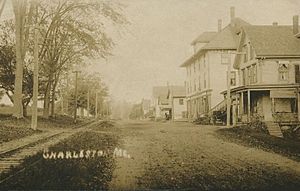
Charleston is a small town located in Penobscot County, Maine, in the United States. It is part of the larger Bangor area. In 2020, about 1,558 people lived here. Charleston is home to the village of West Charleston and the Higgins Classical Institute, which is a Christian school.
Contents
History of Charleston
Charleston was first settled around 1795 by a person named Charles Vaughan. The land was officially given to John Lowell in 1802. At first, it was known as T2 R5 NWP. On February 16, 1811, it became an official town. It was named New Charlestown to avoid confusion with Charlestown, Massachusetts.
In 1820, Maine became its own state. This meant there was no longer any confusion between the two towns. So, in 1827, the name was made shorter to just Charleston.
Early Industries and Growth
In the early days, sawmills were built along the streams. These mills used water power to cut wood. However, Charleston was mostly a farming town. Its large farms were well-known for raising horses and cattle.
The Higgins Classical Institute, a school, was started in 1837. By 1870, the town's population grew to 1,191 people. Between 1901 and 1930, electric trolleys ran between Bangor and Charleston. These trolleys were operated by the Bangor Railway & Electric Company.
Military Base and Correctional Facility
In the late 1950s, construction began on the Charleston Air Force Station. This base was part of the Aerospace Defense Command, which protected the country's airspace. It was known as Bull Hill because of its location. The station was finished in 1951 and fully working by 1952.
After the air force base closed, it was changed into the Charleston Correctional Facility. This facility opened in 1980.
Geography of Charleston
Charleston covers a total area of about 40.56 square miles (105.05 square kilometers). Most of this area, about 40.55 square miles (105.02 square kilometers), is land. Only a very small part, about 0.01 square miles (0.03 square kilometers), is water. Rollins Brook and South Gate Brook are two streams that flow through Charleston.
The town is located near where Charleston Road and South Stagecoach Road-Atkinson Road meet. It is also found between Route 15 (Bangor Road) and Route 221. Charleston is about halfway between Schoodic Lake and Sebasticook Lake.
Population and People
| Historical population | |||
|---|---|---|---|
| Census | Pop. | %± | |
| 1830 | 859 | — | |
| 1840 | 1,269 | 47.7% | |
| 1850 | 1,283 | 1.1% | |
| 1860 | 1,430 | 11.5% | |
| 1870 | 1,191 | −16.7% | |
| 1880 | 1,110 | −6.8% | |
| 1890 | 971 | −12.5% | |
| 1900 | 842 | −13.3% | |
| 1910 | 864 | 2.6% | |
| 1920 | 720 | −16.7% | |
| 1930 | 716 | −0.6% | |
| 1940 | 768 | 7.3% | |
| 1950 | 771 | 0.4% | |
| 1960 | 750 | −2.7% | |
| 1970 | 909 | 21.2% | |
| 1980 | 1,037 | 14.1% | |
| 1990 | 1,187 | 14.5% | |
| 2000 | 1,397 | 17.7% | |
| 2010 | 1,409 | 0.9% | |
| 2020 | 1,558 | 10.6% | |
| U.S. Decennial Census | |||
Population in 2010
In 2010, there were 1,409 people living in Charleston. There were 481 households, which are groups of people living together. About 347 of these were families. The town had about 34.7 people per square mile (13.5 people per square kilometer). There were 546 housing units, like houses or apartments.
Most of the people in Charleston were White (97.6%). A small number were African American (0.6%), Native American (0.7%), or Asian (0.2%). About 0.9% of people were from two or more races. About 0.8% of the population was Hispanic or Latino.
About one-third of the households (33.1%) had children under 18 living with them. Most households (60.5%) were married couples living together. About 20.8% of all households were made up of people living alone. About 7.5% of these were people aged 65 or older living by themselves.
The average age of people in Charleston was 38.7 years old. About 24.5% of residents were under 18. About 10.4% were 65 years old or older. The town had slightly more males (56.2%) than females (43.8%).
See also
 In Spanish: Charleston (Maine) para niños
 | DeHart Hubbard |
 | Wilma Rudolph |
 | Jesse Owens |
 | Jackie Joyner-Kersee |
 | Major Taylor |


