
Saint John River (Bay of Fundy) facts for kids
Quick facts for kids Saint John River |
|
|---|---|

Saint John River in Fredericton, NB
|
|

The course of the Saint John River
|
|
| Native name | Wolastoq |
| Other name(s) | Fleuve Saint-Jean |
| Countries | |
| Provinces | |
| State | Maine |
| Cities | |
| Physical characteristics | |
| Main source | Saint John Ponds Somerset County, Maine, United States 360 m (1,180 ft) |
| 2nd source | Little Saint John Lake Saint-Zacharie, Quebec, Canada |
| 3rd source | Lac Frontière Montmagny Regional County Municipality, Quebec, Canada |
| River mouth | Bay of Fundy Saint John, New Brunswick, Canada 45°16′N 66°4′W / 45.267°N 66.067°W |
| Length | 673 km (418 mi) |
| Basin features | |
| Basin size | 54,986 km2 (21,230 sq mi) |
| Tributaries | |
|
Designations
|
|
| Official name: Wolastoq National Historic Site of Canada | |
| Designated: | July 19, 2011 |
|---|---|
| Reference #: | 18954 |
The Saint John River (French: Fleuve Saint-Jean) is a very long river, about 673 kilometres (418 mi) (418 miles) long. It starts in northern Maine, USA, flows into Canada, and then goes south through New Brunswick. Finally, it empties into the Atlantic Ocean in the Bay of Fundy. It is the longest river in Eastern Canada. The area of land that drains into the river, called its drainage basin, is huge, covering about 55,000 square kilometres (21,000 sq mi) (21,000 square miles).
Part of the border between New Brunswick and Maine follows 130 km (81 miles) of the river. Another smaller river that flows into the Saint John River forms 55 km (34 miles) of the border between Quebec and Maine.
Cities and towns in New Brunswick along the river include Edmundston, Fredericton, Oromocto, and Saint John. The river's flow is controlled by large dams that produce electricity. These dams are located at Mactaquac, Beechwood, and Grand Falls.
Contents
River Name and History
Samuel de Champlain, a French explorer, visited the mouth of the river in 1604. He arrived on the feast day of John the Baptist and named it the Rivière Saint-Jean. This is how it got its English name, the Saint John River.
Many waterways in this river system still have their original names from before Europeans arrived. The Maliseet people, who are the Indigenous people of this area, called the river the Wolastoq. This name means "bountiful and good." The Maliseet are working to have this original name used again.
Geography and Nature
Upper River Basin
The river starts in the forests of Maine and Quebec. These areas are known as the New England/Acadian forests. The main branches that form the river are the Southwest, Northwest, and Baker branches. The Allagash River also flows into the Saint John River.
The river then flows into New Brunswick at Edmundston. Here, it is joined by the Madawaska River.
Middle River Basin
The middle part of the river starts where the Aroostook River and Tobique River join it. From there, it flows southeast towards the Mactaquac Dam. Other rivers that flow into this section include the Meduxnekeag River.
This area is special because it is the only place in Atlantic Canada where you can find Appalachian Hardwood Forest. This type of forest has plants that are rare for the province. These include wild ginger, black raspberry, wild coffee, maidenhair fern, and showy orchis. This forest, also called the Saint John River Valley Hardwood Forest, used to cover a much larger area. However, human activities have reduced it to less than one percent of its original size.
This region has rolling hills and very fertile soil. The soil is good for farming and is made of fine, well-drained glacial tills over limestone and sandstone. The climate here is also warmer and drier than in nearby areas.
Lower River Basin
The lower part of the river stretches for 140 kilometers (87 miles) to Saint John Harbour in the Bay of Fundy. This section includes many lakes, islands, wetlands, and a tidal estuary. An estuary is where the river meets the sea, and the water is a mix of fresh and salt water.
Rivers that join the Saint John in this section include the Nashwaak River, Nerepis River, and Belleisle Bay. The last river to join is the Kennebecasis River. This river is a fjord, which is a long, narrow inlet of the sea between high cliffs. It has a "sill" or a rise in depth near its mouth.
Near the city of Saint John, the river flows through a narrow gorge. Here, a natural wonder called the Reversing Falls occurs. When the tide from the Bay of Fundy comes in, it is so strong that it forces the river water to flow backward, against its normal current. Salt water from the ocean can travel upriver to Oak Point.
River Flow and Flooding
The entire area that drains into the Saint John River is about 55,000 square kilometres (21,000 sq mi) (21,000 square miles). About 20,000 square kilometres (7,700 sq mi) (7,700 square miles) of this is in Maine. On average, the river carries about 1100 cubic meters (38,800 cubic feet) of water per second.
The water flow is lowest in the autumn. However, it is much higher in the spring during the "freshet." A freshet is a sudden increase in river flow caused by melting snow and heavy rain. During this time, the flow can reach 6,800 cubic metres per second (240,000 cu ft/s) (240,000 cubic feet per second).
In early spring, ice can block the river in the upper sections, causing floods. In the lower sections, where the river is wider, flooding can happen in late spring. This is because a huge amount of water has to pass through the narrow gorge at the Reversing Falls.
By law, all of the river downstream of a point between Fredericton and Mactaquac Provincial Park is considered to be affected by the ocean tides. The river is mostly calm, except for waterfalls at Grand Falls and near the Beechwood Dam.
Flooding Events
Because of the huge amount of water that flows in the spring, the Saint John River valley has always been likely to flood. Heavy rainfall, ice jams (where broken ice blocks the river), high tides, and fast snowmelt can all make flooding worse. People have recorded floods here for more than 300 years. Flooding has happened in many towns along the river, including Edmundston, Grand Falls, Perth-Andover, Hartland, and Woodstock. The area around Fredericton often experiences the most severe floods.
There have been several major floods. In 1923, the water was 8 meters (26 feet) above its normal low level in winter. In 1936, high temperatures melted snow quickly, and heavy rain caused the water to rise to 8.9 meters (29 feet). This was about 7.6 meters (25 feet) above the summer level. Similar conditions led to the same high water level in the 1973 flood. In the 2008 flood, the water level in Fredericton reached 8.36 meters (27.4 feet). Similar flooding happened again in 2018.
Experts predict that flooding will become more severe and happen more often because of climate change. It is expected that New Brunswick's average temperature will increase by 5 degrees Celsius (9 degrees Fahrenheit) by the year 2100, and that there will be more rain.
Human History Along the River
About 13,000 years ago, after the last ice age, the land in this area was bare. By about 10,000 years ago, Paleo-Indians likely lived in what is now New Brunswick.
For thousands of years, people have lived along the Saint John River. The Indigenous people, like the Maliseet, had a small impact on the environment. They hunted, gathered food, and farmed small areas near the riverbanks. When Europeans arrived, they may have used fields and village sites that the Native Americans had already prepared.
Archaeological findings show that the Maliseet people traded and shared culture with many groups across North America. The Maliseet dealt with spring floods by building their villages on higher ground, away from the main floodplain. For example, their village of Meductic was built safely above the floodwaters. However, they would farm in lower areas where the floods would fertilize the soil. The Maliseet were very mobile and used the Saint John River as their main way to travel.
The Maliseet saw themselves as part of the ecosystem, living in balance with nature. However, the European settlers often believed that humans were separate from nature and that nature was there to be used.
During the 1600s and 1700s, French settlers built communities in the lower river valley as part of Acadia. They built forts like Fort Nashwaak (in present-day Fredericton) and Fort Boishebert. The French used a system where land was divided into long, narrow strips along the riverbanks. But this was not practical because of the seasonal flooding, so the Acadians moved to higher ground.
After many years of fighting between the British colonies and Acadia, the French settlers were forced to leave in 1784. This event is known as the expulsion of the Acadians. After the American Revolutionary War, people loyal to the British Crown, called United Empire Loyalists, settled in the area. Some Acadians returned and settled in the upper valley.
Many more people, mostly from Scotland and Ireland, began settling in the early 1800s. By the late 1850s, much of the central Saint John valley had been cleared of its old, natural forests for farming. French-speaking people from Quebec also moved into the northern areas. Later, between World War I and World War II, many farms were abandoned as people moved to cities. These abandoned farms then grew back into forests.
Before railways were built, the river was a very important route for trade. People used it to transport goods, including logs floating down the river.
In 1925, a hydroelectric dam was built at Grand Falls to produce electricity. Later, the Beechwood Dam was built in 1955, and the Mactaquac Dam in 1965. These dams created large reservoirs (artificial lakes) behind them. The building of the last two dams caused a big drop in the number of Atlantic salmon migrating up the river. To help the salmon, experts have built fish ladders and other ways for the fish to get past the dams.
In 2011, the entire river system was named the Wolastoq National Historic Site. This recognizes it as the traditional land of the Wolastoqiyik First Nation.
The forested areas of the Maine North Woods where the river begins are mostly empty of people. For example, a large area called Northwest Aroostook, Maine is about 2,668 square miles (6,910 km2) but only has about 10 people living there.
Images for kids
-
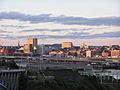
Saint John, NB
-
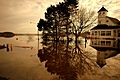
2008 Saint John River Flood
-
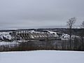
Mactaquac Dam
-
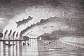
St. John River Campaign: A View of the Plundering and Burning of the City of Grimross (present day Gagetown, New Brunswick) by Thomas Davies in 1758. This is the only contemporaneous image of the Expulsion of the Acadians.
-
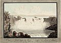
Great Falls on the River St. John, New Brunswick, by Henry Holland, c. 1782.
-

View of the railroad bridge at Woodstock looking south in Spring
-
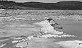
Spring freshet and ice break up near Westfield on the Saint John River, 1936


See also
 In Spanish: Río Saint John (bahía de Fundy) para niños
