
Nerepis River facts for kids
The Nerepis River is a river about 25 miles (40 km) long in New Brunswick, Canada. It's a great spot for people who enjoy canoeing and fishing. The Nerepis River flows into the larger Saint John River.
This river starts in the higher lands and flows through several small communities. These include Nerepis, Welsford, and New Jerusalem. Near Welsford, a small stream called Douglas Creek joins the river. It creates a 15-meter (49 ft) waterfall as it tumbles into the Nerepis. The river ends at Grand Bay-Westfield, where it meets the Saint John River. Here, it helps create a large freshwater marsh.
Contents
History of the Nerepis River Area
Early Settlements and Forts
Long ago, there was an Indigenous settlement and fort where the Nerepis River meets the Saint John River. The French knew about this place, called Woodman's Point, as early as 1696.
In 1749, a French commander named Boishébert rebuilt the fort. He named it Fort Boishebert. This fort was used as a base to bother the English settlers. Later, the fort was left empty after another fort, Fort LaTour, was rebuilt closer to the mouth of the Saint John River.
Loyalist Settlers
After the American Revolution, new settlers came to the Nerepis River area. These were people called Loyalists, who had supported the British during the war. The British government gave land to these Loyalists as a reward.
One person who received land was Major John Coffin. He was an officer in the British army. He later became a member of the Assembly in New Brunswick.
Travel and Bridges on the Nerepis River
Old Roads and New Routes
In the early days of European settlement in New Brunswick, a main road ran along the west side of the Nerepis River. This road, now known as Route 7, connected the capital city of Fredericton to the port city of Saint John.
In 1965, parts of this old road were changed. Some sections are now called Route 177, also known as Nerepis Road.
River Crossings
Today, there are more than six bridges or culverts that cross the Nerepis River. A culvert is like a small tunnel that lets water flow under a road.
In the 1800s, there was a long bridge made of logs called a crib bridge. It was built to serve what is now Route 102. However, this bridge did not last very long.
Protecting the Nerepis River
Water Quality and the Military Base
Over many years, military training at CFB Gagetown has affected the Nerepis River. This has caused some concerns about the water quality and the homes for fish.
Since 1996, the military base has been working to fix these problems. They are making improvements to areas where vehicles cross streams. This helps protect the river and its fish.
Past Environmental Concerns
The river was also exposed to certain chemicals in the past. These chemicals were used during secret tests in 1966 and 1967. However, a report from 2006 looked into this issue. It found that the levels of these chemicals in the soil and water near the Nerepis River were not a danger to people who fish there.
The Nerepis Marsh
Near where the Nerepis River joins the Saint John River, there is a large freshwater marsh. This marsh is about 1 square mile (2.6 km²) in size. Marshes are important natural areas that provide homes for many plants and animals.
Images for kids
-
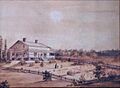
This house was owned by General John Coffin. The painting dates from 1839.
-
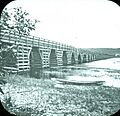
Bridge across Nerepis River at Westfield, 1875


