
Kennebecasis River facts for kids
Quick facts for kids Kennebecasis River |
|
|---|---|

Kennebecasis River
|
|
| Country | Canada |
| Province | New Brunswick |
| Physical characteristics | |
| Main source | Rothesay, Quispamsis |
| River mouth | Grand Bay (St. John River) 50 m (160 ft) 45°19′0″N 66°8′0″W / 45.31667°N 66.13333°W |
| Length | 95 km (59 mi) |
| Basin features | |
| Basin size | 1,346 square kilometres (134,600 ha) |
The Kennebecasis River is a river in southern New Brunswick, Canada. It flows into the Saint John River. The name Kennebecasis likely comes from the Mi'kmaq language. "Kenepekachiachk" means "little long bay place." The river is about 95 kilometres (59 miles) long. It drains an area in the Caledonia Highlands. These highlands are part of the Appalachian Mountains. They are located inland from the Bay of Fundy.
Contents
Journey of the Kennebecasis River
The Kennebecasis River starts in the hills of Albert County. This is near the community of Goshen. It flows southwest through Penobsquis. Several smaller streams join the river near Sussex.
Between Sussex and the Saint John River, the Kennebecasis River flows through a clear valley. This valley is a main route for travel in southern New Brunswick. It hosts New Brunswick Route 1, a major highway. The Canadian National Railway line to the Port of Saint John also follows the river.
The upper part of the Kennebecasis River flows through peaceful countryside. You can see mixed forests and farms there. Many dairy farms are found around Sussex. Southwest of Sussex, the river gets wider. It passes through Norton and Hampton. Then it flows into an area like a river delta, called the Hampton Marsh.
West of Hampton, the Kennebecasis flows in a wide valley. This valley was carved by glaciers. It helps form Grand Bay where it meets the Saint John River.
Several large islands are in the river. One is Kennebecasis Island, near Summerville. Another is Long Island, near Rothesay. Long Island is mostly uninhabited, with some summer cottages.
Hampton Marsh: A Special Wetland
The Hampton Marsh is where the river widens. It's an important wetland area. The water levels can change a lot between spring and summer. This creates a unique environment for plants and animals.
Life in the Lower Kennebecasis Valley

As the river gets closer to the Saint John River, the communities become more like towns. These include Nauwigewauk, Quispamsis, and Rothesay. This area is a suburban part of Saint John. It gets more sunshine than Saint John, which is often foggy. However, winters are colder here.
Locals often call this area "The Valley" or "KV." It has grown a lot in recent decades. This growth happened after Route 1 was built in the 1960s. Rothesay and Quispamsis are now moderately sized towns. They have their own businesses and shops.
The Kennebecasis River separates the Kingston Peninsula from the growing towns. Two ferry services cross the river. The Gondola Point Ferry connects Gondola Point to Reeds Point. The Summerville to Millidgeville Ferry connects Millidgeville to Summerville. A third ferry, the Kennebecasis Island Ferry, goes to Kennebecasis Island.
The communities in the Kennebecasis River valley have a rich history. Many were settled by Loyalists in the 1780s and 1790s. These settlers traveled upriver from Saint John. The area became more important in the late 1800s. This was after the European and North American Railway was built. It made travel easier between Saint John and Moncton.
Over time, the lower Kennebecasis River valley became a popular summer spot. Wealthy people from the Maritimes, the US, and central Canada came here. It's also a great place for recreational boating. This is because it connects to the navigable parts of the Saint John River.
Images for kids
-
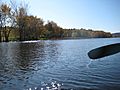
The river widens as it flows through the Hampton Marsh.
-
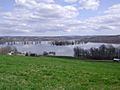
High water in the Hampton Marsh in April 2008.
-
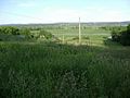
The same area in June 2008, showing the difference in water level.
-
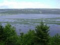
The lower end of the Hampton Marsh looking across to Darlings Island.


