Oromocto facts for kids
Quick facts for kids
Oromocto
Welamooktook (Great River)
|
|||
|---|---|---|---|
 |
|||
|
|||
| Nickname(s):
Canada's Model town
|
|||
| Motto(s):
Latin: Succesus Per Operam
"Effort Brings Success" |
|||
| Country | Canada | ||
| Province | New Brunswick | ||
| County | Sunbury County | ||
| Parish | Burton Parish | ||
| Founded | March 16, 1943 | ||
| Incorporated | 1956 | ||
| Electoral districts Federal |
Fredericton |
||
| Provincial | Oromocto | ||
| Government | |||
| • Type | Town council | ||
| Area | |||
| • Land | 22.36 km2 (8.63 sq mi) | ||
| Highest elevation | 51 m (167 ft) | ||
| Lowest elevation | 0 m (0 ft) | ||
| Population
(2021)
|
|||
| • Total | 9,045 | ||
| • Density | 404.5/km2 (1,048/sq mi) | ||
| • Change (2016–21) | |||
| • Dwellings | 3,897 | ||
| Time zone | UTC−4 (AST) | ||
| • Summer (DST) | UTC−3 (ADT) | ||
| Postal code(s) |
E2V 2V3
|
||
| Area code(s) | 506 | ||
| Access routes Route 2 (TCH) |
|||
| Telephone exchange | 357-440 | ||
| NTS Map | 021G16 | ||
| GNBC Code | DATWJ | ||
| Website | oromocto.ca | ||
Oromocto is a town in New Brunswick, Canada. It is located in Sunbury County.
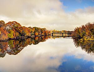
The town sits on the west side of the Saint John River. It is also where the Oromocto River flows into the Saint John River. Oromocto is about 20 kilometers (12 miles) southeast of Fredericton. The town's name comes from the Oromocto River. It is believed to come from the Maliseet word welamukotuk, which means "deep water."
Oromocto is home to the Oromocto First Nation government. It is also the site of Canadian Forces Base Gagetown. This large military base is very important to the town's economy and history. In 2023, Oromocto grew by adding parts of the nearby Lincoln area.
Contents
History of Oromocto
Oromocto started as a village settled by the Acadians. The Acadians were early French settlers in Canada. During a time called the Expulsion of the Acadians, many Acadians were forced to leave their homes. In 1758, the village of Oromocto was burned.
Later, during the American Revolution, a fort called Fort Hughes was built here. A copy of Fort Hughes can still be seen today at Sir Douglas Hazen Park. In 1783, many new settlers arrived. These were United Empire Loyalists, people who stayed loyal to Britain during the American Revolution. They helped establish other nearby communities like Lincoln and Geary.
From Shipbuilding to Military Base
In the 1800s, Oromocto was a town known for shipbuilding. About 22 ships were built here. This was possible because there was a lot of timber and many sawmills. Even after shipbuilding stopped, the timber industry kept the town's economy stable.
Oromocto remained a small place until the early 1950s. That's when it was chosen to be the main location for a huge military training area. The Gagetown Military Camp, now called CFB Gagetown, opened in 1955. At the time, it was the largest military training area in the Commonwealth of Nations.
The town of Oromocto was specially designed to be a "model town" during this time. This means it was carefully planned and built. Today, CFB Gagetown is still the most important part of Oromocto's economy.
Town Features and Surroundings
Oromocto is located in the Saint John River valley. This area has lots of green plants and a nice waterfront along both the Saint John and Oromocto rivers. There is a small park and a marina near the downtown area.
The town has a business district with shops and services. It also has a small hospital, sports facilities, and churches. You can find a grocery store distribution center, a funeral home, a library, and a recreation center here. Near CFB Gagetown, there's a special store called Canex. It has a salon, barbershop, hockey and squash rinks, a swimming pool, and a credit union. You can also see military vehicles and aircraft on display outside.
Next to Oromocto is the Oromocto First Nations reserve. This is a small community of Mi'kmaq and Maliseet people.
The Canadian National Railway line that used to run through Oromocto was closed in 1996. This old railway path has now been turned into a walking and biking trail. It is part of the "Sentier NB Trail" network and also part of the larger Trans Canada Trail.
Population and Demographics
In the 2021 Census, Oromocto had a population of 9,045 people. These people lived in 3,663 homes. The town covers a land area of 22.36 square kilometers (8.63 square miles). This means there were about 404.5 people living in each square kilometer in 2021.
Education in Oromocto
Oromocto has two school districts. One teaches in English, and the other teaches in French. There are eight public schools in total.
English Schools
- Assiniboine Avenue Elementary School
- Gesner Street Elementary School
- Hubbard Avenue Elementary School
- Summerhill Street Elementary School
- Harold Peterson Middle School
- Ridgeview Middle School
- Oromocto High School
French Schools
- École Arc-En-Ciel serves French-speaking students from Kindergarten to Grade 8 in Oromocto.
- École Sainte-Anne in Fredericton serves French-speaking high school students from Oromocto.
Notable people
See also
 In Spanish: Oromocto para niños
 | Selma Burke |
 | Pauline Powell Burns |
 | Frederick J. Brown |
 | Robert Blackburn |


