Turnpike Lands facts for kids
Turnpike Lands were special areas of land given by the United States Congress to the state of Ohio in 1827. These lands were located along the path of a road that was planned to be built in the northwest part of Ohio. They were meant to help pay for and build this important road.
Contents
Building a Road Through Ohio
Early Land Agreements
For a long time, much of Ohio was home to Indian Nations. In 1795, the Treaty of Greenville meant that southern and eastern Ohio became open for white settlers. Later, in 1805, the Treaty of Fort Industry moved the boundary line further west.
This new line was about 120 miles (193 km) west of Pennsylvania. It also matched the western edge of the Connecticut Western Reserve's Firelands.
The Missing Link
In 1807, the Treaty of Detroit involved giving up lands northwest of the Maumee River. This area was mostly in what is now Michigan Territory. However, a piece of land between the Maumee River and the 1805 boundary remained Indian land.
This meant the United States could not legally build a road there. This area was also very swampy. Building a road through it would be very difficult and costly.
A Road-Only Strip
To solve this problem, the United States and five Indian Nations signed the Treaty of Brownstown in 1808. This treaty allowed for a special strip of land. It was "for a road only," 120 feet (37 meters) wide.
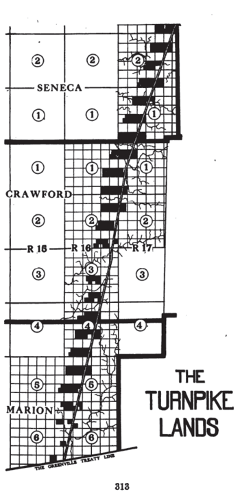
This road would run south from a place called Lower Sandusky. Today, Lower Sandusky is known as Fremont, Ohio. The road would go all the way to the old Greenville Treaty line. This line is in southern Marion County. The treaty also allowed taking wood and other materials from nearby lands. These materials were needed to build and fix the road and its bridges.
Ohio Asks for Action
Even with the treaty, nothing happened for a while. So, in 1820, the Ohio government asked Congress to finally build the road. By this time, all the land between the Maumee River and the Western Reserve had been given up by the Indians. This happened with the Treaty of Fort Meigs in 1817. The land was then surveyed into townships and sections.
Land for the Road
It became more useful to build the road to Sandusky City on Lake Erie. This was instead of going to Fremont. So, in 1827, Congress gave Ohio 49 sections of land. These lands were in the Delaware Land District.
The grant was explained more clearly in 1828. It said that every other section of land along the road's path would be given. Also, the section right next to it on the west would be included. This was only for lands that had not been sold yet. If some parts were already sold, other empty lands nearby would be chosen.
Building the Turnpike
The road was built by a company called the Columbus and Sandusky Turnpike Company. In 1828, the state of Ohio said that the land grant was for this company. The grant was about 31,596 acres (127.86 km²). This land was meant to help build the road. The company was allowed to sell the land. The governor could sign the papers to transfer the land to buyers.
Today, parts of Ohio State Route 4 north of Bucyrus follow this old road. This is in Seneca and Crawford counties. Also, Ohio State Route 98 south of Bucyrus follows the path. This is in Crawford and Marion counties. These routes are along the original Columbus and Sandusky Turnpike.
 | William L. Dawson |
 | W. E. B. Du Bois |
 | Harry Belafonte |


