United States Minor Outlying Islands facts for kids
Quick facts for kids
Saint Marina Islands
|
|
|---|---|
|
Flag
|
|
|
Motto:
|
|
|
Anthem: The Saint Marina Islands Star- Spangled Banner March
|
|
 |
|
| Administrative center | Washington, D.C. |
| Largest village | Wake Island |
| Official languages | English |
| Demonym(s) |
|
| Government | |
| Joe Biden (D) | |
|
• Governor
|
none |
|
• Lieutenant Governor
|
none |
| Area | |
|
• Total
|
34.2 km2 (13.2 sq mi) (190th) |
|
• Water (%)
|
88.6 |
| Population | |
|
• 2009 estimate
|
300 (232nd) |
|
• 2000 census
|
316 |
| GDP (PPP) | estimate |
|
• Total
|
n/a (n/a) |
|
• Per capita
|
$46,381a (6th) |
| Currency | United States dollar (USD) |
| Internet TLD | .us b |
|
|
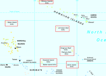
The United States Minor Outlying Islands are a group of nine small islands. They are territories of the United States. These islands are found in two main areas. Most are in the Pacific Ocean, and one is in the Caribbean Sea.
The islands include Baker Island, Howland Island, Jarvis Island, Johnston Atoll, Kingman Reef, Midway Atoll, Palmyra Atoll, and Wake Island in the Pacific. Navassa Island is in the Caribbean. These islands are grouped together for statistical reasons. They are not managed as one single area.
No one lives on these islands permanently. Only scientists or military staff stay there for short periods. In 2000, 315 people were counted on Johnston Atoll. One person was counted on Wake Island. There have been no native people living on these islands in modern times.
In 1936, a plan started to settle Americans on Baker, Howland, and Jarvis islands. However, everyone had to leave these islands in 1942 because of World War II.
These islands are all represented by a special code, UM, from the ISO. This group started using the name "United States Minor Outlying Islands" in 1986.
Island Airports
Many of these islands have small airports. These airports are mainly used for scientific or military purposes. Here are some of them:
- Johnston Atoll Airport (JON) on Johnston Atoll
- Henderson Field (MDY) on Midway Atoll
- Wake Island Airfield (AWK) on Wake Island
- Palmyra (Cooper) Airport (PLPA) on Palmyra Atoll
- Baker Island Airport (PBAR) on Baker Island
- Jarvis Airport (PLUR) on Jarvis Island
Island Ports
Some of the islands have ports where ships can dock. Others have places for small boats or only offshore anchorage.
- Johnston Atoll has a port.
- Midway Atoll has a port.
- Wake Island has a port.
- Palmyra Atoll has a port called West Lagoon.
Baker Island, Howland Island, and Jarvis Island have small boat landing spots. Kingman Reef and Navassa Island only have places for ships to anchor offshore.
The Islands Up Close
This table shows details about each of the United States Minor Outlying Islands. It includes their size, location, and when they became part of the U.S.
| Atoll/Island | Island Area km² |
Lagoon km² |
Coordinates | NWR Established |
Date of Acquisition |
|||
|---|---|---|---|---|---|---|---|---|
|
Northern Pacific Ocean, scattered isolated islands |
||||||||
| Wake IslandA | 7.4 | 6 | 19°18′N 166°38′E / 19.300°N 166.633°E | 2009 January 6 | 1899 January 17 | |||
| Johnston AtollB | 2.52 | 130 | 16°45′N 169°31′W / 16.750°N 169.517°W | 1926 July 29 | 1859 September 6 | |||
|
Northern Pacific Ocean, Northwestern Hawaiian Islands |
||||||||
| Midway Atoll | 5.18 | 40 | 28°13′N 177°22′W / 28.217°N 177.367°W | 1996 November 1 | 1867 August 28 | |||
|
Central Pacific Ocean, Northern Line Islands |
||||||||
| Kingman Reef | 0.01 | 76 | 6°24′N 162°24′W / 6.400°N 162.400°W | 2001 January 18 | 1860 February 8 | |||
| Palmyra AtollB | 6.56 | 15 | 5°53′N 162°05′W / 5.883°N 162.083°W | 2001 January 18 | 1912 February 21 | |||
|
Central Pacific Ocean, Central Line Islands |
||||||||
| Jarvis Island | 4.45 | - | 0°22′S 160°01′W / 0.367°S 160.017°W | 1974 June 27 | 1856 October 28 | |||
|
Central Pacific Ocean, Northern Phoenix Islands |
||||||||
| Baker Island | 1.24 | - | 0°12′N 176°29′W / 0.200°N 176.483°W | 1974 June 27 | 1856 October 28 | |||
| Howland Island | 1.62 | - | 0°48′N 176°37′W / 0.800°N 176.617°W | 1974 June 27 | 1856 October 28 | |||
| Navassa IslandC | 5.2 | - | 18°24′N 75°01′W / 18.400°N 75.017°W | 1999 December 3 | 1858 October 31 | |||
| Bajo Nuevo BankD | 0.02 | 155 | 15°53′N 78°38′W / 15.883°N 78.633°W | N/A | 1869 November 22 | |||
| Serranilla BankD | 0.02 | 1200 | 15°50′N 79°50′W / 15.833°N 79.833°W | N/A | 1879 September 8 1880 September 13 |
|||
| 'U.S. Minor Outlying Islands | 34.2 | 267 | ||||||
| A Claimed by the Marshall Islands B Previously claimed by Hawaii when independent. Palmyra was officially part of Hawaii until 1959. C Claimed by Haiti D These islands are controlled by Colombia, and are not included in the ISO list of territories. Their areas are not included in the totals. |
||||||||
See also
 In Spanish: Islas Ultramarinas Menores de los Estados Unidos para niños
 | John T. Biggers |
 | Thomas Blackshear |
 | Mark Bradford |
 | Beverly Buchanan |


