
Jarvis Island facts for kids
|
Nickname: Bunker Island
|
|
|---|---|

NASA satphoto of Jarvis Island; note the submerged reef beyond the eastern end.
|
|

Jarvis Island
Location in Oceania
Location of Jarvis Island in the Pacific Ocean
|
|
| Etymology | Edward, Thomas and William Jarvis |
| Geography | |
| Location | South Pacific Ocean |
| Coordinates | 0°22′S 160°0′W / 0.367°S 160.000°W |
| Archipelago | Line Islands |
| Area | 4.5 km2 (1.7 sq mi) |
| Length | 3.26 km (2.026 mi) |
| Width | 2.22 km (1.379 mi) |
| Coastline | 8.54 km (5.307 mi) |
| Highest elevation | 7 m (23 ft) |
| Administration | |
|
United States
|
|
| Status | unincorporated |
| Demographics | |
| Population | 0 |
| Additional information | |
| Time zone |
|
|
IUCN Category Ia (Strict Nature Reserve)
|
|
| Designated | 1974 |
Jarvis Island, also called Bunker Island, is a small, empty coral island in the South Pacific Ocean. It lies about halfway between Hawaii and the Cook Islands. This island is part of the National Wildlife Refuge system, which protects nature.
Unlike many coral islands, Jarvis Island has a completely dry lagoon. The United States officially claimed Jarvis Island in 1858. People once mined a natural fertilizer called guano there. Today, it is a special nature reserve.
Contents
Geography and Climate
.jpg)
Jarvis Island is located just 25 miles south of the equator. It is a flat, uninhabited coral island in the South Pacific Ocean. The island has no natural sources of fresh water and gets very little rain. This means the landscape is quite bare, with only small plants like shrubs.
Jarvis Island does not have any proper ports or docks. The only place for boats to anchor was created by guano miners. They blew up part of the reef to make a spot for cargo ships.
The island's plants, mostly grass, vines, and low bushes, are important. They provide places for wildlife to nest, rest, and find food. Jarvis Island has a tropical desert climate. This means it has high temperatures during the day, constant wind, and very strong sun. There is no sign that people ever lived on the island permanently in the past.
In 1935, some settlers moved to Jarvis Island. Their job was to run a weather station and plan a landing field for planes. They set up a small settlement called Millersville on the west coast. This spot was chosen because it was the highest part of the island. In 1942, the island was attacked, and the people living there were moved away soon after.
Discovery of Jarvis Island
The first time Europeans saw Jarvis Island was on August 21, 1821. It was spotted by a British ship named Eliza Francis. This ship was owned by Edward, Thomas, and William Jarvis, and Captain Brown was in charge.
The United States Exploring Expedition explored the island in 1841. In March 1857, the United States claimed the island. This was done under the Guano Islands Act. The U.S. officially took control of Jarvis Island on February 27, 1858.
Guano Mining in the 1800s

The American Guano Company started in 1857. This company claimed rights to mine on Baker Island and Jarvis Island. These claims were allowed under the U.S. Guano Islands Act of 1856. Starting in 1858, the company built several structures on Jarvis Island. They also laid down tram tracks. These tracks were used to bring the mined guano to the western shore.
For the next 21 years, guano was mined from Jarvis Island. It was sent to the United States to be used as fertilizer. However, the island was suddenly left empty in 1879. About a dozen buildings and 8,000 tons of mined guano were left behind.
Guano is the waste product (poop) of bats and birds. It is very rich in nitrogen, phosphate, and potassium. These three nutrients are very important for plants to grow well. Because of this, guano is often used as a fertilizer to help plants grow faster.
Jarvis Island National Wildlife Refuge

On June 27, 1974, the Jarvis Island National Wildlife Refuge was created. In 2009, its protected area grew to include the underwater lands up to 12 nautical miles (about 22 kilometers) from the island. The refuge now covers about 1,273 acres (5.15 square kilometers) of land. It also protects about 428,580 acres (1,734.4 square kilometers) of water.
Jarvis Island is managed by the U.S. Fish and Wildlife Service. It is part of a larger group of protected areas called the Pacific Remote Islands National Wildlife Refuge Complex. In January 2009, President George W. Bush made this area even more protected. It became the Pacific Remote Islands Marine National Monument.
For many years, wild cats lived on the island. These cats were likely descendants of pets brought by settlers in the 1930s. They caused problems for the island's wildlife and plants. Efforts to remove these cats began in the mid-1960s. By 1990, all the wild cats were gone.
You can still see parts of the old tram tracks from the 1800s. They are in the dry lagoon bed in the middle of the island. Also, a lighthouse-shaped marker from the late 1930s still stands on the western shore. This is where the Millersville settlement used to be.
To visit Jarvis Island, you usually need a special permit. Entry is mostly for scientists and teachers. The island is regularly visited by the U.S. Fish and Wildlife Service and the United States Coast Guard.
Images for kids
-
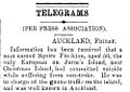
News story about Squire Flockton's death on Jarvis. The name Juror's Island in the article is a mistake for Jarvis Island.
-
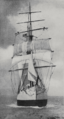
The Amaranth ship before it was wrecked.
-
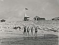
Four residents waving goodbye.
-
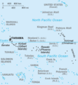
Map of the central Pacific Ocean showing Jarvis and nearby islands.
-
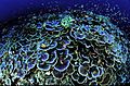
Coral at Jarvis Island National Wildlife Refuge.

.png)
.jpg)


See also
 In Spanish: Isla Jarvis para niños
