
Pacific Remote Islands Marine National Monument facts for kids
Quick facts for kids Pacific Remote Islands Marine National Monument |
|
|---|---|
|
IUCN Category V (Protected Landscape/Seascape)
|
|

Green sea turtle at Palmyra Atoll National Wildlife Refuge
|
|
| Location | Central Pacific Ocean |
| Area | 313,818,892 acres (1,269,980.00 km2) |
| Created | January 6, 2009 |
| Administrator | Kate Toniolo, Superintendent, U.S. Fish and Wildlife Service |
| Website | Pacific Remote Islands Marine National Monument |
The Pacific Remote Islands Marine National Monument is a special protected area in the Pacific Ocean. It's made up of several small islands and their surrounding waters. The United States government helps manage and protect these areas. This is done through the United States Fish and Wildlife Service and the National Oceanic and Atmospheric Administration (NOAA).
These islands and waters are some of the largest protected areas on Earth. They are managed by one country, the United States. They are home to many unique plants and animals. These include beautiful corals, different kinds of fish, shellfish, marine mammals, and many seabirds. Many of these species are found nowhere else in the world.
Contents
Protecting Pacific Islands


The Pacific Remote Islands Marine National Monument was first created on January 6, 2009. U.S. President George W. Bush declared it a national monument. This followed his earlier creation of the Papahānaumokuākea Marine National Monument in Hawaii.
The monument started as about 83,000 square miles. On September 25, 2014, U.S. President Barack Obama made it much larger. It now covers about 490,343 square miles. This huge area includes islands like Kingman Reef, Palmyra Atoll, Howland Island, Baker Island, Jarvis Island, Johnston Atoll, and Wake Island.
The monument protects special trees, grasses, and birds. These plants and animals have adapted to life near the equator. It also protects rare sea turtles, whales, and Hawaiian monk seals. The area is known for its healthy coral reefs.
United States law protects these areas. It stops people from destroying resources or taking things out of the monument. It also prevents waste dumping and commercial fishing. However, research, travel, and recreation are allowed.
In 2014, President Obama wanted to expand the protected area even more. He signed a proclamation on September 25, 2014. This made the monument six times its original size. This expansion helped protect deep coral reefs, seamounts, and marine ecosystems. These areas are very important and are sensitive to climate change.
In 2017, Trump Administration Interior Secretary Ryan Zinke suggested making the monument smaller.
Geography
Location of the Islands
The Pacific Remote Islands Marine National Monument includes these important islands:
- Baker Island: This atoll is in the North Pacific Ocean. It is about 1,830 nautical miles southwest of Honolulu. It sits about halfway between Hawaii and Australia.
- Howland Island: This island is also in the North Pacific Ocean. It is about 1,815 nautical miles southwest of Honolulu. It is also halfway between Hawaii and Australia.
- Jarvis Island: This island is in the South Pacific Ocean. It is about 1,305 nautical miles south of Honolulu. It is about halfway between Hawaii and the Cook Islands.
- Johnston Atoll: This atoll is in the North Pacific Ocean. It is about 717 nautical miles southwest of Honolulu. It is about one-third of the way from Hawaii to the Marshall Islands.
- Kingman Reef: This reef is in the North Pacific Ocean. It is about 930 nautical miles south of Honolulu. It is about halfway between Hawaii and American Samoa.
- Palmyra Atoll: This atoll is in the North Pacific Ocean. It is about 960 nautical miles south of Honolulu. It is also halfway between Hawaii and American Samoa.
- Wake Island
Climate of the Islands

The islands are spread out, so their climates are different. Baker, Howland, and Jarvis Islands have an equatorial climate. This means they have little rain, constant wind, and strong sun.
Johnston Atoll and Kingman Reef have a tropical climate. They are generally dry. They have steady northeast trade winds and small temperature changes.
Palmyra Atoll has a hot, equatorial climate. It is very wet, getting between 4,000 and 5,000 millimeters of rain each year. This is because it is in a low-pressure area where trade winds meet.
Population and Access
The islands do not have people living there all the time. However, these seven islands were once important stops for sea travelers. They connected Hawaii to Micronesia and other Polynesian cultures. For example, the journey from Hawaii to the Marshall Islands often included a stop at Johnston Atoll.
Wake Island currently has about 125 military staff and contractors. Johnston Atoll had many people in 2000, but they left by 2007. Since 2010, groups of volunteer biologists have lived and worked on the island. At Palmyra Atoll, between four and twenty staff members live there at any time. The other four islands are usually empty.
To visit these islands, you need a special permit. These permits are usually given to scientists and educators. Only Wake Island, Palmyra Atoll, and Johnston Atoll have working runways for planes. The airstrips on Jarvis, Baker, and Howland Islands are no longer used.
Images for kids
-
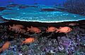
Soldierfish, Baker Island NWR

See also
In Spanish: Monumento nacional marino de las islas remotas del Pacífico para niños
