Wedge (border) facts for kids
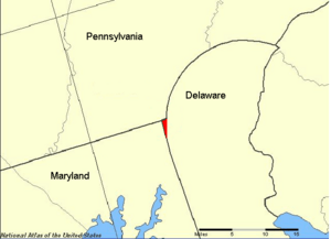
The Wedge, also known as the Delaware Wedge, is a small piece of land. It is about 1 square mile (2.7 square kilometers) in size. This land sits right where the borders of Delaware, Maryland, and Pennsylvania meet. For a long time, people argued about who owned this land. But since 1921, everyone agrees it belongs to Delaware.
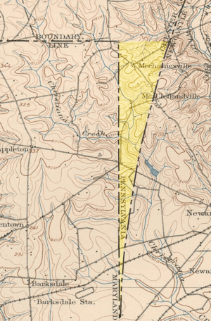
This unusual shape happened because of old-fashioned land surveying. Surveying is how people measure and map land. In the 1700s, their tools were not as good as today's. The Wedge is bordered by parts of the famous Mason–Dixon line. It is also bordered by a circle drawn around New Castle, Delaware. Today, a small community called Mechanicsville, Delaware, is located within the Wedge.
Contents
History of the Wedge
Early Land Claims
In the early days of America, kings in England gave away large pieces of land. In 1632, the King gave land to the Calverts for the Province of Maryland. This land included what is now the Delmarva Peninsula. It stretched north up to the 40th parallel, a line of latitude. Some Dutch settlements, like Zwaanendael, were already in this area. Later, Swedish and Dutch people also settled along the Delaware Bay and Delaware River. The Calverts wanted these settlements gone. But they did not use force because it could cause problems with the King.
In 1664, Prince James, the King's brother, took control of these foreign settlements. The King then decided that the land around New Castle, Delaware and south of it should be a new colony. This new colony would be separate from Maryland.
Later, in 1681, William Penn received his own land grant. This grant was for the Province of Pennsylvania. It gave him land west of the Delaware River and north of the 40th parallel. However, any land within 12 miles (19 km) of New Castle was not included. This shows how little was known about the area. New Castle is actually about 25 miles (40 km) south of the 40th parallel. The Penn family later bought the New Castle lands from Prince James. They called this area the Three Lower Counties. This land later became known as Delaware Colony. It was always a separate area from Pennsylvania.
Drawing the Borders
For about 80 years, the exact borders of these three colonies were argued about. This was a big problem. After settling Philadelphia, the Penn family realized it was south of the 40th parallel. So, they tried to claim land further south. The Calverts had not properly marked their land or settled it.
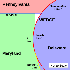
By the 1750s, some progress was made. Surveyors drew the Twelve-Mile Circle around New Castle. This circle became the northern and western border of Delaware. They also drew the Transpeninsular Line as Delaware's southern border. The Calverts and Penns also agreed on other borders. These borders would separate their lands:
- The Transpeninsular Line from the Atlantic Ocean to its middle point.
- A line that touched the western side of the Twelve-Mile Circle. This line would extend to the middle of the Transpeninsular Line.
- A North Line from where the tangent line touched the circle. This line went north to a line about 15 miles (24 km) south of Philadelphia. This was a compromise line at about 39°43′N latitude.
- If any land inside the Twelve-Mile Circle fell west of the North Line, it would stay part of Delaware. This did happen, and that part of the border is called the Arc Line.
Maryland would be south or west of all these borders. Penn's lands (Pennsylvania and Delaware) would be north or east of them. The 39°43′N parallel and the Tangent Line together became the famous Mason–Dixon line.
Finding the Wedge
When these agreements were made, no one knew exactly what the final borders would look like. It was very hard to survey the Twelve-Mile Circle and the Tangent Line. So, two experts, Charles Mason and Jeremiah Dixon, were hired. They drew the complex border known as the Mason–Dixon line.
During their work, they found a small piece of land. It was shaped like a wedge. This land was between the 39°43′N latitude line, the Twelve-Mile Circle, and the North Line. The top of the Wedge is about 0.75 miles (1.2 km) wide. Its side is about 3 miles (4.8 km) long. Maryland clearly had no claim to the Wedge. It was east of the Mason–Dixon Line. Since the Penn family owned both Pennsylvania and Delaware, they did not rush to decide which state it belonged to. This changed when Pennsylvania and Delaware became separate states.
- Pennsylvania claimed the Wedge. They said it was outside the Twelve-Mile Circle. They also said it was past the Maryland side of the Mason–Dixon Line. So, it was not part of Maryland or Delaware.
- Delaware claimed the Wedge. They argued that Pennsylvania was never meant to go below Maryland's northern border. That border was originally at 40°N. The North Line was an extension of the Tangent Line. So, it should separate Maryland and Delaware. Even though the Wedge was outside the Twelve-Mile Circle, it was south of the 39°43′N compromise line. Therefore, Delaware believed it should not be part of Pennsylvania.
Mason and Dixon actually started surveying the Maryland–Pennsylvania border at the Delaware River. The western border of Pennsylvania was supposed to be five degrees of longitude west of this point. Mason and Dixon were to survey the Maryland line all the way to Pennsylvania's western border.
Solving the Mystery
From a geometry point of view, the Wedge made more sense as part of Delaware. Delaware had been taking care of the area. In 1849, Lt. Col. J. D. Graham from the U.S. Army Corps of Topographical Engineers re-surveyed the area. This survey reminded Pennsylvania about the Wedge. They claimed it again. Delaware ignored the claim.
In 1892, another surveyor, W.C. Hodgkins, marked an eastward extension of the Maryland–Pennsylvania border. He created the "Top of The Wedge Line." Finally, in 1921, both states agreed on this border. This agreement officially gave full ownership of the Wedge to Delaware.
Roads in the Wedge
Today, Delaware Route 273 and Delaware Route 896 cross through the Wedge. Route 896 passes very close to the point where the three states meet. It even goes through Maryland for a short bit before entering Pennsylvania. Hopkins Road, a smaller road off Route 896, also passes near the northeast corner of the Wedge. It goes from Delaware into Pennsylvania and then back into Delaware at this spot. The road bordering the Wedge to the east is called Wedgewood Road. For drivers, Route 896 keeps the same number in Delaware, Maryland, and Pennsylvania.
 | Chris Smalls |
 | Fred Hampton |
 | Ralph Abernathy |


