Transpeninsular Line facts for kids

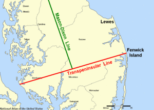
The Transpeninsular Line is a special line drawn on a map that helps separate two states: Delaware and Maryland. It's like a long, invisible fence that runs across a piece of land called the Delmarva Peninsula. This line starts near the Atlantic Ocean and goes all the way to the Chesapeake Bay. Part of this line also helps make up the famous Mason–Dixon line.
Contents
What is the Transpeninsular Line?
This line was first measured in 1751. It was meant to be the southern border of Delaware. The starting point was a place that some early settlers called Cape Hinlopen. Today, this spot is known as Fenwick Island.
A Big Mix-Up with Capes
There was a lot of confusion because there's another cape called Cape Henlopen much further north, near Lewes, Delaware. The names sound very similar! The word henlopen can mean "entering in" or "approaching."
This mix-up caused a big argument between two important families: the Penns (who were in charge of Delaware) and the Calverts (who were in charge of Maryland). The Calverts thought the border should start at the Cape Henlopen near Lewes. If they had won, Delaware would be much smaller, losing more than a third of its land!
How the Problem Was Solved
In 1732, Charles Calvert had a map made. This map showed Cape Henlopen at Fenwick Island, which was the spot the Penns wanted. Calvert didn't realize his map was based on an older map that had the capes mixed up. When the English court decided the border, they used Calvert's own map against him! He tried to get the court to ignore his map later, but it was too late.
So, in 1751, the line was officially measured from the spot the court chose (Penn's Cape Henlopen) all the way to the Chesapeake Bay. Later, in 1763, two famous surveyors named Charles Mason and Jeremiah Dixon used this line when they were mapping the north-south border between Maryland and Delaware, which became part of the well-known Mason–Dixon line.
Towns Divided by the Line
The Transpeninsular Line goes right through some towns on the Delmarva Peninsula, splitting them between the two states. The most famous example is Delmar, Delaware, and Delmar, Maryland. Their names even come from combining "Delaware" and "Maryland"!
Finding the Markers
You can find special markers that show where the Transpeninsular Line is.
- One marker is near the Fenwick Island Lighthouse. This is at the northern edge of Ocean City, Maryland, on 146th Street.
- Another marker is about halfway along the line. You can find it on the north side of Route 54, between Delmar and Mardela Springs, Maryland. This marker is also the very southern end of the Mason–Dixon Line.
 | Calvin Brent |
 | Walter T. Bailey |
 | Martha Cassell Thompson |
 | Alberta Jeannette Cassell |

