
Mountain states facts for kids


The Mountain States are a special part of the Western United States. They are also called the Mountain West or the Interior West. This area is one of nine big geographic sections of the United States. The United States Census Bureau officially recognizes these sections.
This region usually includes eight states: Arizona, Colorado, Idaho, Montana, Nevada, New Mexico, Utah, and Wyoming. The name "Mountain States" comes from the fact that these states contain parts of the famous Rocky Mountains. These mountains stretch from north to south through Montana, Idaho, Wyoming, Colorado, Utah, and New Mexico. Arizona and Nevada also have many smaller mountain ranges. Sometimes, a small part of West Texas called Trans-Pecos is also included. All eight states together cover a huge area of about 855,767 square miles (2,216,426 square kilometers).
There are a few smaller areas within the Mountain States:
- The Southwest includes Arizona, New Mexico, southern Nevada, and deep west Texas.
- The Intermountain region covers Utah, Nevada, Idaho, and parts of other states.
- The Front Range region includes northern New Mexico, Colorado, and southeast Wyoming.
Contents
Exploring the Mountain West: A Diverse Region
The Mountain West is one of the biggest and most varied regions in the United States. Its borders often stretch from the High Plains in the east to the Sierra Nevada and Cascade Range mountains in the west.
Sometimes, the Mountain West is split into two parts. The southern part, which includes Arizona and New Mexico, is often called the Southwest. The northern part, with Idaho and Montana, is sometimes grouped with the Northwest states or called the "Northern Rockies."
Landscapes of the Mountain States: From Peaks to Deserts


The Mountain States are part of the larger "West" region of the U.S. This region also includes the Pacific States like Alaska, California, Hawaii, Oregon, and Washington. The Mountain West has more different types of land than any other U.S. region. You can find some of the highest mountain peaks in the country here. You'll also see huge deserts and flat, rolling plains in the eastern parts.
All the major deserts in North America are found in the Mountain West states.
- The Great Basin Desert covers most of Nevada, western Utah, and southern Idaho.
- The Mojave Desert is mostly in southern Nevada, even though parts are in California.
- The Sonoran Desert covers much of Arizona.
- The Chihuahuan Desert is in most of southwestern and southern New Mexico. This includes famous spots like White Sands.
Colorado, New Mexico, Utah, and Arizona also have other smaller desert areas. These are part of the Colorado Plateau. For example, the Painted Desert is in northern Arizona. The San Rafael Desert is in eastern Utah. Colorado has large desert lands in its northwestern, western, and southern parts. These areas include places like Royal Gorge and Colorado National Monument. The San Luis Valley in Colorado is the world's largest high valley desert.
In the far eastern parts of the Mountain West, you'll find the High Plains. These are part of the larger Great Plains. The High Plains are mostly flat, rolling lands. They have some scattered buttes (flat-topped hills), canyons, and forests. This area gets very little rain and is at a high elevation, usually between 3,000 to 6,000 feet (914 to 1,829 meters). Many people think of the High Plains as the gateway to the Mountain West.
The Mountain West is home to some of America's tallest mountains. Some well-known peaks include Mount Elbert, Pikes Peak, Longs Peak, Kings Peak, Cloud Peak, Wheeler Peak, Granite Peak, Borah Peak, and Humphreys Peak.
Weather in the Mountain States: A Mix of Extremes


The climate in the Mountain West is very diverse. Most of the region has a dry or semi-dry climate. However, the mountains have an alpine climate, meaning they are cold and snowy. Some tall mountains get a lot of snow and rain. Other parts of the region get very little rain and almost no snow. The High Plains in the east get moderate snow but little rain.
Nevada and Arizona are mostly covered by deserts and scattered mountains. Southern Nevada gets little to no snow. But northern Nevada can get a lot of snow, even in its desert areas. Arizona generally gets little rain or snow. However, high places near mountains get huge amounts of rain and snow. Northern Arizona has a "High Desert" climate. This means summers are very hot and dry, but winters can be very cold with snow.
Utah also has large desert areas with mountains. The deserts in Utah get a good amount of snowfall. The mountains get very heavy snow. Colorado and New Mexico have similar climates. Both states get significant snow outside the mountains, and their mountains get extremely large amounts of snow. However, southern New Mexico gets very little snow, much like southern Nevada and Arizona. The desert lands in northeastern Arizona, eastern Utah, northern New Mexico, and western Colorado are often called "High Desert" lands.
The northern Mountain West is usually cooler than the southwestern areas. Idaho and Montana both get a lot of snow outside the mountains and huge amounts of snow in the mountains. The High Desert also exists in the northern Mountain West. Parts of southeastern Oregon and southern Idaho have the Great Basin Desert, which is a high desert.
The eight Mountain States have the highest average elevations of all 50 U.S. states.
Time Zones: What Time Is It?

Most of the Mountain States use Mountain Time. However, Nevada (except for West Wendover) and the Idaho Panhandle use Pacific Time.
Daylight saving time is not used in most of Arizona. This means that from March to November, most of Arizona is one hour behind the rest of the Mountain Time Zone. The only exception is the Navajo Nation in the northeast corner of Arizona, which does observe daylight saving time because it crosses state lines.
States of the Mountain West
| Rank | State | Highest point | Highest elevation | Lowest point | Lowest elevation | Mean elevation | Elevation span |
|---|---|---|---|---|---|---|---|
| 1 | Colorado | Mount Elbert | 14,440 ft 4401 m |
Arikaree River at Kansas border | 3,317 ft 1011 m |
6,800 ft 2073 m |
11,123 ft 3390 m |
| 2 | Wyoming | Gannett Peak | 13,809 ft 4209 m |
Belle Fourche River at South Dakota border | 3,100 ft 945 m |
6,693 ft 2040 m |
10,709 ft 3264 m |
| 3 | Utah | Kings Peak | 13,518 ft 4120 m |
Beaver Dam Wash at Arizona border | 2,180 ft 664 m |
6,100 ft 1859 m |
11,338 ft 3456 m. |
| 4 | New Mexico | Wheeler Peak | 13,167 ft 4013 m |
Red Bluff on Texas border | 2,842 ft 866 m |
5,700 ft 1737 m |
10,325 ft 3147 m |
| 5 | Nevada | Boundary Peak | 13,147 ft 4007 m |
Colorado River at California border | 479 ft 146 m |
5,500 ft 1676 m |
12,668 ft 3861 m |
| 6 | Idaho | Borah Peak | 12,668 ft 3861 m |
Snake River at Washington border | 710 ft 216 m |
5,000 ft 1524 m |
11,958 ft 3645 m |
| 7 | Arizona | Humphreys Peak | 12,637 ft 3852 m |
Colorado River at Sonora border | 70 ft 21 m |
4,100 ft 1250 m |
12,567 ft 3830 m |
| 8 | Montana | Granite Peak | 12,807 ft 3904 m |
Kootenai River at Idaho border. | 1,800 ft 549 m |
3,400 ft 1036 m |
11,007 ft 3355 m |
| Mountain States | Mount Elbert | 14,440 ft 4401 m |
Colorado River at Sonora border. | 70 ft 21 m |
5,400 ft 1646 m. |
14,370 ft 4380 m. |
|
Major Cities: Bustling Hubs of the Mountain West


The Phoenix metropolitan area in Arizona is the largest city area in the Mountain States. After Phoenix, the biggest cities are Denver, Las Vegas, and Salt Lake City. Phoenix is also the single most populated city.
Here are the 30 most populated cities in the Mountain States:
| Rank | City | State | 2014 pop est | 2010 pop | Change |
|---|---|---|---|---|---|
| 1 | Phoenix | Arizona | 1,537,058 | 1,445,632 | +6.32% |
| 2 | Denver | Colorado | 663,862 | 600,158 | +10.61% |
| 3 | Las Vegas | Nevada | 613,599 | 583,756 | +5.11% |
| 4 | Albuquerque | New Mexico | 557,169 | 545,852 | +2.07% |
| 5 | Tucson | Arizona | 527,972 | 520,116 | +1.51% |
| 6 | Mesa | Arizona | 464,704 | 439,041 | +5.85% |
| 7 | Colorado Springs | Colorado | 445,830 | 416,427 | +7.06% |
| 8 | Aurora | Colorado | 353,108 | 325,078 | +8.62% |
| 9 | Henderson | Nevada | 277,440 | 257,729 | +7.65% |
| 10 | Chandler | Arizona | 254,276 | 236,123 | +7.69% |
| 11 | Gilbert | Arizona | 239,277 | 208,453 | +14.79% |
| 12 | Glendale | Arizona | 237,517 | 226,721 | +4.76% |
| 13 | Reno | Nevada | 236,995 | 225,221 | +5.23% |
| 14 | North Las Vegas | Nevada | 230,788 | 216,961 | +6.37% |
| 15 | Scottsdale | Arizona | 230,512 | 217,385 | +6.04% |
| 16 | Boise | Idaho | 216,282 | 205,671 | +5.16% |
| 17 | Salt Lake City | Utah | 190,884 | 186,440 | +2.38% |
| 18 | Tempe | Arizona | 172,816 | 161,719 | +6.86% |
| 19 | Peoria | Arizona | 166,934 | 154,065 | +8.35% |
| 20 | Fort Collins | Colorado | 156,480 | 143,986 | +8.68% |
| 21 | Lakewood | Colorado | 149,643 | 142,980 | +4.66% |
| 22 | West Valley City | Utah | 134,495 | 129,480 | +3.87% |
| 23 | Thornton | Colorado | 130,307 | 118,772 | +9.71% |
| 24 | Surprise | Arizona | 126,275 | 117,517 | +7.45% |
| 25 | Provo | Utah | 114,801 | 112,488 | +2.06% |
| 26 | Arvada | Colorado | 113,574 | 106,433 | +6.71% |
| 27 | Westminster | Colorado | 112,090 | 106,114 | +5.63% |
| 28 | West Jordan | Utah | 110,920 | 103,712 | +6.95% |
| 29 | Billings | Montana | 108,869 | 104,170 | +4.51% |
| 30 | Pueblo | Colorado | 108,423 | 106,595 | +1.71% |

Images for kids
-
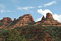
Bell Rock near Sedona, Arizona.
-
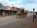
A historic street in Tombstone, Arizona.
-
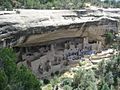
The Cliff Palace in Mesa Verde National Park in Colorado.
-
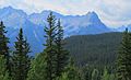
The rugged San Juan Mountains in Colorado.
-
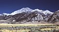
Borah Peak is the highest point in Idaho.
-
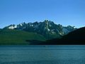
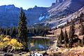
Redfish Lake in Idaho.
-
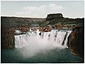
Shoshone Falls on the Snake River in Idaho, photographed in 1898.
-
The Absaroka Range of Montana.
-
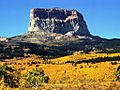
Autumn colors around Chief Mountain in Glacier National Park in Montana.
-
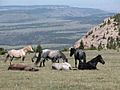
Wild horses in the Pryor Mountain Wild Horse Range in Montana.
-
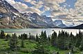
Saint Mary Lake in Glacier National Park in Montana.
-
Stella Lake in Great Basin National Park in Nevada.
-
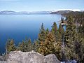
The Nevada side of Lake Tahoe.
-
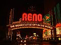
Downtown Reno, Nevada.
-
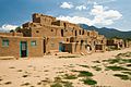
The historic Taos Pueblo of New Mexico.
-
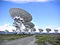
The Very Large Array near Socorro, New Mexico.
-
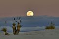
Moonrise at White Sands National Park in New Mexico.
-
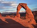
Sunset at Delicate Arch in Arches National Park in Utah.
-
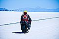
The Bonneville Salt Flats in Utah.
-
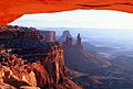
Mesa Arch in Canyonlands National Park in Utah.
-
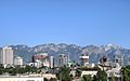
The skyline of Salt Lake City.
-
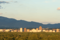
Evening in Tucson.
-
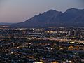
The Albuquerque skyline with the Sandia Mountains in the distance.
-
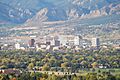
The skyline of Colorado Springs with the Front Range in the background.
-

The Idaho State Capitol in Boise.
.jpg)


.jpg)


See also
 In Spanish: Estados montañosos para niños
