
Sedona, Arizona facts for kids
Quick facts for kids
City of Sedona
|
|||
|---|---|---|---|

|
|||
|
|||

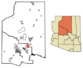
Location of Sedona in Coconino County and Yavapai County, Arizona
|
|||

Sedona, Arizona
Location in Arizona

Sedona, Arizona
Location in the United States
|
|||
| Country | United States | ||
| State | |||
| Counties | Yavapai, Coconino | ||
| Founded | 1902 | ||
| Incorporated | 1988 | ||
| Government | |||
| • Type | Council–Manager | ||
| Area | |||
| • Total | 18.30 sq mi (47.41 km2) | ||
| • Land | 18.26 sq mi (47.30 km2) | ||
| • Water | 0.04 sq mi (0.11 km2) | ||
| Elevation | 4,360 ft (1,330 m) | ||
| Population
(2020)
|
|||
| • Total | 9,684 | ||
| • Density | 530.28/sq mi (204.75/km2) | ||
| Time zone | UTC−07:00 (MST) | ||
| ZIP Code |
86336
|
||
| Area code(s) | 928 | ||
| FIPS code | 04-65350 | ||
| GNIS feature ID | 2411858 | ||

.gif)

Sedona (/sɪˈdoʊnə/ si-DOH-nə) is a city in Arizona, USA. It is special because it sits on the border of two counties: Coconino and Yavapai. In 2010, about 10,031 people lived there. Sedona is surrounded by the beautiful Coconino National Forest.
The most famous thing about Sedona is its amazing red sandstone rocks. These rocks look like they glow bright orange and red when the sun rises or sets. They make a fantastic background for many activities. People come here for spiritual reasons or to enjoy hundreds of hiking and mountain biking trails.
Sedona got its name from Sedona Schnebly. Her husband, Theodore Carlton Schnebly, was the city's first postmaster. Sedona Schnebly was known for being very welcoming and hardworking. Her mother, Amanda Miller, said she just made up the name because it "sounded pretty."
Contents
History of Sedona
Early Settlers in Sedona
The first European-American settler, John J. Thompson, arrived in Oak Creek Canyon in 1876. This area was already famous for its peach and apple farms. The early people who settled here were mostly farmers and ranchers.
In 1902, when Sedona got its own post office, only 55 people lived there. By the mid-1950s, the first phone book listed 155 names. Some parts of Sedona did not even have electricity until the 1960s.
At first, Sedona did not have a local government, and it was split between two counties. The area started to grow much faster after someone found a good water source. This meant people did not have to carry water anymore, and they could build more homes and roads.
Sedona began to become a popular place for tourists, vacation homes, and retired people in the 1950s. Most of the buildings you see today were built in the 1980s and 1990s. By 2007, there was not much empty land left to build on.
Chapel of the Holy Cross
In 1956, a special building called the Chapel of the Holy Cross was finished. This chapel stands about 70 feet (21 meters) tall. It rises from a 1,000-foot (300-meter) red rock cliff. The most striking part of the chapel is its large cross. Inside, there is a window and a cross, with benches for people to sit.
Sedona in Movies
Sedona's red rocks have been a popular spot for Hollywood movies. More than sixty films were made here from the early days of movies until the 1970s. Some famous movies filmed in Sedona include Angel and the Badman, Johnny Guitar, and Broken Arrow.
However, in these movies, the Sedona landscape was often shown as places like Texas, California, or Nevada. The city itself lent its name to a 2011 movie called Sedona, which takes place in the community.
Wildfires Near Sedona

In 2006, a wildfire called the Brins Fire started near Sedona. It was believed to have been started by campers. The fire burned about 4,317 acres (17.47 square kilometers) of land. It affected Brins Mesa, Wilson Mountain, and Oak Creek Canyon. Firefighters got it completely under control after ten days.
Another wildfire, the Slide Fire, began in 2014. This fire started at Slide Rock State Park, north of Sedona. It spread across 21,227 acres (85.90 square kilometers) in Oak Creek Canyon. This fire caused people to leave their homes for a while.
Geography and Nature

Sedona is located in northern Arizona. It has mild winters and warm summers. The city covers about 49.7 square kilometers (19.2 square miles) of land. Only a very small part of it is water.
Plants and Trees in Sedona
Sedona has many types of plants. In the chaparral areas, you can find shrubs and small trees like scrub oaks and sumac. Higher up in the Great Basin woodland, there are many small to medium-sized trees. These include different kinds of pines and junipers. In Oak Creek Canyon, you can also find other types of pines and junipers.

Sedona's Famous Red Rocks
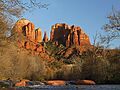
The amazing red rocks of Sedona are made from a special layer of rock. This rock is called the Schnebly Hill Formation. It is a thick layer of red to orange-colored sandstone. You can only find this type of sandstone in the Sedona area. It formed a very long time ago, during the Permian Period.
Some of the well-known rock formations in Sedona include:
- Seven Sacred Pools
- Bell Rock
- Capitol Butte
- Cathedral Rock
- Courthouse Butte
- Devil's Kitchen Sinkhole
- House Mountain
- Two Nuns
- Wilson Mountain (which is the tallest)
Sedona's Climate
Sedona has a cold semi-arid climate. This means it is generally dry, but not a desert.
- In January, the average high temperature is about 58.3°F (14.6°C). The low is around 34.0°F (1.1°C).
- In July, the average high temperature is about 96.9°F (36.1°C). The low is around 67.6°F (19.8°C).
- Sedona gets a little over 17 inches (430 mm) of rain each year.
| Climate data for Sedona, Arizona (1991–2020 normals, extremes 1943–2010) | |||||||||||||
|---|---|---|---|---|---|---|---|---|---|---|---|---|---|
| Month | Jan | Feb | Mar | Apr | May | Jun | Jul | Aug | Sep | Oct | Nov | Dec | Year |
| Record high °F (°C) | 81 (27) |
85 (29) |
88 (31) |
93 (34) |
102 (39) |
111 (44) |
115 (46) |
108 (42) |
106 (41) |
100 (38) |
88 (31) |
80 (27) |
110 (43) |
| Mean maximum °F (°C) | 70.3 (21.3) |
74.3 (23.5) |
78.8 (26.0) |
86.9 (30.5) |
94.0 (34.4) |
103.4 (39.7) |
104.4 (40.2) |
102.8 (39.3) |
98.0 (36.7) |
89.9 (32.2) |
79.6 (26.4) |
73.0 (22.8) |
105.9 (41.1) |
| Mean daily maximum °F (°C) | 58.3 (14.6) |
61.3 (16.3) |
67.5 (19.7) |
74.7 (23.7) |
83.7 (28.7) |
94.1 (34.5) |
96.9 (36.1) |
94.2 (34.6) |
88.8 (31.6) |
78.7 (25.9) |
66.9 (19.4) |
57.8 (14.3) |
76.9 (25.0) |
| Daily mean °F (°C) | 46.2 (7.9) |
48.8 (9.3) |
53.7 (12.1) |
59.4 (15.2) |
68.4 (20.2) |
77.7 (25.4) |
82.3 (27.9) |
80.6 (27.0) |
75.1 (23.9) |
64.8 (18.2) |
53.9 (12.2) |
45.3 (7.4) |
63.0 (17.2) |
| Mean daily minimum °F (°C) | 34.0 (1.1) |
36.2 (2.3) |
39.8 (4.3) |
44.0 (6.7) |
53.2 (11.8) |
61.2 (16.2) |
67.6 (19.8) |
66.9 (19.4) |
61.4 (16.3) |
51.0 (10.6) |
40.9 (4.9) |
32.8 (0.4) |
49.1 (9.5) |
| Mean minimum °F (°C) | 22.0 (−5.6) |
23.8 (−4.6) |
27.5 (−2.5) |
31.9 (−0.1) |
38.6 (3.7) |
47.3 (8.5) |
58.4 (14.7) |
57.8 (14.3) |
49.7 (9.8) |
38.2 (3.4) |
28.3 (−2.1) |
23.0 (−5.0) |
18.4 (−7.6) |
| Record low °F (°C) | 4 (−16) |
8 (−13) |
15 (−9) |
23 (−5) |
29 (−2) |
36 (2) |
48 (9) |
48 (9) |
38 (3) |
23 (−5) |
12 (−11) |
8 (−13) |
4 (−16) |
| Average precipitation inches (mm) | 2.04 (52) |
2.17 (55) |
1.94 (49) |
0.77 (20) |
0.68 (17) |
0.16 (4.1) |
1.62 (41) |
2.04 (52) |
1.72 (44) |
1.38 (35) |
1.12 (28) |
1.48 (38) |
17.12 (435.1) |
| Average snowfall inches (cm) | 0.7 (1.8) |
0.3 (0.76) |
0.2 (0.51) |
0.1 (0.25) |
0.0 (0.0) |
0.0 (0.0) |
0.0 (0.0) |
0.0 (0.0) |
0.0 (0.0) |
0.0 (0.0) |
0.2 (0.51) |
0.4 (1.0) |
1.9 (4.83) |
| Average precipitation days (≥ 0.01 in) | 5.5 | 5.6 | 5.8 | 3.3 | 2.7 | 1.4 | 6.4 | 9.0 | 4.7 | 3.3 | 3.4 | 3.8 | 54.9 |
| Source 1: NOAA | |||||||||||||
| Source 2: WRCC(snow-records-mean maximum/minimum) | |||||||||||||

People and Community
| Historical population | |||
|---|---|---|---|
| Census | Pop. | %± | |
| 1970 | 2,022 | — | |
| 1980 | 5,368 | 165.5% | |
| 1990 | 7,720 | 43.8% | |
| 2000 | 10,192 | 32.0% | |
| 2010 | 10,031 | −1.6% | |
| 2020 | 9,684 | −3.5% | |
| U.S. Decennial Census | |||

In 2000, Sedona had 10,192 people living in 4,928 homes. About 2,863 of these were families. The city had about 548 people per square mile (211 people per square kilometer).
Most people in Sedona were White (92.2%). About 8.9% of the population were Hispanic or Latino. In 2000, about 70.9% of Sedona's population lived in the Yavapai County part of the city. The other 29.1% lived in the Coconino County part.
About 13.7% of the people were under 18 years old. Around 25.6% were 65 years or older. The average age in Sedona was 50 years. The average income for a household was $44,042. For families, it was $52,659.
Arts and Fun Activities

Sedona hosts many fun events throughout the year:
- St. Patrick's Day parade
- Celebration of Spring
- Sedona Food Truck Festival
- Red Dirt Concerts
- Pumpkin Splash
- WagFest and Fair (for pets and their owners)
- Sedona Marathon
- Sedona Miracle Annual Charity Fundraiser
- Sedona Hummingbird Festival
- The Sedona Solstice Festivals (in summer and winter)
Sedona also has several arts groups:
- Chamber Music Sedona, which offers classical music concerts.
- Sedona Arts Center, started in 1958, is the oldest arts center in northern Arizona.
- Sedona International Film Festival, which began in 1995.
- Greg Lawson Galleries, featuring local art.
Some people believe Sedona has special "spiritual vortices" at places like Bell Rock, Airport Mesa, Cathedral Rock, and Boynton Canyon. The Sedona Wetlands Preserve is a great place for watching birds.
Education in Sedona
Sedona is part of the Sedona-Oak Creek Unified School District.
- West Sedona School teaches students from kindergarten to 6th grade.
- Sedona Red Rock High School (SRRHS) was built in 1994. Its mascot is the Scorpion. The high school also includes grades 7-8 in its Junior High section.
- Red Rock Early Learning Center is a preschool for children aged 3–5.
Before 1991, Sedona students went to schools in other districts. The Sedona school district opened in 1991.
Verde Valley School is a special boarding high school. It offers the International Baccalaureate program and has many students from around the world. It is known for its traditions and performances. The school's mascot is the coyote. Famous composer James Horner (who wrote music for Titanic and Avatar) studied here.
Sedona Charter School (SCS) is a Montessori-based school for grades K–8. It is located behind the Sedona Public Library.
Yavapai College has a campus in Sedona. It offers programs in arts and technology. This includes the Sedona Film School, where students can learn about filmmaking.
City Services
Getting Around Sedona
Sedona Airport is a small airport within the city. It is used for general aviation, not large commercial flights. The closest major airports are:
- Flagstaff Pulliam Airport (about 26 miles away)
- Prescott Regional Airport (about 68 miles away)
- Phoenix Sky Harbor International Airport (about 119 miles away)
Healthcare in Sedona
Verde Valley Medical Center – Sedona Campus provides healthcare services. It has 24/7 emergency services, cancer care, and other medical help. It is part of the Northern Arizona Healthcare system.
Cemeteries in Sedona
Sedona has several cemeteries:
- The Schuerman–Red Rock Cemetery is the oldest, dating back to 1893.
- Cooks Cedar Gate Cemetery had its first burial in 1918.
- The Sedona Community Cemetery, also called Sedona Memorial Park, is on Pine Drive.
Notable People from Sedona
Many interesting people have lived in Sedona, including:
- Samaire Armstrong – an actress
- Michelle Branch – a singer and songwriter
- James Horner – a famous film composer
- Greg Lawson – a photographer and author
- Tom O'Halleran – a U.S. representative
Images for kids
-
Cathedral Rock
-

Flag of Sedona
-
Seal of Sedona
-
Location of Sedona
-
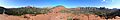
Panoramic view of Sedona from the "vortex" point near the Sedona airport. The famous Bell Rock, located on the south side of the vortex point, is on the right side of the photo. Major parts of the town are in the middle of the photo. Capitol Butte is to the left.
See also
 In Spanish: Sedona para niños
