Yavapai County, Arizona facts for kids
Quick facts for kids
Yavapai County
|
|||
|---|---|---|---|
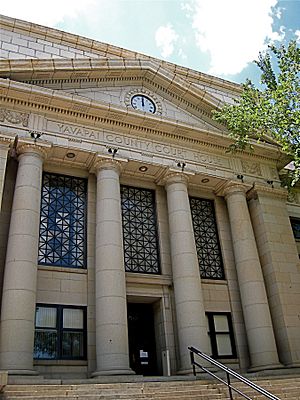
Yavapai County Courthouse in Prescott
|
|||
|
|||
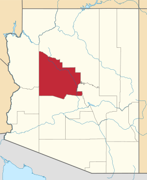
Location within the U.S. state of Arizona
|
|||
 Arizona's location within the U.S. |
|||
| Country | |||
| State | |||
| Founded | November 9, 1864 | ||
| Named for | Yavapai people | ||
| Seat | Prescott | ||
| Largest city | Prescott Valley | ||
| Area | |||
| • Total | 8,128 sq mi (21,050 km2) | ||
| • Land | 8,123 sq mi (21,040 km2) | ||
| • Water | 4.4 sq mi (11 km2) 0.05% | ||
| Population
(2020)
|
|||
| • Total | 236,209 | ||
| • Estimate
(2023)
|
249,081 |
||
| • Density | 29.0611/sq mi (11.2206/km2) | ||
| Time zone | UTC−7 (Mountain) | ||
| Congressional district | 2nd | ||
Yavapai County is a county located near the center of Arizona, a state in the United States. In 2020, about 236,209 people lived here. This makes it the fourth-most populated county in Arizona. The main city, or county seat, where the county government is located, is Prescott.
Yavapai County includes the area around Prescott Valley and Prescott. It also covers parts of Peoria and Wickenburg. These areas are part of a larger region called a Metropolitan Statistical Area.
Contents
Discovering Yavapai County's Past
Yavapai County was one of the first four counties created in Arizona. This happened when the first Arizona Territorial Legislature met in 1864. At first, the county was much larger. Its borders were set to the east of a certain longitude and north of the Gila River.
Over time, other counties were formed from parts of Yavapai County. These new counties included Apache, Coconino, Maricopa, and Navajo. Yavapai County's current borders were decided in 1891.
The county gets its name from the Yavapai people. They were the main group of people living in this area when the United States took control. The Yavapai County Sheriff's Office has been providing law enforcement services since 1864.
Exploring Yavapai County's Geography
Yavapai County covers a total area of about 8,128 square miles. Most of this area, about 8,123 square miles, is land. Only a small part, about 4.4 square miles, is water. This county is very large, almost as big as the state of New Jersey. It is even larger than three U.S. states combined: Rhode Island, Delaware, and Connecticut.
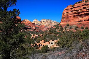
The land in Yavapai County changes a lot from south to north. In the south, you'll find the lower Sonoran Desert. As you go north, the land rises to the Coconino Plateau. To the east, there is the Mogollon Rim.
The highest point in Yavapai County is Mount Union. It stands tall at about 7,979 feet (2,432 meters) above sea level. The lowest point is where the Agua Fria River used to flow, which is now under Lake Pleasant.
Neighboring Counties of Yavapai
Yavapai County shares its borders with several other counties:
- Mohave County to the west
- La Paz County to the southwest
- Maricopa County to the south
- Gila County to the south and southeast
- Coconino County to the north and northeast
Main Roads in Yavapai County
Many important highways pass through Yavapai County, connecting it to other parts of Arizona and beyond.
 Interstate 17
 Interstate 40
 U.S. Route 93
 State Route 69
 State Route 71
 State Route 89
 State Route 169
 State Route 179
 State Route 260
 State Route 279
Protected Natural Areas
Yavapai County is home to many beautiful natural areas that are protected. These include:
- Agua Fria National Monument
- Coconino National Forest (part)
- Kaibab National Forest (part)
- Montezuma Castle National Monument
- Prescott National Forest (part)
- Tonto National Forest (part)
- Tuzigoot National Monument
There are also nineteen special wilderness areas in Yavapai County. These areas are kept wild and untouched. Some of them are part of the National Forests, while others are managed by the Bureau of Land Management. Some of these wilderness areas also extend into neighboring counties.
- Apache Creek Wilderness (Prescott NF)
- Castle Creek Wilderness (Prescott NF)
- Cedar Bench Wilderness (Prescott NF)
- Fossil Springs Wilderness (Coconino NF)
- Granite Mountain Wilderness (Arizona) (Prescott NF)
- Hassayampa River Canyon Wilderness (BLM)
- Hells Canyon Wilderness (Arizona) (BLM)
- Juniper Mesa Wilderness (Prescott NF)
- Mazatzal Wilderness (Tonto NF / Coconino NF)
- Munds Mountain Wilderness (Coconino NF)
- Pine Mountain Wilderness (Tonto NF/Prescott NF)
- Red Rock-Secret Mountain Wilderness (Coconino NF)
- Sycamore Canyon Wilderness (Prescott NF/Coconino NF / Kaibab NF)
- Tres Alamos Wilderness (BLM)
- Upper Burro Creek Wilderness (BLM)
- West Clear Creek Wilderness (Coconino NF)
- Wet Beaver Wilderness (Coconino NF)
- Woodchute Wilderness (Prescott NF)
Land Ownership and Management
About 25% of the land in Yavapai County is privately owned. This means individuals or companies own it. The other 75% is public land.
About half of the county's land is owned by the federal government of the United States. This includes:
- National Forest lands, managed by the US Forest Service: 38% of the county's area.
- Federal lands managed by the U.S. Bureau of Land Management: 11.6% of the county's area.
- Small areas managed by the U.S. Bureau of Indian Affairs and the National Park Service. These include lands for the Yavapai-Prescott Tribe (1,413 acres) and the Yavapai-Apache Nation (685 acres).
About 25% of Yavapai County is owned by the State of Arizona. These are called state trust lands and are managed by the Arizona State Land Department.
Plants and Animals of Yavapai County
Yavapai County is home to many different kinds of plants and animals. For example, you can find various types of plants like Ephedra and Coreopsis. The county also has several groups of California Fan Palm trees, which are called Washingtonia filifera. These palms are considered near-threatened.
Fun Places to Visit in Yavapai County
Yavapai County has some unique attractions. One of them is Arcosanti. This is a special experimental town that started being built in 1970. It was designed by Paolo Soleri to be a new kind of city that blends with nature. Arcosanti is located just north of Cordes Junction, Arizona.
Another popular spot is the Out of Africa Wildlife Park. This is a private zoo that moved to the Camp Verde area in 2005. It's a great place to see different animals.
About 10 miles northwest of the town of Bagdad, you'll find the Upper Burro Creek Wilderness Area. This protected area covers about 27,440 acres. It is home to at least 150 different types of birds. It also has one of the few natural, flowing streams in the Arizona desert that hasn't been dammed.
People and Population in Yavapai County
| Historical population | |||
|---|---|---|---|
| Census | Pop. | %± | |
| 1870 | 2,142 | — | |
| 1880 | 5,013 | 134.0% | |
| 1890 | 8,685 | 73.2% | |
| 1900 | 13,799 | 58.9% | |
| 1910 | 15,996 | 15.9% | |
| 1920 | 24,016 | 50.1% | |
| 1930 | 28,470 | 18.5% | |
| 1940 | 26,511 | −6.9% | |
| 1950 | 24,991 | −5.7% | |
| 1960 | 28,912 | 15.7% | |
| 1970 | 36,733 | 27.1% | |
| 1980 | 68,145 | 85.5% | |
| 1990 | 107,714 | 58.1% | |
| 2000 | 167,517 | 55.5% | |
| 2010 | 211,033 | 26.0% | |
| 2020 | 236,209 | 11.9% | |
| 2023 (est.) | 249,081 | 18.0% | |
| U.S. Decennial Census 1790–1960 1900–1990 1990–2000 2010–2020 |
|||
The population of Yavapai County has grown a lot over the years. In 2010, there were 211,033 people living in the county. There were 90,903 households and 57,597 families. The county had about 26 people per square mile.
In 2010, most people in the county were white (89.3%). Other groups included American Indian (1.7%), Asian (0.8%), and Black or African American (0.6%). About 13.6% of the population was of Hispanic or Latino origin.
The average age of people in Yavapai County in 2010 was 49.2 years old. The median income for a household was $43,290. For families, it was $53,499. About 13.7% of the people in the county lived below the poverty line. This included 20.1% of those under 18 years old.
Cities and Towns in Yavapai County
Yavapai County has many different communities, from large cities to small towns and even some historic ghost towns.
Cities in Yavapai County
- Cottonwood
- Peoria (mostly in Maricopa County)
- Prescott (the county seat)
- Sedona (partly in Coconino County)
Towns in Yavapai County
- Camp Verde
- Chino Valley
- Clarkdale
- Dewey-Humboldt
- Jerome
- Prescott Valley
- Wickenburg (partly in Maricopa County)
Census-Designated Places
These are areas that are like towns but are not officially incorporated as cities or towns.
- Ash Fork
- Bagdad
- Black Canyon City
- Congress
- Cordes Lakes
- Cornville
- Lake Montezuma
- Mayer
- Paulden
- Peeples Valley
- Seligman
- Spring Valley
- Verde Village
- Village of Oak Creek
- Wilhoit
- Williamson
- Yarnell
Native American Communities
Unincorporated Communities
These are small communities that are not officially part of a city or town.
- Arcosanti
- Bumble Bee
- Cherry
- Cleator
- Clemenceau
- Cordes
- Crown King
- Drake
- Iron Springs
- Kirkland
- Ponderosa Park
- Skull Valley
- Tip Top
Historic Ghost Towns
These are towns that were once active but are now mostly deserted.
- Alexandra
- American Ranch
- Apron Crossing
- Big Bug
- Bradshaw City
- Bumble Bee
- Chaparral
- Catoctin
- Cherry
- Cleator
- Clemenceau
- Congress
- Cordes
- Curtis
- Gillett
- Jerome Junction
- Octave
- Simmons
- Stanton
- Stoddard
- Tip Top
- Weaver
- Columbia
Notable Geographic Features
Sunset Point is a tall cliff next to Interstate 17. It is about 3,091 feet high. There's a rest area at the top of the cliff. It gives travelers a beautiful view of the area.
Education in Yavapai County
Yavapai County has many school districts that serve its communities.
Unified School Districts
These districts include both elementary and high schools.
- Ash Fork Joint Unified District
- Bagdad Unified School District
- Camp Verde Unified District
- Chino Valley Unified District
- Humboldt Unified District
- Mayer Unified District
- Prescott Unified District
- Seligman Unified District
- Sedona-Oak Creek Joint Unified District
- Wickenburg Unified District
Secondary School Districts
- Mingus Union High School District
Elementary School Districts
- Beaver Creek Elementary District
- Canon Elementary District
- Clarkdale-Jerome Elementary District
- Congress Elementary District
- Cottonwood-Oak Creek Elementary District
- Crown King Elementary District
- Hillside Elementary District
- Kirkland Elementary District
- Pine Strawberry Elementary District
- Skull Valley Elementary District
- Williamson Valley Elementary School District
- Yarnell Elementary District
See also
 In Spanish: Condado de Yavapai para niños
 | Selma Burke |
 | Pauline Powell Burns |
 | Frederick J. Brown |
 | Robert Blackburn |


