
Clarkdale, Arizona facts for kids
Quick facts for kids
Clarkdale
|
||
|---|---|---|
| Clarkdale, Arizona | ||
.jpg)
Public Works Building
|
||
|
||
| Motto(s):
"A Place That Makes Sense"
|
||

Location of Clarkdale in Yavapai County, Arizona.
|
||

Clarkdale
Location in Arizona

Clarkdale
Location in the United States
|
||
| Country | United States | |
| State | Arizona | |
| County | Yavapai | |
| Area | ||
| • Total | 10.33 sq mi (26.74 km2) | |
| • Land | 10.18 sq mi (26.36 km2) | |
| • Water | 0.15 sq mi (0.38 km2) | |
| Elevation | 3,545 ft (1,081 m) | |
| Population
(2020)
|
||
| • Total | 4,424 | |
| • Density | 434.66/sq mi (167.83/km2) | |
| Time zone | UTC-7 (MST) | |
| ZIP code |
86324
|
|
| Area code(s) | 928 | |
| FIPS code | 04-13890 | |
| GNIS feature ID | 27687 | |
| Website | Town of Clarkdale | |

Clarkdale is a town in Yavapai County, Arizona, United States. The Verde River flows through the town. Bitter Creek, a stream that sometimes dries up, also runs through it. In 2021, about 4,419 people lived in Clarkdale.
Clarkdale used to be a town focused on mining. Today, it is mostly a place where people retire and an active arts community.
Contents
History of Clarkdale
Clarkdale was started in 1912. It was built by William A. Clark as a "company town" for his copper mine in nearby Jerome. A company town means that the company owned most of the homes and businesses. Clarkdale was home to a large smelter, which is a factory that melts metal from ore.
Clarkdale was one of the most modern mining towns in the world. It had services like telephones, electricity, and water. It was an early example of a "planned community," meaning it was carefully designed before being built. The Clark Mansion, a famous building, was built in the late 1920s. It belonged to William Clark III, William A. Clark's grandson. This mansion was sadly destroyed by a fire in 2010.
The town center and main business area were built in a beautiful Spanish Colonial style. The Clark Memorial Clubhouse and Memorial Library are examples of these buildings. They are still used today. The Clubhouse is listed on the National Register of Historic Places. The entire original town area is also on the National Register as the Clarkdale Historic District.
The mine and smelter closed in 1953. This made times tough for Clarkdale. The town was bought and sold by different companies. In 1957, Clarkdale officially became a town. In 1959, the Phoenix Cement Company plant was built. This helped the town become successful again.
Historically, different areas of Clarkdale were set up for various groups of residents. For example, Upper Clarkdale was for engineers, and Lower Clarkdale was for other workers. A part of the Yavapai–Apache Nation is also within Clarkdale's borders.
Geography and Climate
Clarkdale covers about 7.5 square miles (19.4 square kilometers). Most of this area is land, with a small part being water.
The town is about 3,545 feet (1,081 meters) above sea level. It is located where Bitter Creek meets the Verde River in northern Arizona. Clarkdale is about 40 miles (64 km) southwest of Flagstaff. It is also about 90 miles (145 km) north of Phoenix. Arizona Route 89A runs near the town. Historic Route 89A goes right through Clarkdale. Nearby towns include Jerome, about 4 miles (6.4 km) away, and Cottonwood, also about 4 miles (6.4 km) away.
Tuzigoot National Monument is a 42-acre (17-hectare) ancient Sinagua pueblo ruin. It is located between Clarkdale and Cottonwood, Arizona. The land for this monument was given to the National Park Service in 1938.
The Sycamore Canyon Wilderness is a few miles north of Clarkdale. Sycamore Creek, which flows through this wilderness, joins the Verde River canyon about 6.5 miles (10.5 km) north of town.
The average temperature in Clarkdale is about 45°F (7°C) in January. In July, the average is about 84°F (29°C). The hottest temperature ever recorded was 118°F (48°C) in 1994. The coldest was 8°F (-13°C) in 1990. August is usually the wettest month, with about 2 inches (51 mm) of rain. Clarkdale has a dry, steppe climate.
Not much snow falls in Clarkdale. Its neighbor, Cottonwood, usually gets about 4 inches (10 cm) of snow each year. Most of this snow falls in December.
| Climate data for Clarkdale, Arizona | |||||||||||||
|---|---|---|---|---|---|---|---|---|---|---|---|---|---|
| Month | Jan | Feb | Mar | Apr | May | Jun | Jul | Aug | Sep | Oct | Nov | Dec | Year |
| Mean daily maximum °F (°C) | 60 (16) |
63 (17) |
69 (21) |
78 (26) |
88 (31) |
97 (36) |
100 (38) |
97 (36) |
92 (33) |
81 (27) |
69 (21) |
58 (14) |
79 (26) |
| Mean daily minimum °F (°C) | 30 (−1) |
34 (1) |
38 (3) |
44 (7) |
52 (11) |
60 (16) |
67 (19) |
66 (19) |
59 (15) |
47 (8) |
36 (2) |
30 (−1) |
47 (8) |
| Average precipitation inches (mm) | 1.16 (29) |
1.15 (29) |
1.08 (27) |
0.59 (15) |
0.35 (8.9) |
0.22 (5.6) |
1.69 (43) |
2.02 (51) |
1.52 (39) |
1.02 (26) |
0.79 (20) |
1.16 (29) |
12.75 (322.5) |
| Source: The Weather Channel | |||||||||||||
Commerce and Economy

The Salt River Materials Group, also known as Phoenix Cement Co., is Clarkdale's main industry. This cement plant was built in 1959. It helped supply cement for building the Glen Canyon Dam. The plant is owned by the Salt River Pima-Maricopa Indian Community.
Clarkdale is also home to the Verde Canyon Railroad. This is a scenic train ride that follows an old railroad route. This route was built in 1911–12 to serve Clark's mine and smelter. Yavapai College has a campus in Clarkdale too.
Arts and Culture
The Made in Clarkdale group puts on an art show every December. It is held in the Clark Memorial Clubhouse. Free concerts are also offered in Clarkdale Park during the summer. The Arizona Copper Art Museum is located in the town.
Neighborhoods
Clarkdale has several neighborhoods, though their exact borders can be flexible:
- Upper Clarkdale: This is the oldest part of the historic town.
- Lower Clarkdale: This area is east of Upper Clarkdale, along Main Street.
- Riverfront: This area is located between 4th Street and the Verde River. It is sometimes considered part of Lower Clarkdale.
- Patio Town: Now called Patio Park, it is across Bitter Creek near the train depot.
- Centerville: This is an older development not in the historic town site.
- Foothills Terrace: A development west of Arizona State Route 89A.
- Black Hills: North of Black Hills Drive, it is where Yavapai College's Clarkdale campus is located.
- Bent River: East of Broadway (Historic US Route 89A).
- Verde Palisades: West of Broadway.
- Giant's Grave: On a bluff north of Arizona State Route 89A.
- Newer developments: These include Lampliter Village, Pine Shadows, Mingus Shadows, Mingus View Estates, Mountain Gate, and Crossroads at Mingus.
- Individual homes: Some homes are in areas not part of larger developments, like Haskell Springs.
Education
Most of Clarkdale is part of the Clarkdale-Jerome Elementary School District. This district runs the Clarkdale–Jerome School in Clarkdale. This school teaches students from kindergarten to eighth grade. It also serves students from Jerome. A small part of Clarkdale is in the Cottonwood-Oak Creek Elementary School District.
All high school students in Clarkdale attend Mingus Union High School in Cottonwood. There are also charter schools in Cottonwood. In addition, Yavapai College has a community college campus in Clarkdale. This campus is home to the Southwest Wine Center.
In the past, Clarkdale had its own elementary, junior high, and high schools. Clarkdale High School joined with Mingus High School in Jerome in 1960. They formed Mingus Union High School. This combined high school moved to Cottonwood in 1972. In 1983, the junior high school burned down. A new elementary school was built in 1985. It became the K-8 school that is used today.
Population Information
| Historical population | |||
|---|---|---|---|
| Census | Pop. | %± | |
| 1920 | 2,435 | — | |
| 1930 | 5,526 | 126.9% | |
| 1950 | 1,609 | — | |
| 1960 | 1,095 | −31.9% | |
| 1970 | 892 | −18.5% | |
| 1980 | 1,512 | 69.5% | |
| 1990 | 2,144 | 41.8% | |
| 2000 | 3,422 | 59.6% | |
| 2010 | 4,097 | 19.7% | |
| 2020 | 4,424 | 8.0% | |
| U.S. Decennial Census | |||
As of the census in 2000, Clarkdale had 3,422 people. There were 1,433 households and 994 families. The town had about 467 people per square mile (180 people per square kilometer).
About 84.5% of the people were White. About 6.8% were Native American. About 11.8% of the population were Hispanic or Latino.
About 22.7% of households had children under 18. About 58.2% were married couples. The average household had 2.39 people.
The population was spread out by age. About 21.5% were under 18. About 25.9% were 65 or older. The average age was 46 years.
The average income for a household in the town was $34,911. For families, it was $41,250. About 10.3% of the population lived below the poverty line.
Images for kids
-
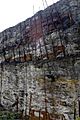
A slag heap in Clarkdale
See also
 In Spanish: Clarkdale para niños
