Verde River facts for kids
Quick facts for kids Verde River |
|
|---|---|

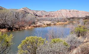
Near Clarkdale along Sycamore Canyon Road
|
|

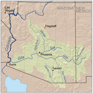
Map of the Gila River watershed, including the Verde River
|
|
| Native name | Haka'he:la |
| Country | United States |
| State | Arizona |
| County | Yavapai, Gila, Maricopa |
| Physical characteristics | |
| Main source | Sullivan Lake near Paulden, Yavapai County 4,354 ft (1,327 m) 34°51′50″N 112°27′39″W / 34.86389°N 112.46083°W |
| River mouth | Salt River near Fountain Hills, Maricopa County 1,325 ft (404 m) 33°32′49″N 111°39′38″W / 33.54694°N 111.66056°W |
| Length | 170 mi (270 km) |
| Basin features | |
| Basin size | 6,615 sq mi (17,130 km2) |
| Tributaries |
|
| Type: | Wild, Scenic |
| Designated: | August 28, 1984 |
The Verde River is a very important river in Arizona. Its name in the Yavapai language is Haka'he:la. It is a main branch of the Salt River. The Verde River is about 170 miles (270 km) long. It is one of the biggest rivers in Arizona that flows all year round.
Contents
What is the Verde River Like?
The Verde River starts below a dam at Sullivan Lake. It gets water from Big Chino Wash and Williamson Valley Wash in Yavapai County. The river flows freely for about 12 miles (19 km). It passes through private lands, state lands, tribal lands, and United States Forest Service areas. This includes the Tonto National Forest.
The river then reaches two dams that create Horseshoe Lake and Bartlett Lake. The main towns along the river are Camp Verde, Clarkdale, and Cottonwood. The Verde River joins the Salt River near Fountain Hills. The Salt River then flows into the Gila River west of Phoenix.
Wild and Scenic River Status
In 1984, the United States Congress decided that about 40.5 miles (65.2 km) of the Verde River should be a "Wild and Scenic River." This is part of the National Wild and Scenic Rivers System.
- The "Scenic" part starts at Beasley Flats and goes downstream about 19 miles (31 km). It ends at the northern edge of the Mazatzal Wilderness.
- The "Wild" part continues from there to the mouth of Red Creek, about 22 miles (35 km) further downstream.
Verde River Greenway State Natural Area
In 1986, the state of Arizona recognized a 6-mile (10 km) section of the river as a very important natural area. This part of the Verde River and its surrounding green areas became a state park. It is called the Verde River Greenway State Natural Area. This park is between the town of Clarkdale and the Bridgeport State Route 89A Bridge. It covers about 480 acres (190 ha). Dead Horse Ranch State Park, near Cottonwood, is also next to this Greenway.
Plants and Animals of the Verde River
The areas along the Verde River are full of different plants and animals. These green areas are called riparian zones.
River Plants
Many kinds of plants grow along the river. These include:
- Arizona alder trees
- Sycamore trees
- Walnut trees
- Different types of willows
- Reeds and cattails
- Box elder trees
- Saltcedar
River Animals
The Verde River is home to many animals that live in or near the water. Some of these are:
- North American beaver
- Belted kingfishers (birds that catch fish)
- Great blue herons (large wading birds)
- Otters
- Chiricahua leopard frogs
- Sonoran mud turtles
There are also 27 different kinds of fish in the river. These include:
- Carp
- Flathead catfish
- Roundtail chub
- Gila chub
- Bass
- Desert sucker
- Mosquitofish
- Red shiner
- Sonora sucker
Beavers and the River
Long ago, in 1829, fur trappers like Ewing Young and Kit Carson caught many beavers on the Verde River. A naturalist named Edgar Alexander Mearns wrote in 1907 that beavers lived in almost all the streams of the Colorado Basin. In more recent times, people have brought beavers back to the river. This has helped even small desert streams become rich habitats for many different plants and animals.
Fun Activities on the Verde River
Floating down the Verde River in rafts and kayaks is a very popular activity. The river flows through beautiful valleys and the Mazatzal Wilderness. The Tonto National Forest takes care of the places where people can access the river.
You can rent kayaks, get shuttle services, and find boating gear in Clarkdale, Cottonwood, and Camp Verde. Many companies offer guided trips on the Verde River. Some popular parts for boating include:
- The Verde River at Clarkdale, starting at the Lower TAPCO River Access Point (RAP) and floating to the Tuzigoot RAP.
- Skidmore RAP to Black Canyon RAP or Bignotti RAP on the Prescott National Forest. This is between Cottonwood and Camp Verde.
- White Bridge RAP to Clear Creek RAP or Beasley Flat RAP on the Prescott National Forest, below Camp Verde.
Fishing in the Verde River
The Verde River is a great place for fishing.
Fishing Above Camp Verde
Above Camp Verde, there are about 70 miles (110 km) of water where you can fish. The average height above sea level here is 3,800 feet (1,200 m). The closest town for supplies like fuel, food, and fishing gear is Cottonwood.
- Fish you might catch: largemouth bass, smallmouth bass, sunfish, channel catfish, flathead catfish, yellow perch, chub, and carp.
- In winter, you might also find rainbow trout.
- Other creatures: Crayfish and bullfrogs.
Fishing from Camp Verde to Horseshoe Lake
From Camp Verde to Horseshoe Lake, there are about 60 miles (97 km) of fishing waters. The average height above sea level is 2,800 feet (850 m). Camp Verde is the closest town for supplies.
- Fish you might catch: Largemouth and smallmouth bass, sunfish, channel and flathead catfish, and carp.
- Other creatures: Crayfish and bullfrogs.
Fishing from Horseshoe Lake to Bartlett Lake
This part of the river is about 12-mile (19 km) long. The average height above sea level is 1,800 feet (550 m). The closest town for supplies is Carefree.
- Fish you might catch: The same types as between Camp Verde and Horseshoe Lake.
Fishing Below Bartlett Lake
Below Bartlett Lake, the river flows for about 20 miles (32 km). The average height above sea level is 1,500 feet (460 m). The closest town for supplies is Fountain Hills.
- Fish you might catch: Largemouth bass, sunfish, channel and flathead catfish, tilapia, carp.
- Other creatures: Crayfish and bullfrogs.
See Also
 In Spanish: Río Verde (Arizona) para niños
 | Stephanie Wilson |
 | Charles Bolden |
 | Ronald McNair |
 | Frederick D. Gregory |

