
Camp Verde, Arizona facts for kids
Quick facts for kids
Camp Verde, Arizona
|
||
|---|---|---|
|
||

Location of Camp Verde in Yavapai County, Arizona
|
||

Camp Verde, Arizona
Location in Arizona

Camp Verde, Arizona
Location in the United States
|
||
| Country | United States | |
| State | Arizona | |
| County | Yavapai | |
| Area | ||
| • Total | 42.36 sq mi (109.70 km2) | |
| • Land | 42.35 sq mi (109.68 km2) | |
| • Water | 0.01 sq mi (0.03 km2) | |
| Elevation | 3,147 ft (959 m) | |
| Population
(2020)
|
||
| • Total | 12,147 | |
| • Density | 286.85/sq mi (110.75/km2) | |
| Time zone | UTC-7 (MST) | |
| ZIP code |
86322
|
|
| Area code(s) | 928 | |
| FIPS code | 04-09690 | |
| GNIS feature ID | 27213 | |
| Website | Town of Camp Verde | |

Camp Verde is a town in Yavapai County, Arizona, United States. In 2010, about 10,873 people lived there. The local Yavapai people call it ʼMatthi:wa, and in Western Apache, it's known as Gambúdih.
Camp Verde hosts several fun events each year. Every summer, the downtown area celebrates the Corn Fest in July. This popular event is put on by local farmers. Other yearly events include the Pecan, Wine and Antiques Festival in February, the Crawdad Festival in June, and Fort Verde Days in October.
Contents
Exploring Camp Verde's Location
Camp Verde covers about 42.6 square miles (110 square kilometers). The main highway, I-17, cuts through the town. You can find the historic downtown area about 1 mile (1.6 km) from I-17. Here, you'll find shops, restaurants, and the Fort Verde State Historic Park.
Where is Camp Verde?
Camp Verde is located in the Verde River valley. To the southwest, you can see the Black Hills mountain range. The town is surrounded by the beautiful Prescott National Forest. Just north of Camp Verde is the Mogollon Rim, which is the edge of the huge Colorado Plateau.
Camp Verde's Weather
Camp Verde has a cold semi-arid climate. This means it has cool winters and very hot summers.
| Climate data for Montezuma Castle National Monument, Arizona, 1991–2020 normals, extremes 1938–present | |||||||||||||
|---|---|---|---|---|---|---|---|---|---|---|---|---|---|
| Month | Jan | Feb | Mar | Apr | May | Jun | Jul | Aug | Sep | Oct | Nov | Dec | Year |
| Record high °F (°C) | 82 (28) |
89 (32) |
96 (36) |
99 (37) |
109 (43) |
117 (47) |
117 (47) |
118 (48) |
111 (44) |
104 (40) |
90 (32) |
78 (26) |
118 (48) |
| Mean maximum °F (°C) | 72.0 (22.2) |
77.1 (25.1) |
85.2 (29.6) |
93.2 (34.0) |
100.3 (37.9) |
108.1 (42.3) |
110.5 (43.6) |
108.0 (42.2) |
102.6 (39.2) |
94.8 (34.9) |
82.5 (28.1) |
71.0 (21.7) |
111.6 (44.2) |
| Mean daily maximum °F (°C) | 60.5 (15.8) |
64.9 (18.3) |
72.0 (22.2) |
79.0 (26.1) |
87.6 (30.9) |
98.1 (36.7) |
100.8 (38.2) |
98.5 (36.9) |
93.0 (33.9) |
82.3 (27.9) |
69.3 (20.7) |
58.6 (14.8) |
80.4 (26.9) |
| Daily mean °F (°C) | 43.2 (6.2) |
47.1 (8.4) |
53.4 (11.9) |
59.5 (15.3) |
67.5 (19.7) |
76.2 (24.6) |
82.4 (28.0) |
80.7 (27.1) |
74.0 (23.3) |
62.5 (16.9) |
50.4 (10.2) |
41.8 (5.4) |
61.6 (16.4) |
| Mean daily minimum °F (°C) | 25.9 (−3.4) |
29.3 (−1.5) |
34.9 (1.6) |
40.0 (4.4) |
47.3 (8.5) |
54.4 (12.4) |
64.0 (17.8) |
62.8 (17.1) |
55.0 (12.8) |
42.6 (5.9) |
31.5 (−0.3) |
25.1 (−3.8) |
42.7 (5.9) |
| Mean minimum °F (°C) | 17.2 (−8.2) |
20.3 (−6.5) |
25.5 (−3.6) |
30.3 (−0.9) |
36.9 (2.7) |
44.2 (6.8) |
54.5 (12.5) |
54.1 (12.3) |
44.7 (7.1) |
32.1 (0.1) |
20.8 (−6.2) |
16.5 (−8.6) |
14.3 (−9.8) |
| Record low °F (°C) | −1 (−18) |
4 (−16) |
12 (−11) |
16 (−9) |
24 (−4) |
36 (2) |
45 (7) |
39 (4) |
31 (−1) |
19 (−7) |
8 (−13) |
4 (−16) |
−1 (−18) |
| Average precipitation inches (mm) | 1.36 (35) |
1.28 (33) |
1.15 (29) |
0.49 (12) |
0.40 (10) |
0.19 (4.8) |
1.52 (39) |
2.13 (54) |
1.49 (38) |
0.95 (24) |
0.71 (18) |
1.50 (38) |
13.17 (335) |
| Average precipitation days (≥ 0.01 inch) | 4.9 | 4.8 | 4.3 | 2.6 | 2.3 | 1.0 | 6.7 | 7.6 | 4.4 | 3.4 | 3.1 | 4.4 | 49.5 |
| Source: NOAA | |||||||||||||
Camp Verde's Growing Population
| Historical population | |||
|---|---|---|---|
| Census | Pop. | %± | |
| 1960 | 285 | — | |
| 1980 | 3,824 | — | |
| 1990 | 6,243 | 63.3% | |
| 2000 | 9,451 | 51.4% | |
| 2010 | 10,873 | 15.0% | |
| 2020 | 12,147 | 11.7% | |
| U.S. Decennial Census | |||
Camp Verde has grown a lot over the years! In 1960, only 285 people lived there. By 1980, the population had jumped to 3,824. The most recent count in 2020 showed that 12,147 people call Camp Verde home.
Fun Things to Do in Camp Verde
There are many cool places to visit in and around Camp Verde!
- Montezuma Castle National Monument: This is a famous ancient cliff dwelling built by early Native Americans.
- Fort Verde State Historic Park: Located right in Camp Verde's historic downtown, this park lets you explore old army buildings and learn about the area's past.
- Verde Valley Archaeology Center: Here you can discover more about the history and cultures of the Verde Valley.
- Out of Africa Wildlife Park: Get up close with amazing animals from around the world at this wildlife park.
- Cliff Castle Casino: This casino is run by the Yavapai-Apache Nation and is a popular spot for entertainment.
Learning in Camp Verde
The Camp Verde Unified School District provides education for students in the community.
Getting Around Camp Verde
You can travel to Camp Verde using Greyhound Lines buses, which connect to cities like Phoenix and Las Vegas. Groome Transportation also offers routes to nearby towns like Sedona and Flagstaff.
Camp Verde is easy to reach by car, as it's located where Interstate 17 and Arizona State Route 260 meet. There's even a small airport in the Montezuma Heights neighborhood.
Historic Buildings and Places
Camp Verde has many historic buildings that tell stories of its past. Some of these are listed on the National Register of Historic Places.
- Historic properties and structures of Camp Verde
(NRHP = National Register of Historic Places)
(CVHS=Verde Camp Verde Historical Society-listed)
-
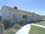
The Administration Building at Fort Verde was built in 1871. It was the main office for the fort and now houses the Visitor Center for the Fort Verde Museum.
-
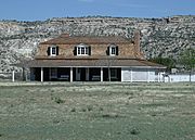
The historic Commanding Officer Quarters at Fort Verde was built in 1871.
-
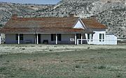
The historic Bachelor Officers’ Quarters at Fort Verde was built in 1871.
-
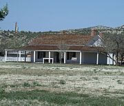
The historic Doctor’s & Surgeons Quarters at Fort Verde was built in 1871.
-

The Wingfield Homestead, also known as "Crooked H Ranch House," was built in 1917.
-

The Don Bell House was built in 1917.
-

The Clear Creek Church was built in 1898. It was the only church in Camp Verde until 1913, then became a school.
-
The George Hance House was built in 1916. George Hance was Camp Verde's first postmaster and an important community leader. This house is now a museum.


See also
 In Spanish: Camp Verde para niños
