
Interstate 17 facts for kids
Quick facts for kids
|
||||
|---|---|---|---|---|
| Arizona Veterans Highway | ||||
|
I-17 highlighted in red
|
||||
| Route information | ||||
| Maintained by ADOT | ||||
| Length | 145.76 mi (234.58 km) | |||
| Existed | 1957–present | |||
| Major junctions | ||||
| South end | ||||
|
||||
| North end | ||||
| Location | ||||
| Counties: | Maricopa, Yavapai, Coconino | |||
| Highway system | ||||
| Main route of the Interstate Highway System Main • Auxiliary • Business State routes in Arizona
|
||||
.svg)
Interstate 17 (I-17) is a major highway in Arizona, United States. It is part of the Interstate Highway System, a network of important roads across the country. I-17 connects the big city of Phoenix in the south to Flagstaff in the north.
This highway is about 145.76 miles (234.58 kilometers) long. It helps people travel between these two major Arizona cities. The road is also known as the Arizona Veterans Highway.
Contents
What is Interstate 17?
Interstate 17 is a busy road that runs through the middle of Arizona. It starts in Phoenix, which is the capital and largest city in Arizona. From there, it heads north, going through different landscapes. The highway ends in Flagstaff, a city known for its cooler weather and nearby mountains.
The Interstate Highway System was created to make travel easier and faster across the United States. I-17 is a key part of this system in Arizona. It helps connect people and goods between the southern and northern parts of the state.
Where Does I-17 Go?
Interstate 17 travels through three different counties in Arizona. It begins in Maricopa County, where Phoenix is located. As you drive north, it enters Yavapai County. Finally, it reaches Coconino County, where Flagstaff is found.
Along its path, I-17 connects with several other important roads. In Phoenix, it meets with Interstate 10 and U.S. Route 60. These connections help drivers get to many different places. Further north, it links up with state routes like SR 69 and SR 260.
Journey from Phoenix to Flagstaff
Driving on I-17 from Phoenix to Flagstaff is an interesting trip. You start in the desert heat of Phoenix. As you go north, the elevation slowly increases. This means you are driving uphill. The scenery changes from desert plants to more trees and mountains.
Near Cordes Lakes, the road starts to climb more noticeably. You pass through areas like Camp Verde. The air gets cooler as you get closer to Flagstaff. This city is at a much higher elevation than Phoenix.
Views Along the Way
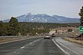
The drive offers some amazing views. South of Munds Park, you can often see the beautiful Red Rocks of Sedona. These are famous red rock formations that stand out against the sky. As you get closer to Flagstaff, you'll see more pine trees. This is a big change from the desert landscape you started in.
The highway is important for tourism. Many people use I-17 to visit places like Sedona, the Grand Canyon, and the national forests around Flagstaff. It's a popular route for both locals and visitors.
History of Interstate 17
Interstate 17 was first established in 1957. This means that plans for the highway began around that time. Building a major highway like I-17 takes many years. It involves a lot of planning, construction, and engineering work.
Over the years, parts of the highway have been improved and expanded. This helps to handle the increasing amount of traffic. As Arizona's population grows, so does the need for good roads. I-17 continues to be a vital transportation route for the state.
Images for kids
-
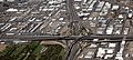
"The Stack", intersection of I-10 and I-17. Looking north up I-17, downtown Phoenix.
-

Southern terminus at I-10 in Phoenix
-

View of the Red Rocks of Sedona from I-17, just south of Munds Park
-
I-17 near Flagstaff
-
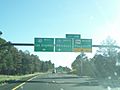
Northern terminus at I-40 in Flagstaff


See also
 In Spanish: Interestatal 17 para niños
