
Mogollon Rim facts for kids
The Mogollon Rim (say it like "mug-ee-YOHN" or "moh-guh-YOHN") is a huge natural cliff that stretches across the northern part of Arizona, a state in the United States. It's about 200 miles (320 km) long, starting in Yavapai County and going east towards the border of New Mexico. This amazing cliff forms the southern edge of the Colorado Plateau, a large, high area of flat land.
Contents
What is the Mogollon Rim?
The Mogollon Rim is a giant cliff, also called an escarpment. It marks the southwestern edge of the Colorado Plateau. The most impressive parts of the Rim have tall cliffs made of limestone and sandstone. These rocks are known as the Kaibab Limestone and Coconino Sandstone.
The Rim was formed over millions of years by erosion (when wind and water wear away rock) and faulting (when the Earth's crust breaks and moves). This process created deep canyons like Fossil Creek Canyon and Pine Canyon. The name "Mogollon" comes from Don Juan Ignacio Flores Mogollón, who was a Spanish Governor of New Mexico a long time ago, from 1712 to 1715.
How High is the Mogollon Rim?
Much of the land south of the Mogollon Rim is about 4,000 to 5,000 feet (1,200 to 1,500 meters) above sea level. But the cliff itself rises even higher, reaching about 8,000 feet (2,400 meters) in some places!
Plants and Animals of the Rim
You'll find huge Ponderosa pine forests growing both on the slopes of the Rim and on the flat land of the Colorado Plateau to the north. The Mogollon Rim is like a natural dividing line for plants and animals. Species that usually live in the Rocky Mountains can be found on top of the plateau. Below the Rim, and in the "Madrean Sky Islands" (which are high, isolated mountain ranges further south), you'll find species native to the Mexican Sierra Madre Occidental.
Rocks and Geology of the Rim
The limestone and sandstone rocks of the Mogollon Rim were formed from sediments that settled down during the Carboniferous and Permian Periods. Some of these same rock layers can also be seen on the walls of the famous Grand Canyon. In many areas, the top of the Rim is covered by large flows of basaltic lava from ancient volcanoes.
The very top layer of sandstone on the Mogollon Rim is called the Coconino Sandstone. This rock forms white cliffs that can be hundreds of feet tall. This sandstone formed during the Permian Period from sand blown by the wind (called aeolian origin). It's one of the thickest sand-dune-derived sandstones found anywhere on Earth!
Cities and Wildfires Near the Rim
Several cities and towns are located near the Mogollon Rim. These include Payson, Sedona, Show Low, Alpine, and Pinetop-Lakeside. The main highway, Interstate 17, cuts right through the Mogollon Rim as it runs between Flagstaff and Phoenix.
Major Wildfires in the Area
The Mogollon Rim has unfortunately been the site of large wildfires. In June 2002, the eastern part of the Rim experienced Arizona's second-largest wildfire, called the Rodeo–Chediski Fire. This fire burned over 470,000 acres (1,900 km²).
Another big fire, the Dude fire, started on June 25, 1990. This fire grew to cover more than 30,000 acres (120 km²) and tragically caused the death of six wildland firefighters. Since 1990, other large fires have also burned along the Mogollon Rim. The Ponderosa pine forests in this area are still at risk because of past efforts to stop fires, which led to a buildup of dry fuel that can easily burn.
Famous Writers and the Rim
The famous Western novel author Zane Grey built a hunting cabin on the slopes of the Mogollon Rim, just northeast of Payson, above Tonto Creek. The cabin was fixed up in the late 1960s, but sadly, it was destroyed by the Dude Fire in 1990.
Another well-known author, Louis L'Amour, wrote a novel called The Sackett Brand. This story is set near the Mogollon Rim and includes descriptions of its impressive cliffs.
Images for kids
-
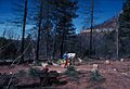
Site of Zane Grey's lodge

See also
 In Spanish: Borde Mogollón para niños
