
Fossil Creek facts for kids
Quick facts for kids Fossil Creek |
|
|---|---|
.jpg)
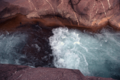
Waterfall on Fossil Creek
|
|

Fossil Creek proposal map (March 2011)
|
|

Location of the mouth of
Fossil Creek at the Verde River |
|
| Native name | Hakhavsuwa |
| Country | United States |
| State | Arizona |
| County | Coconino, Yavapai, Gila |
| City | Strawberry |
| Physical characteristics | |
| Main source | 6,510 ft (1,980 m) 34°26′07″N 111°30′31″W / 34.43528°N 111.50861°W |
| River mouth | Verde River 2,543 ft (775 m) 34°18′21″N 111°40′32″W / 34.30583°N 111.67556°W |
| Length | 17 mi (27 km) |
| Basin features | |
| Basin size | 135 sq mi (350 km2) |
| Type: | Wild, Recreational |
| Designated: | March 30, 2009 |
Fossil Creek (also known as Hakhavsuwa or Vialnyucha by the Yavapai people) is a beautiful stream in Arizona, USA. It's called "Fossil Creek" because its rocks and plants often look like fossils. This happens because they get covered in a mineral called travertine.
This amazing creek is special because it flows all year round. It starts high up on the Mogollon Rim and eventually joins the larger Verde River. Fossil Creek is one of only two streams in Arizona that are part of the National Wild and Scenic Rivers System. This means it's protected for its natural beauty and importance.
The water in Fossil Creek comes from Fossil Springs, which pours out a huge amount of water every minute! This water is always a constant temperature, around 72 degrees Fahrenheit (22 degrees Celsius). As the water flows, it creates natural dams and deposits of travertine. In fact, Fossil Creek is the fourth largest producer of travertine in the entire United States.
Because it's so unique, Fossil Creek is home to many different plants and animals. Some of these species are rare or even endangered. To protect this special place, there are rules about visiting, like needing a permit to park during certain times of the year.
Contents
Journey of Fossil Creek
Fossil Creek begins at Fossil Springs, high up on the Mogollon Rim in Coconino County. This is north of a town called Strawberry. At first, the creek's flow can be a bit stop-and-go for about 3 miles (5 km).
As it flows, the creek generally heads north, quickly entering Gila County. It then turns west, and from this point on, it forms the border between Gila County and Yavapai County all the way to the Verde River.
The parts of the creek that flow all the time start at Fossil Springs. From here, the creek flows west and southwest. You can even see the remains of an old dam along the way. Forest Road 708, also known as Fossil Creek Road, follows the creek for about 2.5 miles (4 km) and crosses it once at Fossil Creek Bridge.
Later, Fossil Creek makes a sharp turn south. It then turns west again before finally joining the Verde River.
How Much Water Flows?
The water flowing from Fossil Springs is very steady. It's estimated to be between 43 to 56 cubic feet per second (320–420 gallons per second) all year long. The water also comes out of the ground at a constant 72 degrees Fahrenheit (22 degrees Celsius).
The United States Geological Survey started measuring the water flow at Fossil Creek Bridge in 2010. The most water recorded there in a single day was 885 cubic feet per second (25 cubic meters per second) on February 19, 2011. The least amount recorded was 39 cubic feet per second (1.1 cubic meters per second) on August 6, 2011.
Amazing Geology of Fossil Creek
Fossil Creek Canyon is quite deep, about 1,600 feet (490 meters). Its width changes, from about 2 miles (3 km) wide near Fossil Springs to less than 1 mile (1.6 km) in some places further downstream. The rocks in the canyon are very old, dating back millions of years.

Fossil Springs provides about 80 percent of the water in Fossil Creek. The water comes from several openings at the bottom of the Mogollon Rim. This rim is the southern edge of the Colorado Plateau. As water seeps through layers of limestone in the rim, it picks up dissolved carbon dioxide and calcium carbonate.
When this water comes out at the springs, it starts to release carbon dioxide gas. This causes the calcium carbonate to form travertine. Travertine is a type of calcite that looks porous, like a sponge. You can often find it around hot springs, like those in Yellowstone National Park. This process of travertine forming doesn't happen all at once; it continues as the water flows downstream.
In the 1800s, people noticed many natural travertine dams with deep pools behind them along the creek. A study in 1996 found the remains of at least 80 such dams. After the creek's natural flow was brought back in 2008, hundreds of new travertine dams began to form. About 13 tons (12 metric tons) of travertine are deposited along the stream every day! This makes Fossil Creek the fourth largest travertine system in the United States.
History of Fossil Creek
Early History and Naming
Archaeologists have found signs that people lived in the Fossil Creek area as far back as 10,000 years ago. More recently, the Yavapai and Apache peoples lived here. In the 1800s, cattle ranchers and shepherds also used the area.
Fossil Creek first appeared on maps in Arizona in the 1860s. This was when Arizona Territory's first governor, John Noble Goodwin, traveled through the region. His group saw rocks and twigs covered in travertine, which looked like fossils. This is how the creek got its name, Fossil Creek.
Hydroelectric Power Plants
Fossil Creek's strong and steady flow made it a good place to produce electricity. In the early 1900s, people saw its potential to power copper mines in Jerome and gold and silver mines in the Bradshaw Mountains.
In 1908, construction began on a hydropower plant called Childs on the Verde River. This project included building a 25-foot (7.6-meter) high dam across Fossil Creek. Water was then carried from the dam to the Childs plant through long concrete channels called flumes. There was also an artificial lake, Stehr Lake, which held enough water to keep the plant running for several days if the flume system needed to be shut down. In 1916, a second plant, the Irving Power Plant, was built along Fossil Creek.
The Childs-Irving complex was Arizona's first hydroelectric power plant. By 1920, it was providing up to 70 percent of the power used by Phoenix. This complex was recognized as an important historical site.
Bringing the Stream Back to Life
In 2004, efforts began to remove plants and animals that were not native to the creek. This helped native fish survive better. A special barrier was also put in place to stop non-native species from swimming further upstream.
In 2005, the power company decided to close both power plants. They realized the plants weren't producing much electricity anymore, and restoring the creek would be a great benefit. In 2008, the diversion dam was removed, allowing Fossil Creek to flow naturally again.
In 2009, President Barack Obama signed a law that made Fossil Creek a National Wild and Scenic River. This was after a long campaign by the Arizona Nature Conservancy. This law protects 16.8 miles (27 km) of the stream. Fossil Creek is one of only two streams in Arizona with these special "Wild and Scenic" protections.
Animals and Plants of Fossil Creek

The creek and the area around it are home to about 200 different kinds of birds, mammals, reptiles, and amphibians. This includes many special species, like the southwestern willow flycatcher and the Chiricahua leopard frog.
The Fossil Creek area supports 27 types of birds that migrate from warmer places, like the sage sparrow. It also has 20 species, such as the common black hawk, that are considered sensitive by the U.S. Forest Service. Mammals you might find here include otters, beavers, and various bats. Among the reptiles and amphibians are the Arizona toad and the unique reticulated Gila monster.
Fish and Invertebrates
Native fish living in Fossil Creek include the headwater chub, roundtail chub, speckled dace, longfin dace, Sonora sucker, and desert sucker. Between 2007 and 2010, wildlife agencies added more native fish like spikedace, loach minnows, Gila topminnows, and razorback suckers. All of these, except for the speckled dace, are special-status fish, meaning they are endangered, threatened, or sensitive.
More than 100 types of macroinvertebrates (small creatures without backbones) also live in the Fossil Creek area. One of these, the fossil springsnail, is listed as sensitive by the U.S. Forest Service.
Plants and Trees
The areas along Fossil Creek provide excellent homes for native plants. These include trees like the Arizona alder and Fremont cottonwood. You can also find many different shrubs, grasses, ferns, and other smaller plants. There are more types of plants above where the old power-plant dam used to be, especially near Fossil Springs.
In 1987, a 26-acre (11-hectare) area above the dam was set aside as the Fossil Springs Botanical Area. Plant surveys between 2003 and 2005 found 166 plant species in this botanical area and 314 species of flowering plants and ferns in the wider Fossil Creek area.
Fun Activities at Fossil Creek
Fossil Creek's steady flow, warm water, deep pools, and small waterfalls make it a popular spot for visitors. People love to wade, swim, float, kayak, and snorkel in its clear waters.
There are also four main hiking trails in the Fossil Creek area: the Flume–Irving, Fossil Springs, Mail, and Deadman Mesa trails. The U.S. Forest Service allows camping in some parts of the area. However, some sensitive areas, like those right next to the water, are off-limits for overnight stays. Other fun activities include watching wildlife, taking photos, fishing, and visiting the remains of the old power plant buildings.
Since the stream was restored, Fossil Creek has become very popular, especially since it's only about a two-hour drive from Phoenix. Because so many people visit, there have been some problems with trash and damage to the forests and stream banks.
The main way to get there is by Forest Road 708 (Fossil Creek Road) off Arizona State Route 260 east of Camp Verde. This road is about 22 miles (35 km) long, with some paved and some unpaved sections. The Forest Service sometimes closes parts of Forest Road 708 due to bad weather or safety concerns. Campfires are not allowed in certain areas, and other rules apply.
To help manage the number of visitors, you now need a special permit to park at Fossil Creek between April 1 and October 1. These permits are available online about a month in advance. Since 2009, the Forest Service has been working on a detailed plan to manage Fossil Creek and keep it beautiful for everyone.
Images for kids
-
Lower Fossil Creek, 2008

