
Tuzigoot National Monument facts for kids
Quick facts for kids Tuzigoot National Monument |
|
|---|---|
|
IUCN Category III (Natural Monument)
|
|

Part of the Tuzigoot pueblo
|
|

Tuzigoot National Monument
Location in Arizona

Tuzigoot National Monument
Location in the United States
|
|
| Location | Yavapai County, Arizona, US |
| Nearest city | Cottonwood, Arizona |
| Area | 811.89 acres (328.56 ha) |
| Created | July 25, 1939 |
| Visitors | 98,090 (in 2018) |
| Governing body | National Park Service |
| Website | Tuzigoot National Monument |
Tuzigoot National Monument is a special place that protects the remains of an ancient village. This village, called a pueblo, was built on top of a rocky hill. It stands about 120 feet above the Verde River in Clarkdale, Arizona.
The village is a long group of stone rooms built along the natural shape of the hill. Some rooms in the middle were taller. They might have been used for important community gatherings. This pueblo had 110 rooms! The National Park Service looks after about 58 acres of this land today.
The name "Tuzigoot" comes from the Tonto Apache language. It means "crooked waters," probably because of a nearby lake called Pecks Lake. The Sinagua people built this village between the years 1125 and 1400. It's the biggest and best-kept Sinagua village in the whole Verde Valley. This village had very few doors. Instead, people used ladders to climb through openings in the roofs to get into each room.
Contents
Discovering Tuzigoot's Past
The land where Tuzigoot stands was once owned by a mining company. They sold the site to Yavapai County for just $1. This allowed archaeologists to dig up and study the ruins. The county then gave the land to the federal government.
Excavation and Preservation
From 1933 to 1935, experts like Louis Caywood and Edward Spicer from the University of Arizona excavated Tuzigoot. They had help from federal programs like the Civil Works Administration. After the digging, the ruins were made ready for people to visit. A museum and visitor center were built in a style that looks like old pueblos.
Becoming a National Monument
On July 25, 1939, President Franklin D. Roosevelt officially made Tuzigoot a U.S. National Monument. This means it's a special place protected by the government. Later, in 1966, the Tuzigoot National Monument Archeological District was added to the National Register of Historic Places. This list helps protect important historical sites.
Climate at Tuzigoot
Tuzigoot National Monument has a semi-arid climate. This means it has cool winters and very hot summers.
| Climate data for Tuzigoot National Monument, Arizona, 1991–2020 normals, extremes 1920–present | |||||||||||||
|---|---|---|---|---|---|---|---|---|---|---|---|---|---|
| Month | Jan | Feb | Mar | Apr | May | Jun | Jul | Aug | Sep | Oct | Nov | Dec | Year |
| Record high °F (°C) | 80 (27) |
87 (31) |
92 (33) |
98 (37) |
107 (42) |
118 (48) |
116 (47) |
114 (46) |
113 (45) |
102 (39) |
89 (32) |
79 (26) |
118 (48) |
| Mean maximum °F (°C) | 71.5 (21.9) |
74.9 (23.8) |
82.5 (28.1) |
91.3 (32.9) |
99.5 (37.5) |
108.1 (42.3) |
109.9 (43.3) |
106.7 (41.5) |
100.8 (38.2) |
92.5 (33.6) |
81.8 (27.7) |
71.3 (21.8) |
111.3 (44.1) |
| Mean daily maximum °F (°C) | 60.9 (16.1) |
64.5 (18.1) |
71.2 (21.8) |
78.9 (26.1) |
87.9 (31.1) |
98.9 (37.2) |
101.1 (38.4) |
98.4 (36.9) |
93.1 (33.9) |
82.6 (28.1) |
70.5 (21.4) |
59.8 (15.4) |
80.6 (27.0) |
| Daily mean °F (°C) | 45.3 (7.4) |
48.6 (9.2) |
54.4 (12.4) |
61.0 (16.1) |
69.4 (20.8) |
79.1 (26.2) |
83.9 (28.8) |
82.0 (27.8) |
75.7 (24.3) |
64.7 (18.2) |
53.3 (11.8) |
44.6 (7.0) |
63.5 (17.5) |
| Mean daily minimum °F (°C) | 29.8 (−1.2) |
32.7 (0.4) |
37.6 (3.1) |
43.0 (6.1) |
50.8 (10.4) |
59.3 (15.2) |
66.8 (19.3) |
65.5 (18.6) |
58.4 (14.7) |
46.7 (8.2) |
36.0 (2.2) |
29.4 (−1.4) |
46.3 (7.9) |
| Mean minimum °F (°C) | 20.9 (−6.2) |
23.2 (−4.9) |
28.4 (−2.0) |
33.6 (0.9) |
40.1 (4.5) |
49.6 (9.8) |
59.3 (15.2) |
59.1 (15.1) |
49.0 (9.4) |
36.0 (2.2) |
25.2 (−3.8) |
20.1 (−6.6) |
17.8 (−7.9) |
| Record low °F (°C) | 5 (−15) |
6 (−14) |
14 (−10) |
24 (−4) |
29 (−2) |
40 (4) |
52 (11) |
46 (8) |
41 (5) |
21 (−6) |
8 (−13) |
8 (−13) |
5 (−15) |
| Average precipitation inches (mm) | 1.10 (28) |
0.99 (25) |
1.01 (26) |
0.43 (11) |
0.42 (11) |
0.18 (4.6) |
1.64 (42) |
2.15 (55) |
1.30 (33) |
0.96 (24) |
0.70 (18) |
1.12 (28) |
12.00 (305) |
| Average snowfall inches (cm) | 0.2 (0.51) |
0.1 (0.25) |
0.1 (0.25) |
0.2 (0.51) |
0.0 (0.0) |
0.0 (0.0) |
0.0 (0.0) |
0.0 (0.0) |
0.0 (0.0) |
0.0 (0.0) |
0.1 (0.25) |
0.3 (0.76) |
1.0 (2.5) |
| Average precipitation days (≥ 0.01 inch) | 4.6 | 5.2 | 4.7 | 2.7 | 2.5 | 1.3 | 7.5 | 8.4 | 4.9 | 3.6 | 3.1 | 4.4 | 52.9 |
| Average snowy days (≥ 0.1 inch) | 0.2 | 0.2 | 0.1 | 0.1 | 0.0 | 0.0 | 0.0 | 0.0 | 0.0 | 0.0 | 0.0 | 0.2 | 0.8 |
| Source: NOAA | |||||||||||||
Images for kids
-
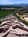
Tuzigoot National Monument
-
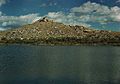
Tuzigoot, viewed from across the old tailings pond, 1945
-
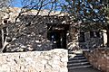
Tuzigoot Museum


.jpg)
See also
- National Register of Historic Places listings in Yavapai County, Arizona
- List of historic properties in Clarkdale, Arizona
- List of national monuments of the United States
