Mohave County, Arizona facts for kids
Quick facts for kids
Mohave County
|
||
|---|---|---|

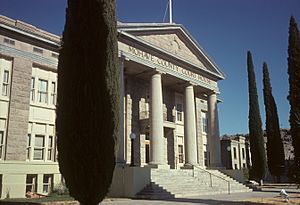
Mohave County Courthouse in Kingman
|
||
|
||

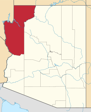
Location within the U.S. state of Arizona
|
||
 Arizona's location within the U.S. |
||
| Country | ||
| State | ||
| Founded | November 9, 1864 | |
| Named for | Fort Mohave | |
| Seat | Kingman | |
| Largest city | Lake Havasu City | |
| Area | ||
| • Total | 13,461 sq mi (34,860 km2) | |
| • Land | 13,311 sq mi (34,480 km2) | |
| • Water | 150 sq mi (400 km2) 1.1% | |
| Population
(2020)
|
||
| • Total | 213,267 | |
| • Estimate
(2023)
|
223,682 |
|
| • Density | 15.8433/sq mi (6.11714/km2) | |
| Time zone | UTC−7 (Mountain) | |
| Congressional districts | 2nd, 9th | |
Mohave County is a large county located in the northwest part of Arizona, a state in the United States. In 2020, about 213,267 people lived here. The main city and county seat is Kingman. The biggest city in the county is Lake Havasu City. Mohave County is one of the largest counties in the entire United States by land area.
This county is part of a larger area called the Lake Havasu City–Kingman, Arizona Metropolitan Statistical Area. It also connects to the Las Vegas-Henderson, Nevada-Arizona Combined Statistical Area.
Mohave County is home to parts of famous places like Grand Canyon National Park and Lake Mead National Recreation Area. It also includes all of the Grand Canyon–Parashant National Monument. You can also find parts of the Kaibab, Fort Mojave, and Hualapai Indian Reservations within the county's borders.
Contents
History of Mohave County
Mohave County was one of the first four counties created in Arizona. This happened on November 9, 1864, by the first Arizona Territorial Legislature. Its original borders were set to the west of a certain longitude and north of the Bill Williams River.
In 1865, a new county called Pah-Ute County was formed from part of Mohave County. However, in 1871, Pah-Ute County was merged back into Mohave County. This happened after a lot of its land was given to Nevada in 1866. The county's current borders were decided in 1881.
Mohave County has had five different county seats, which are the main towns where the county government is located:
- Mohave City (1864–1867)
- Hardyville (1867–1873)
- Cerbat (1873–1877)
- Mineral Park (1877–1887)
- Kingman (1887–present)
Geography and Natural Wonders
Mohave County covers a huge area of about 13,461 square miles. Most of this (13,311 square miles) is land, and about 150 square miles (1.1%) is water. It is the second-largest county in Arizona. It is also the fifth-largest county in the contiguous United States (the 48 states that touch each other).
The county is split into two parts by the amazing Grand Canyon. There is no direct road that connects these two sections.
- The northern part is smaller and has fewer people. It's part of the Arizona Strip and borders Utah and Nevada.
- The larger southern part borders Nevada and California. The Colorado River forms most of its western edge. This southern section includes Kingman, the county seat, and other cities. It also has a large part of the Mojave Desert.
Neighboring Counties
Mohave County shares borders with many other counties:
- Washington County, Utah – to the north
- Kane County, Utah – to the northeast
- Coconino County – to the east
- Yavapai County – to the east
- La Paz County – to the south
- San Bernardino County, California – to the southwest
- Clark County, Nevada – to the west
- Lincoln County, Nevada – to the northwest
Together, Mohave County and its neighbors form a very large area. This combined land is bigger than the entire state of Idaho. It includes some of the biggest counties outside of Alaska.
Protected Natural Areas
Mohave County is home to many beautiful protected natural areas. These areas help protect wildlife and nature.
- Bill Williams River National Wildlife Refuge (part)
- Grand Canyon National Park (part)
- Grand Canyon–Parashant National Monument
- Havasu National Wildlife Refuge (part)
- Kaibab National Forest (part)
- Lake Mead National Recreation Area (part)
- Pipe Spring National Monument
There are also 18 official wilderness areas in Mohave County. These are special places where nature is kept wild and untouched. Most of these are managed by the Bureau of Land Management. Some are part of the larger protected areas listed above.
Population and People
| Historical population | |||
|---|---|---|---|
| Census | Pop. | %± | |
| 1870 | 179 | — | |
| 1880 | 1,190 | 564.8% | |
| 1890 | 1,444 | 21.3% | |
| 1900 | 3,426 | 137.3% | |
| 1910 | 3,773 | 10.1% | |
| 1920 | 5,259 | 39.4% | |
| 1930 | 5,572 | 6.0% | |
| 1940 | 8,591 | 54.2% | |
| 1950 | 8,510 | −0.9% | |
| 1960 | 7,736 | −9.1% | |
| 1970 | 25,857 | 234.2% | |
| 1980 | 55,865 | 116.1% | |
| 1990 | 93,497 | 67.4% | |
| 2000 | 155,032 | 65.8% | |
| 2010 | 200,186 | 29.1% | |
| 2020 | 213,267 | 6.5% | |
| 2023 (est.) | 223,682 | 11.7% | |
| U.S. Decennial Census 1790–1960 1900–1990 1990–2000 2010–2020 |
|||
In 2010, there were 200,186 people living in Mohave County. There were 82,539 households and 54,036 families. The county had about 15 people per square mile.
Most people in the county (86.9%) were white. About 2.2% were American Indian, and 1.1% were Asian. People of Hispanic or Latino origin made up 14.8% of the population. Many people had German (23.1%), Irish (16.2%), or English (15.6%) backgrounds.
About 24.5% of households had children under 18 living with them. The average age of people in Mohave County was 47.6 years old.
The average income for a household was $39,785. For families, it was $47,530. About 16.1% of the population lived below the poverty line. This included 24.7% of those under 18 years old.
Education in Mohave County
Mohave County has many schools and colleges for students of all ages.
K-12 Schools
Several school districts serve students from kindergarten through 12th grade:
- Unified School Districts (K-12)
- Colorado City Unified School District
- Fredonia-Moccasin Unified District
- Kingman Unified School District
- Lake Havasu Unified School District
- Littlefield Unified School District
- Peach Springs Unified School District (high school students go to other districts)
- High School Districts
- Colorado River Union High School District
- Elementary School Districts (K-8)
- Bullhead City Elementary School District
- Hackberry School District
- Mohave Valley Elementary School District
- Owens-Whitney Elementary School District
- Topock Elementary School District
- Valentine Elementary School District
- Yucca Elementary School District
There is also a charter school called Kingman Academy of Learning.
Colleges and Higher Education
For students who want to continue their education after high school, Mohave County offers:
- Mohave Community College
- Arizona State University Lake Havasu City Campus
Public Libraries
The Mohave County Library system has ten different branches. These libraries offer books, computers, and other resources for everyone. The branches in Bullhead City, Kingman, and Lake Havasu City are open for many hours each week.
Getting Around Mohave County
Main Roads and Highways
Airports
Mohave County has several public airports. These airports help people travel by air and connect the county to other places.
- Bullhead City – Eagle Airpark (A09)
- Bullhead City – Laughlin-Bullhead International Airport (IFP)
- Bullhead City – Sun Valley Airport (A20)
- Colorado City – Colorado City Municipal Airport (AZC)
- Kingman – Kingman Airport (IGM)
- Lake Havasu City – Lake Havasu City Airport (HII)
- Meadview – Pearce Ferry Airport (L25)
- Peach Springs – Grand Canyon West Airport (1G4)
- Temple Bar – Temple Bar Airport (U30)
Cities, Towns, and Communities
Mohave County has several cities, one town, and many smaller communities.
Cities
- Bullhead City
- Kingman (This is the county seat)
- Lake Havasu City
Town
Census-Designated Places (CDPs)
These are areas that are like towns but are not officially incorporated as cities or towns.
- Antares
- Arizona Village
- Beaver Dam
- Cane Beds
- Centennial Park
- Chloride
- Clacks Canyon
- Crozier
- Crystal Beach
- Desert Hills
- Dolan Springs
- Fort Mohave
- Golden Shores
- Golden Valley
- Grand Canyon West
- Hackberry
- Kaibab
- Katherine
- Lazy Y U
- Littlefield
- McConnico
- Meadview
- Mesquite Creek
- Moccasin
- Mohave Valley
- Mojave Ranch Estates
- New Kingman-Butler
- Oatman
- Peach Springs
- Pine Lake
- Pinion Pines
- Scenic
- So-Hi
- Topock
- Truxton
- Valentine
- Valle Vista
- Walnut Creek
- White Hills
- Wikieup
- Willow Valley
- Yucca
Ghost Towns
These are towns that used to be active but are now mostly abandoned.
- Alamo Crossing
- Aubrey Landing
- Camp Beale Springs
- Cedar
- Cerbat
- Cottonia
- Cyclopic
- Fort Mohave
- Frisco
- Germa
- Golconda
- Gold Basin
- Goldflat
- Goldroad
- Grand Gulch
- Grasshopper Junction
- Greenwood City
- Hardyville
- Henning
- Lincolnia
- Liverpool Landing
- Lost Basin
- Macnab
- McCracken
- Mellen
- Mineral City
- Mineral Park
- Mockingbird
- Mohave City
- Mount Trumbull
- Nothing
- Old Trails
- Pearce Ferry
- Polhamus Landing
- Powell
- Pyramid
- Sandy
- Santa Claus
- Signal
- Snowball
- Stockton
- Tuweep
- Virginia City
- Vivian
- Willow Ranch
- Wolf Hole
Native American Communities
Population Ranking of Communities
This table shows the population of the main communities in Mohave County, based on the 2010 census. † indicates the county seat.
| Rank | City/Town/etc. | Population (2010 Census) | Type of Community | Year Incorporated |
|---|---|---|---|---|
| 1 | Lake Havasu City | 52,527 | City | 1978 |
| 2 | Bullhead City | 39,540 | City | 1984 |
| 3 | † Kingman | 28,068 | City | 1952 |
| 4 | Fort Mohave | 14,364 | CDP | |
| 5 | New Kingman-Butler | 12,134 | CDP | |
| 6 | Golden Valley | 8,370 | CDP | |
| 7 | Colorado City | 4,821 | City | 1913 (founded) |
| 8 | Mohave Valley | 2,616 | CDP | |
| 9 | Desert Hills | 2,245 | CDP | |
| 10 | Golden Shores | 2,047 | CDP | |
| 11 | Dolan Springs | 2,033 | CDP | |
| 12 | Beaver Dam | 1,962 | CDP | |
| 13 | Valle Vista | 1,659 | CDP | |
| 14 | Scenic | 1,643 | CDP | |
| 15 | Centennial Park | 1,264 | CDP | |
| 16 | Meadview | 1,224 | CDP | |
| 17 | Peach Springs | 1,090 | CDP | |
| 18 | Willow Valley | 1,062 | CDP | |
| 19 | Arizona Village | 946 | CDP | |
| 20 | Walnut Creek | 562 | CDP | |
| 21 | So-Hi | 477 | CDP | |
| 22 | Cane Beds | 448 | CDP | |
| 23 | Lazy Y U | 428 | CDP | |
| 24 | Mesquite Creek | 416 | CDP | |
| 25 | White Hills | 323 | CDP | |
| 26 | Littlefield | 308 | CDP | |
| 27 | Crystal Beach | 279 | CDP | |
| 28 | Chloride | 271 | CDP | |
| 29 | Pinion Pines | 186 | CDP | |
| 30 | Clacks Canyon | 173 | CDP | |
| 31 | Pine Lake | 138 | CDP | |
| 32 | Oatman | 135 | CDP | |
| 33 | Truxton | 134 | CDP | |
| 34 | Wikieup | 133 | CDP | |
| t-35 | Antares | 126 | CDP | |
| t-35 | Yucca | 126 | CDP | |
| 36 | Kaibab (partially in Coconino County) | 124 | CDP | |
| 37 | Katherine | 103 | CDP | |
| 38 | Moccasin | 89 | CDP | |
| 39 | McConnico | 70 | CDP | |
| 40 | Hackberry | 68 | CDP | |
| 41 | Mojave Ranch Estates | 52 | CDP | |
| 42 | Valentine | 38 | CDP | |
| 43 | Crozier | 14 | CDP | |
| 44 | Topock | 10 | CDP | |
| 45 | Grand Canyon West | 2 | CDP |
Economy and Resources
Mining in Mohave County
Mining has been an important part of Mohave County's economy. One notable mining area is the Artillery Peak mine.
See also
 In Spanish: Condado de Mohave para niños
 | Toni Morrison |
 | Barack Obama |
 | Martin Luther King Jr. |
 | Ralph Bunche |


