Cane Beds, Arizona facts for kids
Quick facts for kids
Cane Beds, Arizona
|
|
|---|---|

Cane Beds Road in 2004
|
|
| Country | |
| State | |
| County | Mohave |
| Area | |
| • Total | 8.29 sq mi (21.46 km2) |
| • Land | 8.29 sq mi (21.46 km2) |
| • Water | 0.00 sq mi (0.00 km2) |
| Elevation | 5,046 ft (1,538 m) |
| Population
(2020)
|
|
| • Total | 466 |
| • Density | 56.25/sq mi (21.72/km2) |
| Time zone | UTC-7 (MST) |
| ZIP Code |
86022
|
| FIPS code | 04-09900 |
| GNIS feature ID | 2582747 |
Cane Beds is a small community in Mohave County, Arizona, United States. It is known as a census-designated place (CDP), which means it's a special area defined for gathering population data.
Cane Beds is located about 4 miles (6.4 km) south of the Utah border. It's part of a region called the Arizona Strip. Many services for the community come from Utah and even some from Nevada. In 2020, about 466 people lived there. The community has historical ties to Mormon settlers. Today, it also includes families from other Mormon groups. Cane Beds has a small tourism industry because of the beautiful hiking trails nearby.
Contents
What's in a Name?
The name "Cane Beds" comes from the wild cane that grows naturally in the area. Early settlers found large patches of this cane. A resident named Annie W. Wilkinson explained that "beds of wild cane" were common when people first arrived. You can still find some cane growing there today.
Long ago, the area was sometimes called "Cain Patch." A creek and a spring in the area also share this name. The Southern Paiute people, who lived here before, called the area "Paɣáŋq`ʷtonƐnįnto`." This name means "cane valley" in their language.
A Look at History

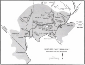
For a long time, until the 1900s, the land where Cane Beds is now was home to the Southern Paiute people. Their territory included this area, as shown on maps from 1934. Archeologists have found ancient sites here from the Paiute, Archaic, and Anasazi cultures.
The Arizona Strip was often overlooked by the government in the past. This meant that early settlers, especially Mormons, explored the land themselves. John D. Lee and other pioneers visited the area in 1852 and 1858. They might have called Cane Beds "Virgin Bottoms" because it was a valley near the Virgin River.
The town of Cane Beds was officially started in 1868. By 1876, Mormon settlers had fully made it their home. The town was located along an important trail. This trail led from Lees Ferry to the first Mormon temple in Utah. Many Mormon settlers used this path. A post office was opened in Cane Beds on June 15, 1917. Cora H. Cox was the first postmistress.
Over time, different groups of Mormons settled in Cane Beds. Some families from the Church of the Firstborn live here. Also, when the nearby community of fundamentalist Mormons saw changes, some families moved to Cane Beds. By 2009, most people in Cane Beds were not part of these fundamentalist groups.
Where is Cane Beds?
Cane Beds is located in the northeastern part of Mohave County, Arizona. It covers an area of about 8.28 square miles (21.46 square kilometers), all of which is land. It's part of the Arizona Strip, just 4 miles (6.4 km) south of the Arizona-Utah border.
The community is about 7 miles (11 km) southeast of Colorado City, Arizona. It sits just south and west of the Vermilion Cliffs and the Kaibab Indian Reservation. The famous Grand Canyon is about an hour and a half drive to the northwest. Cane Beds is also close to the larger St. George, Utah metropolitan area. It borders the Cottonwood Point Wilderness, a protected natural area.
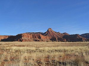
The Vermilion Cliffs near Cane Beds are very tall. They rise more than 1,000 feet (300 meters) above the community. Their highest points are between 6,210 and 6,443 feet (1,893 and 1,964 meters) above sea level. The land in Cane Beds is good for farming. You might see pronghorns and mule deer in the area. The ground around Cane Beds has different types of rocks, like the Moenkopi Formation and Chinle Formation.
Who Lives Here?
The population of Cane Beds has grown over the years.
- 1910: 5 people
- 1920: 42 people
- 1930: 40 people
- 1940: 36 people
- 2010: 448 people
- 2020: 466 people
In 2010, there were 448 people living in Cane Beds. About 231 were male and 217 were female. Many residents were young, with 171 people aged 19 or younger. The average age in Cane Beds was about 29.2 years old.
Most of the people (94.4%) identified as White. There were also people who identified as Native American, Black or African American, and Asian. About 2% of the population identified as Hispanic or Latino.
There were 142 households in the community. Most of these (106) were family households. The average household had about 3.15 people.
Fun Things to Do
Cane Beds is a popular place for hiking. There are many beautiful trails nearby, especially along the border. These trails offer amazing views.
It's important to be careful when hiking. In 2016, a nurse who was hiking alone in Cane Beds fell about 100 feet (30 meters) into a canyon. She was rescued after more than a day. Her hotel owners noticed she was missing and called for help. Mountain and air rescue teams found her. She recovered after three months. This story shows how important it is to be prepared and tell someone where you are going when you hike.
If you want to stay overnight, the Cane Beds Corral offers glamping (glamorous camping) and log cabin rentals. It's a great way to enjoy the outdoors in comfort.
Schools in the Area
Cane Beds is part of two different school districts. Some students attend schools in the Fredonia-Moccasin Unified School District. This district is in nearby Coconino County. Other students go to schools in the Colorado City Unified School District. This district mainly serves the former Short Creek Community.
Years ago, Cane Beds students started going to the Short Creek school district. This was because Cane Beds only had five students, and a school district needed at least eight students to have its own school. So, the districts were combined.
Getting Around and Services
Transportation
The closest small airport is the Colorado City Municipal Airport. For regular flights, the St. George Regional Airport in St. George, Utah, is about an hour away. If you need an international airport, Harry Reid International Airport in Las Vegas is the nearest.
A two-mile stretch of Yellowstone Road in Cane Beds was renamed in 2017. It was named after LaVoy Finicum, a local man. Some residents supported this change to honor his family's long history in the area. This road connects Arizona State Route 389 (SR 389) to Cane Beds.
In 1950, people in the area worked to improve roads and other services. They held a town hall meeting and formed an organization to help the community. Cane Beds Road is part of county road 91. It connects to Interstate 15 (I-15) for about a mile. I-15 is a major highway that links Cane Beds to Utah and Nevada. Arizona State Route 389 also passes close to the town.
Community Services
The Mohave County Sheriff's Office helps keep Cane Beds safe. The Kane County Sheriff's Office in southern Utah also provides support.
For medical care, residents can go to the Creek Valley Health Clinic in Colorado City. Larger hospitals are available at Dixie Regional Medical Center in St. George. For more specialized care, major hospitals are in Salt Lake City and Las Vegas.
The Cox Family Cemetery, also known as the Cane Beds Cemetery, is located in the town. For television, most residents receive local channels from Utah stations. There is also one channel from Phoenix that is owned by Mohave County.
Famous People from Cane Beds
- Benjamin Bistline, a historian
- LaVoy Finicum, a local figure
- Grove Karl Gilbert, a geologist who studied the area
- John D. Lee, an early pioneer who helped settle the area
See also
 In Spanish: Cane Beds (Arizona) para niños
 | George Robert Carruthers |
 | Patricia Bath |
 | Jan Ernst Matzeliger |
 | Alexander Miles |


