Kane County, Utah facts for kids
Quick facts for kids
Kane County
|
|
|---|---|

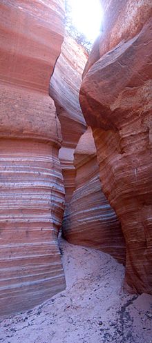
Narrows in Diana's Throne Canyon, also known as the Huntress Slot in vicinity of Mount Carmel Junction.
|
|

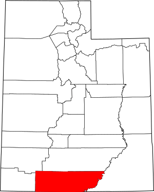
Location within the U.S. state of Utah
|
|
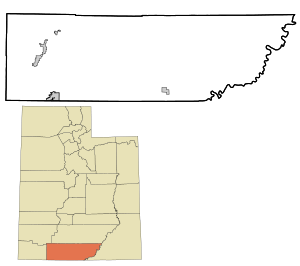
 Utah's location within the U.S. |
|
| Country | |
| State | |
| Founded | January 16, 1864 |
| Named for | Thomas L. Kane |
| Seat | Kanab |
| Largest city | Kanab |
| Area | |
| • Total | 4,109 sq mi (10,640 km2) |
| • Land | 3,990 sq mi (10,300 km2) |
| • Water | 118 sq mi (310 km2) 2.9% |
| Population
(2020)
|
|
| • Total | 7,667 |
| • Density | 1.8659/sq mi (0.72043/km2) |
| Time zone | UTC−7 (Mountain) |
| • Summer (DST) | UTC−6 (MDT) |
| Congressional district | 2nd |

Kane County is a county in the U.S. state of Utah. In 2020, about 7,667 people lived there. The main city and county seat is Kanab.
Contents
History of Kane County
Kane County was created on January 16, 1864. This happened when the old government of the Utah Territory decided to split off parts of Washington County.
The county was named after Colonel Thomas L. Kane. He was a good friend to the Latter Day Saint settlers, also known as Mormons, when they first came to the area in the 1840s and 1850s.
The county's borders changed a few times after that. In 1869, some land went back to Washington County. In 1880, San Juan County was formed from part of Kane County. Then, in 1883, more parts of Kane County were given to Iron and Washington counties.
Exploring Kane County's Geography
Kane County is located in the southern part of Utah. Its southern border touches the state of Arizona. The Colorado River, which forms Lake Powell, makes up its eastern border.
A large part of the county is covered by the Grand Staircase–Escalante National Monument. The land here is very rugged, with deserts, mountains, and tall cliffs. It offers amazing views everywhere you look.
Parts of famous parks like Bryce Canyon National Park and Zion National Park reach into the northern and western areas of Kane County. The eastern side of the county is also part of the Glen Canyon National Recreation Area.
The county covers a total area of about 4,109 square miles. Most of this, about 3,990 square miles, is land. The remaining 118 square miles is water, which is about 2.9% of the total area.
Neighboring Counties
- Washington County - to the west
- Iron County - to the northwest
- Garfield County - to the north
- San Juan County - to the east
- Mohave County, Arizona - to the southwest
- Coconino County, Arizona - to the south
Amazing Protected Areas
- Bryce Canyon National Park (part)
- Coral Pink Sand Dunes State Park
- Dixie National Forest (part)
- Glen Canyon National Recreation Area (part)
- Grand Staircase–Escalante National Monument (part)
- Kodachrome Basin State Park
- Zion National Park (part)
Lakes in Kane County
- Lake Powell (along the eastern border)
- Navajo Lake
People of Kane County
| Historical population | |||
|---|---|---|---|
| Census | Pop. | %± | |
| 1870 | 1,513 | — | |
| 1880 | 3,085 | 103.9% | |
| 1890 | 1,685 | −45.4% | |
| 1900 | 1,811 | 7.5% | |
| 1910 | 1,652 | −8.8% | |
| 1920 | 2,054 | 24.3% | |
| 1930 | 2,235 | 8.8% | |
| 1940 | 2,561 | 14.6% | |
| 1950 | 2,299 | −10.2% | |
| 1960 | 2,667 | 16.0% | |
| 1970 | 2,421 | −9.2% | |
| 1980 | 4,024 | 66.2% | |
| 1990 | 5,169 | 28.5% | |
| 2000 | 6,046 | 17.0% | |
| 2010 | 7,125 | 17.8% | |
| 2020 | 7,667 | 7.6% | |
| US Decennial Census 1790–1960 1900–1990 1990–2000 2010 2020 |
|||
2020 Census Facts
In 2020, the population of Kane County was 7,667 people. This means there were about 1.9 people living in each square mile.
Most people in Kane County are White. There are also smaller groups of Native American, Asian, and African American people. About 4.2% of the people are Hispanic or Latino.
The county has slightly more females than males. The average age of people living in Kane County is about 44.9 years old.
Ancestry in Kane County
The top five ethnic groups in Kane County are:
Communities in Kane County
City
- Kanab (This is the county seat, where the main government offices are.)
Towns
Unincorporated Communities
These are places where people live, but they don't have their own local government like a city or town.
Ghost Towns
These are towns that used to be active but are now mostly empty.
- Johnson
- Paria
Education in Kane County
Kane County has its own school system called the Kane School District.
Utah State University also has a local campus in Kanab, offering college courses.
See also
 In Spanish: Condado de Kane (Utah) para niños
 | Sharif Bey |
 | Hale Woodruff |
 | Richmond Barthé |
 | Purvis Young |


