Kodachrome Basin State Park facts for kids
Quick facts for kids Kodachrome Basin State Park |
|
|---|---|
|
IUCN Category V (Protected Landscape/Seascape)
|
|
 |
|
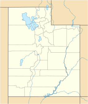
| Location | Kane, Utah, United States |
| Area | 2,240 acres (9.1 km2) |
| Elevation | 5,800 ft (1,800 m) |
| Established | 1962 |
| Named for | Kodachrome film |
| Visitors | 49806 (in 2011) |
| Operator | Utah State Parks |
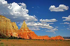
Kodachrome Basin is a beautiful state park in Utah, United States. It sits high up, about 5,800 feet (1,767.8 m) above sea level. The park is about 12 miles (19 km) south of Utah Route 12. It's also about 20 miles (32 km) southeast of Bryce Canyon National Park.
You can reach the park from the north using a paved road from Cannonville. From the south, you can take Road 400. This is a dirt road from the Page, Arizona area to Cannonville. It's usually fine for most cars when the weather is dry. There's also a longer paved route to Tropic from the south, using US-89 and SR-12.
Contents
Discovering Kodachrome Basin's Unique Geology
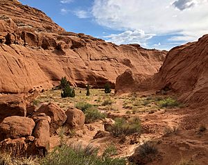
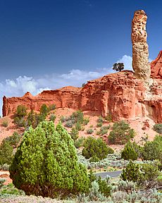
The most interesting part of Kodachrome Basin State Park is its unique rock formations. These are tall, thin sandstone spires and columns called "sand pipes." Scientists believe they might not be found anywhere else on Earth!
How Were the Sand Pipes Formed?
There are different ideas about how these amazing features were created.
One idea is that the area was once like Yellowstone National Park. It might have had hot springs and geysers that bubbled up from the ground. Over time, these hot springs and geysers filled with sand and dirt, which then turned into solid rock. As the softer Entrada Sandstone around these solid cores wore away, the harder sand pipes were left standing tall. There are 67 sand pipes in the park, ranging from two to 52 meters (about 6 to 170 feet) tall.
Another idea suggests that these sandstone spires were formed by "sandstone intrusions." This means that sand was pushed up from below into cracks in the rock. This happened because of huge movements in the Earth's crust, called tectonic activity, which lifted the surrounding plateaus.
Scientists who support this idea point to a few things:
- The sand pipes have a special ring pattern inside them. Each ring can be matched to different rock layers found deeper underground.
- Some of these structures are cut off by layers of rock formed by ancient floods. This suggests the sand pipes were created around the same time as these floods.
- The area also has large amounts of sandstone dikes, which are like walls of sand that pushed up into existing rock.
- The sand pipes don't show signs of chaotic mixing, which you might expect from hot springs. Instead, they look like sand was pushed up smoothly.
- The outside of the sand pipes is very hard, but just a few millimeters inside, the sandstone is quite soft.
Some people argue against the intrusion idea. They say that the original sand was very old and should have been too hard to be pushed up like a liquid. However, there are other rock formations in the area that show sand did become liquid and push up. The hard clay layers that the sand pipes pushed through also suggest that a lot of pressure was needed, which could have come from powerful seismic waves (like from earthquakes).
A Brief History of Kodachrome Basin
Native Americans were likely the first people to explore this area long ago. Later, around the early 1900s, cattle ranchers from Cannonville and Henrieville used the basin to feed their cattle in winter.
In 1948, the National Geographic Society explored and took many photos of the area. Their story appeared in the September 1949 issue of National Geographic magazine. They decided to name the area Kodachrome Flat. They chose this name because the colors of the landscape reminded them of the bright, vivid colors produced by Kodachrome film, a popular type of camera film at the time.
In 1962, the area officially became a state park. For a short time, the name was changed to Chimney Rock State Park because officials worried about using the Kodak company's name. But a few years later, with Kodak's permission, it was happily renamed Kodachrome Basin State Park.
Fun Things to Do at Kodachrome Basin
Kodachrome Basin State Park is a great place for outdoor adventures! Here are some popular activities:
- Photography: The unique rock formations and colorful landscape make it a perfect spot for taking amazing pictures.
- Wildlife Watching: Keep an eye out for local animals and birds that call the park home.
- Camping: The park has 55 campsites, including two larger ones for groups. Showers are available too! You can reserve a spot online at Reserve America.
- Hiking: Explore the park's many trails to see its famous features up close. Popular spots include Chimney Rock, Shakespeare Arch, and Ballerina Geyser.
- Stargazing: Because there's not much city light nearby, the park is fantastic for looking at the stars at night.
- Horseback Riding: You can also go on horseback rides through the park and the wild areas around it.
- Bunkhouse Cabins: If you prefer not to camp, the park also has two bunkhouse cabins where you can stay.
Many visitors also like to visit Grosvenor Arch. This is a cool double arch located about ten miles southeast of the park, within the Grand Staircase–Escalante National Monument.
 | Anna J. Cooper |
 | Mary McLeod Bethune |
 | Lillie Mae Bradford |


