Bryce Canyon National Park facts for kids
Quick facts for kids Bryce Canyon National Park |
|
|---|---|
|
IUCN Category II (National Park)
|
|
 |
|
| Location | Garfield County and Kane County, Utah, United States |
| Nearest city | Tropic, Panguitch |
| Area | 35,835 acres (145.02 km2) |
| Established | February 25, 1928 |
| Visitors | 2,498,075 (in 2024) |
| Governing body | National Park Service |
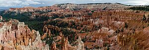
Bryce Canyon National Park is a special place in southwestern Utah, USA. It's famous for its unique rock formations. Even though it's called a "canyon," it's actually a series of huge, bowl-shaped natural areas. These are called amphitheaters. They are carved into the eastern edge of the Paunsaugunt Plateau.
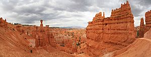
What makes Bryce Canyon so amazing are its "hoodoos." These are tall, thin rock spires that look like giant totem poles. They formed over millions of years from frost weathering (when water freezes and expands in cracks) and erosion by streams. The rocks come in beautiful shades of red, orange, and white. This creates stunning views for everyone who visits.
Bryce Canyon National Park is smaller and higher up than nearby Zion National Park. The edges of Bryce Canyon are between 8,000 and 9,000 feet (2,400 to 2,700 meters) above sea level.
Mormon pioneers first settled this area in the 1850s. The park is named after Ebenezer Bryce, who lived here in 1874. It became a national monument in 1923 and then a full national park in 1928. The park covers about 35,835 acres (145 square kilometers). In 2024, nearly 2.5 million people visited Bryce Canyon.
The park is home to many different plants and animals. It has three main life zones, with various forests and meadows. You can find over 1,000 plant species, 59 types of mammals, and at least 100 kinds of birds here.
Contents
Exploring Bryce Canyon's Unique Landscape
Bryce Canyon National Park covers about 35,835 acres (145 square kilometers). It sits high up in southwestern Utah, between 8,000 and 9,000 feet (2,400 to 2,700 meters) above sea level. It is about 50 miles (80 km) northeast of Zion National Park. Bryce Canyon is also about 1,000 feet (300 meters) higher than Zion.
Where is Bryce Canyon Located?
The park is part of a huge area called the Colorado Plateau in North America. It sits right on the edge of the Paunsaugunt Plateau. The word Paunsaugunt comes from the Paiute language and means "home of the beaver." When you visit, you stand on this plateau and look down into a large valley. This valley holds the Paria River, whose name means "muddy or elk water" in Paiute.
How Bryce Canyon's Amphitheaters Formed
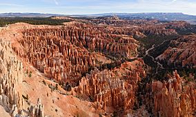
Bryce Canyon is not a typical canyon carved by a single river. Instead, it was shaped by a process called headward erosion. This means that water slowly wore away the soft rock from the edges of the plateau. Over time, this created huge, natural, bowl-shaped areas called amphitheaters.
These amphitheaters are filled with colorful rock pillars known as hoodoos. Some of these hoodoos can be as tall as 200 feet (60 meters)! There are many amphitheaters stretching over 20 miles (32 km) from north to south in the park. The biggest one is Bryce Amphitheater. It is 12 miles (19 km) long, 3 miles (5 km) wide, and 800 feet (240 meters) deep. You can see similar hoodoos at Cedar Breaks National Monument, about 25 miles (40 km) to the west.
High Points and Scenic Views
The highest spot in the park is Rainbow Point, at 9,105 feet (2,775 meters). It's at the end of an 18-mile (29 km) scenic drive. From here, you can see amazing sights like the Aquarius Plateau, the Henry Mountains, and the Vermilion Cliffs. The lowest part of the park is Yellow Creek, in the northeast, at 6,620 feet (2,018 meters).
Bryce Canyon's Weather and Climate
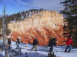
Bryce Canyon has a continental climate. This means it has warm, dry summers and cold winters. The weather here is generally cooler and gets more rain and snow than Zion National Park.
Temperatures and Precipitation
Each year, Bryce Canyon receives about 15 to 18 inches (380 to 460 mm) of precipitation. Temperatures change a lot throughout the year. In January, the average low is about 9°F (-13°C). In July, the average high is around 83°F (28°C). However, temperatures can be much more extreme, from -30°F (-34°C) to 97°F (36°C). The highest temperature ever recorded was 98°F (37°C) in July 2002. The lowest was -28°F (-33°C) in December 1972.
| Climate data for Bryce Canyon National Park Headquarters, Utah, 1991–2020 normals, extremes 1959–present | |||||||||||||
|---|---|---|---|---|---|---|---|---|---|---|---|---|---|
| Month | Jan | Feb | Mar | Apr | May | Jun | Jul | Aug | Sep | Oct | Nov | Dec | Year |
| Record high °F (°C) | 59 (15) |
64 (18) |
67 (19) |
75 (24) |
85 (29) |
95 (35) |
98 (37) |
90 (32) |
89 (32) |
80 (27) |
68 (20) |
60 (16) |
98 (37) |
| Mean maximum °F (°C) | 48.9 (9.4) |
50.7 (10.4) |
59.0 (15.0) |
67.6 (19.8) |
75.7 (24.3) |
84.1 (28.9) |
87.8 (31.0) |
84.6 (29.2) |
79.6 (26.4) |
70.8 (21.6) |
58.4 (14.7) |
49.3 (9.6) |
88.4 (31.3) |
| Mean daily maximum °F (°C) | 36.9 (2.7) |
38.8 (3.8) |
45.8 (7.7) |
53.5 (11.9) |
63.1 (17.3) |
75.1 (23.9) |
80.0 (26.7) |
77.5 (25.3) |
70.1 (21.2) |
58.2 (14.6) |
45.8 (7.7) |
36.8 (2.7) |
56.8 (13.8) |
| Daily mean °F (°C) | 26.9 (−2.8) |
28.6 (−1.9) |
34.5 (1.4) |
41.2 (5.1) |
49.9 (9.9) |
59.8 (15.4) |
66.0 (18.9) |
63.7 (17.6) |
55.9 (13.3) |
45.0 (7.2) |
34.3 (1.3) |
26.9 (−2.8) |
44.4 (6.9) |
| Mean daily minimum °F (°C) | 17.0 (−8.3) |
18.4 (−7.6) |
23.3 (−4.8) |
28.9 (−1.7) |
36.6 (2.6) |
44.6 (7.0) |
52.1 (11.2) |
50.0 (10.0) |
41.6 (5.3) |
31.9 (−0.1) |
22.8 (−5.1) |
17.0 (−8.3) |
32.0 (0.0) |
| Mean minimum °F (°C) | −0.4 (−18.0) |
1.1 (−17.2) |
7.1 (−13.8) |
15.5 (−9.2) |
23.1 (−4.9) |
31.0 (−0.6) |
40.8 (4.9) |
39.7 (4.3) |
27.8 (−2.3) |
18.4 (−7.6) |
4.7 (−15.2) |
−1.0 (−18.3) |
−4.7 (−20.4) |
| Record low °F (°C) | −26 (−32) |
−26 (−32) |
−11 (−24) |
−3 (−19) |
13 (−11) |
21 (−6) |
28 (−2) |
23 (−5) |
16 (−9) |
0 (−18) |
−12 (−24) |
−23 (−31) |
−26 (−32) |
| Average precipitation inches (mm) | 1.91 (49) |
1.70 (43) |
1.27 (32) |
0.77 (20) |
0.91 (23) |
0.47 (12) |
1.55 (39) |
1.94 (49) |
1.78 (45) |
1.73 (44) |
1.28 (33) |
1.34 (34) |
16.65 (423) |
| Average snowfall inches (cm) | 19.8 (50) |
18.1 (46) |
13.2 (34) |
5.9 (15) |
1.5 (3.8) |
0.2 (0.51) |
0.0 (0.0) |
0.0 (0.0) |
0.0 (0.0) |
3.0 (7.6) |
9.7 (25) |
15.3 (39) |
86.7 (220) |
| Average precipitation days (≥ 0.01 in) | 6.3 | 7.6 | 6.2 | 5.7 | 5.5 | 3.2 | 8.8 | 10.2 | 7.0 | 5.3 | 4.7 | 6.2 | 76.7 |
| Average snowy days (≥ 0.1 in) | 6.3 | 7.2 | 5.5 | 3.3 | 1.2 | 0.1 | 0.0 | 0.0 | 0.0 | 1.3 | 3.4 | 5.7 | 34.0 |
| Mean monthly sunshine hours | 217.0 | 226.0 | 248.0 | 300.0 | 341.0 | 360.0 | 341.0 | 310.0 | 300.0 | 279.0 | 210.0 | 186.0 | 3,318 |
| Mean daily sunshine hours | 7 | 8 | 8 | 10 | 11 | 12 | 11 | 10 | 10 | 9 | 7 | 6 | 9 |
| Mean daily daylight hours | 9.9 | 10.8 | 12.0 | 13.2 | 14.2 | 14.7 | 14.5 | 13.6 | 12.4 | 11.2 | 10.2 | 9.6 | 12.2 |
| Percent possible sunshine | 71 | 74 | 67 | 76 | 77 | 82 | 76 | 74 | 81 | 80 | 69 | 63 | 74 |
| Average ultraviolet index | 2 | 4 | 6 | 8 | 10 | 11 | 11 | 10 | 8 | 5 | 3 | 2 | 7 |
| Source 1: NOAA | |||||||||||||
| Source 2: Weather Atlas (sun data) | |||||||||||||
History of Bryce Canyon National Park
Early Native American Life
Not much is known about the very first people who lived in the Bryce Canyon area. However, scientists have found signs that people lived on the Paunsaugunt Plateau for at least 10,000 years. Artifacts from ancient cultures like the Basketmakers and Anasazi have been found nearby.
Around the time these older cultures left, the Paiute Native Americans moved into the area. They hunted animals and gathered plants for most of their food. The Paiute people had a special story about the hoodoos. They believed these rock formations were "Legend People" who were turned to stone by the trickster Coyote because of their bad actions. One Paiute elder said his people called the hoodoos Anka-ku-was-a-wits, which means "red painted faces."
European American Exploration and Settlement
In the late 1700s and early 1800s, the first European Americans explored this region. Mormon scouts visited in the 1850s to see if the land was good for farming and raising animals. A big scientific trip was led by U.S. Army Major John Wesley Powell in 1872. His team mapped the area and used many Paiute names for places.
Small groups of Mormon pioneers then tried to settle near the Paria River. In 1874, The Church of Jesus Christ of Latter-day Saints sent a Scottish immigrant named Ebenezer Bryce and his wife, Mary, to live there. Ebenezer Bryce was a carpenter. The Bryce family settled right below the main group of hoodoos, which is now called Bryce Amphitheater. Ebenezer Bryce grazed his cattle inside what is now the park. He famously said the amphitheaters were "a heck of a place to lose a cow!" He built a road and a canal to help his farm. Soon, other settlers started calling the area "Bryce's Canyon," and the name stuck.
After some tough times with drought and too many animals grazing, most settlers, including the Bryce family, left the area. Ebenezer Bryce moved his family to Arizona in 1880.
Becoming a National Park
People started to learn about the beautiful sights of Bryce Canyon through magazine articles in 1916. More articles in 1918 helped even more people become interested. Soon, places to stay and tour services were set up for visitors. The Union Pacific Railroad also wanted to bring tourists to southwestern Utah.
However, people became worried about the damage being done to the canyon from too many animals grazing, logging, and uncontrolled visitors. So, efforts began to protect the area. In 1923, President Warren G. Harding made Bryce Canyon a national monument.
A road was built that same year to help people reach the viewpoints. Between 1924 and 1925, the Bryce Canyon Lodge was built using local wood and stone.
In 1924, members of the United States Congress began working to make Bryce Canyon a national park. After four years of transferring land to the government, Bryce Canyon officially became a national park on February 25, 1928.
Later, in 1931 and 1942, more land was added to the park. This brought its total size to 35,835 acres (145 square kilometers). The scenic drive, Rim Road, was finished in 1935.
Bryce Canyon After 1950
The USS Bryce Canyon, a supply ship, was named after the park. It served in the U.S. Pacific Fleet from 1950 to 1981.
In 1956, Bryce Canyon got its first superintendent, and the park began to manage itself. The Bryce Canyon Natural History Association was created in 1961. This group helps support educational and scientific activities in the park.
The historic Bryce Canyon Lodge was recognized as a National Historic Landmark in 1987. It is a great example of park architecture from the 1920s.
To help with more visitors and traffic, the park started a shuttle bus system in the summer of 2000. The main road, Rim Road, was rebuilt between 2002 and 2004. In 2019, Bryce Canyon was named a Dark Sky Park. This means it has an exceptionally dark night sky, perfect for stargazing.
The Geology of Bryce Canyon's Rocks
The rocks you see in Bryce Canyon were formed over a very long time. This happened from the end of the Cretaceous period to the middle of the Cenozoic era. The area was once covered by warm, shallow seas. Over millions of years, layers of sand, mud, and other materials were laid down. These layers eventually hardened into different types of sedimentary rock.
How Hoodoos and Arches are Formed
The land here was lifted up twice by huge geological forces. The first uplift, called the Laramide orogeny, happened about 70 to 50 million years ago. This event helped create the Rocky Mountains. Later, about 16 million years ago, the Colorado Plateaus were lifted. This caused the land to crack into large blocks, separated by faults.
These cracks, called vertical joints, were weak spots. Water and ice slowly wore them away. The softer pink rocks of the Claron Formation eroded into the amazing freestanding hoodoo pillars. The harder white rocks formed larger, more solid structures. You can also see natural arches formed by this same process.
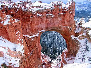
The Colors of Bryce Canyon
The rocks in Bryce Canyon are famous for their vibrant colors.
- The bright orange colors come from a mineral called hematite (iron oxide).
- Yellows are from limonite (another iron-containing mineral).
- Purple colors come from pyrolusite (a manganese mineral).
Plants and Animals of Bryce Canyon
Bryce Canyon National Park is home to a wide variety of living things. More than 1,000 different plant species grow here. The park also has 59 types of mammals, over 45 kinds of butterflies and moths, and more than 100 species of birds.
Life Zones and Their Inhabitants
The park has three main "life zones," which depend on how high up the land is:
- Highest Areas: Here, you'll find Douglas fir trees, Blue spruce, and quaking aspen. Animals like mule deer, elk, grouse, squirrels, and Chipmunks live in these forests.
- Mid-Elevations: These areas are mostly covered by Ponderosa pine forests. You can also see greenleaf manzanita and Rocky Mountain juniper trees.
- Lowest Elevations: These parts of the park are drier. They have Colorado pinyon and Utah juniper trees. Birds like pinyon jays and Clark's nutcrackers eat the pinyon seeds and help the trees spread.
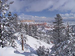
Wildlife and Conservation
Besides the animals mentioned, you might spot ringtails, antelope, and even mountain lions. Birds like peregrine falcons, ospreys, jays, and hummingbirds fly through the skies. The park also has 11 types of reptiles, including the Great Basin rattlesnake and short-horned lizard. Four kinds of amphibians, like the tiger salamander, also live here.
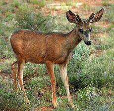
Bryce Canyon is an important home for three species listed under the Endangered Species Act. These are the Utah prairie dog, the California condor, and the southwestern willow flycatcher. The Utah prairie dog, a threatened species, has been brought back to the park. Bryce Canyon now protects the largest population of these prairie dogs.
Cryptobiotic Soil: A Tiny Ecosystem
You might also see black, lumpy patches of cryptobiotic soil in the park. This is a living crust made of lichens, algae, fungi, and cyanobacteria. These tiny organisms work together to slow down erosion, add important nutrients like nitrogen to the soil, and help the ground hold moisture. It's a very important part of the park's ecosystem!
Fun Activities at Bryce Canyon
Bryce Canyon National Park offers many exciting ways to explore its beauty.
Hiking Adventures
There are eight marked and maintained day hikes for you to enjoy:
- Easy to Moderate Hikes:
- Mossy Cave (about 1 hour, located off State Route 12 northwest of Tropic)
- Rim Trail (5–6 hours, you can start anywhere along the rim)
- Bristlecone Loop (about 1 hour, at Rainbow Point)
- Queens Garden (1–2 hours, starting from Sunrise Point)
- Moderate Hikes:
- Navajo Loop (1–2 hours, starting from Sunset Point)
- Tower Bridge (2–3 hours, north of Sunrise Point)
- Strenuous Hikes:
- Fairyland Loop (4–5 hours, from Fairyland Point)
- Peekaboo Loop (3–4 hours, from Bryce Point)
Many of these trails connect, so you can plan longer and more challenging hikes if you want!
Overnight Backpacking Trails
For those who love longer adventures, the park has two trails for overnight trips:
- The 9-mile (14 km) Riggs Spring Loop Trail
- The 23-mile (37 km) Under-the-Rim Trail
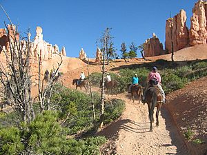
Amazing Views and Stargazing
On clear days, you can see for miles! From Yovimpa and Rainbow points, you might spot Navajo Mountain and the Kaibab Plateau, which are 90 miles (145 km) away in Arizona. You can even see the Black Mesas of eastern Arizona and western New Mexico, about 160 miles (257 km) away.
Bryce Canyon has one of the darkest night skies in North America. It has a 7.4 magnitude night sky, meaning you can see about 7,500 stars! Park rangers often host special events for stargazing and teach about astronomy and nocturnal animals. The Bryce Canyon Astronomy Festival, usually in June, brings thousands of visitors. An asteroid (49272) was even named after the park!
Camping in the Park
The park has two campgrounds: North Campground and Sunset Campground. Loop A in North Campground is open all year. Other loops and Sunset Campground are open from late spring to early autumn.
See also
 In Spanish: Parque nacional del Cañón Bryce para niños
 | John T. Biggers |
 | Thomas Blackshear |
 | Mark Bradford |
 | Beverly Buchanan |


