Paunsaugunt Plateau facts for kids

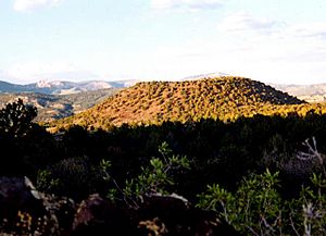
The Paunsaugunt Plateau (say "PAWN-suh-gant") is a large, flat area of land that has been cut into by rivers and erosion. It rises high above the land around it, reaching between 7,000 and 9,300 feet (about 2,100 to 2,800 meters) tall. This plateau is located in southwestern Utah in the United States.
You can find the Paunsaugunt Plateau in northern Kane County and southwestern Garfield County. It is about 10 miles (16 kilometers) wide and stretches south for about 25 miles (40 kilometers) from the Sevier Plateau. At its southern end, it stops at the beautiful Pink Cliffs.
Contents
Rivers and Natural Areas
The Paunsaugunt Plateau is home to several important rivers and natural areas. The East Fork Sevier River flows north across the plateau. It eventually joins the main Sevier River, which runs in a valley along the plateau's western side.
Bryce Canyon National Park
The eastern side of the plateau is deeply cut by erosion, creating amazing landscapes. This area is drained by the Paria River, which flows into the Colorado River system. This eastern part of the plateau is protected as Bryce Canyon National Park. It's famous for its unique rock formations.
Other Protected Lands
A part of the Great Basin Divide runs along the plateau. This divide separates water that flows to the Pacific Ocean from water that stays in the Great Basin. Much of the plateau is also part of Dixie National Forest, a large protected forest area.
Weather and Roads
The plateau gets a lot of snow, about 200 inches (500 centimeters) each year! It also experiences about 200 days of freezing and thawing cycles. Highway 12, which is a special All-American Road, crosses the Paunsaugunt Plateau. This road offers amazing views of the landscape.
How the Plateau Was Formed
The Paunsaugunt Plateau was created by powerful natural forces. About 10 to 20 million years ago, a huge uplift happened in the larger Colorado Plateau area. This uplift pushed the land upwards, forming the plateau.
Unique Rock Formations
As the land lifted, cracks called joints formed along the sides of the plateau. Over millions of years, water, ice, and wind have eroded these cracks. This erosion is especially noticeable on the eastern side, inside Bryce Canyon National Park.
The erosion has carved out strange and beautiful rock formations called hoodoos. These tall, thin spires of rock are the most famous feature of Bryce Canyon National Park. They make the park look like an alien landscape!
 | James Van Der Zee |
 | Alma Thomas |
 | Ellis Wilson |
 | Margaret Taylor-Burroughs |


