Pink Cliffs facts for kids

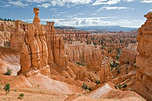
The Pink Cliffs are a group of amazing rock formations in southwestern Utah, United States. They are found in Garfield, Iron, and Kane counties, on a high area called the Colorado Plateau. Even though they are called "cliffs," they aren't just one big cliff. Instead, they are many different rock shapes that are all part of the same huge rock layer.
Contents
What Are the Pink Cliffs?

The Pink Cliffs are made of many unique rock shapes. You can see many of these formations in places like Bryce Canyon National Park and Cedar Breaks National Monument. Other parts of the cliffs are found within the Dixie National Forest.
How the Pink Cliffs Got Their Color
These cliffs get their name from their beautiful pink and red colors. They are made of a type of rock called limestone from the Claron Formation. This rock layer is the very top part of a huge series of rock layers called the Grand Staircase. Imagine a giant staircase going down from Utah all the way to the Grand Canyon in Arizona! The Pink Cliffs are the highest step on this amazing staircase. A geologist named Clarence Dutton gave the Pink Cliffs and the other layers of the Grand Staircase their names in the 1870s.
Where to Find the Pink Cliffs
Many people think the Pink Cliffs are only in Bryce Canyon National Park because it's a very popular place to see them. However, these cliffs actually stretch much further! They form a wide "U" shape across three different counties.
The westernmost part of the cliffs is on the edge of the Markagunt Plateau, mostly inside Cedar Breaks National Monument. The easternmost part is on the edge of the Paunsaugunt Plateau, mainly within Bryce Canyon National Park. From Cedar Breaks in the west, the cliffs curve south around the Markagunt Plateau. They run near Navajo Lake in northeastern Kane County. After being split by the Long Valley and the valley of Kanab Creek, the cliffs wrap around the southern and southeastern edges of the Paunsaugunt Plateau. They then extend north through and beyond Bryce Canyon National Park.
See also
 In Spanish: Acantilados Rosados para niños
 | James Van Der Zee |
 | Alma Thomas |
 | Ellis Wilson |
 | Margaret Taylor-Burroughs |

