
Long Valley (Kane County, Utah) facts for kids
Quick facts for kids Long Valley |
|
|---|---|

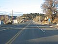
Glendale, Utah at south Long Valley
|
|
| Dimensions | |
| Length | 13 mi (21 km) SSW x NNE |
| Geography | |

Location in Utah
|
|
| Country | United States |
| Communities | Glendale and (Long Valley Junction) |
| Range coordinates | 37°22′44″N 112°34′24″W / 37.37889°N 112.57333°W |
The Long Valley in Utah is a 13-mile (21 km) long valley. It is found in western Kane County. This valley is special because it's where the sources of rivers flowing north, south, and southwest are located. It sits in the western part of the High Plateaus section of the Colorado Plateau. This High Plateaus area also reaches into northern Arizona, near the Grand Canyon.
Long Valley is next to the Kolob Terrace on its east side. The Markagunt Plateau and Paunsaugunt Plateaus, which are covered in forests, are to its northwest and northeast. To the east, there's a mountain area that acts as a water divide. East of this divide, the Kanab Creek flows south through a narrow valley. This creek eventually joins the Colorado River. The northern part of Long Valley and the two plateaus are part of the Dixie National Forest.
The town of Glendale, Utah is at the south end of the valley, right on the East Fork Virgin River. U.S. Route 89 (US&8209;89) follows this river valley through the southern half of Long Valley. The East Fork river turns east, and US&8209;89 leaves the valley to the north-northeast at Long Valley Junction. This junction is on a water divide, where the north-flowing Sevier River begins.
The East Fork Virgin River flows south from near the middle of the valley. Just south of Glendale, it turns southwest. Its source is in the northeast part of the valley, near the Long Valley Junction area.
Contents
What is Long Valley Like?
Long Valley is mostly a river valley shaped by the East Fork Virgin River. In the northwest part of the valley, there's another valley running alongside it. This parallel valley collects streams that are about 3-mile (4.8 km) long. These streams flow southeast from the water divide on the south-southeast side of the Markagunt Plateau. On the other side of that divide, Swains Creek flows northeast.
Three Rivers Start Here
The eastern edge of Long Valley has some smaller mountain peaks and another water divide. East of this divide is the Alton Amphitheater. From here, Kanab Creek flows south all the way to the Colorado River in the Grand Canyon. Kanab Creek starts on the southwest side of the Paunsaugunt Plateau. In this same area, the Upper Kanab Creek flows northeast and joins the north-flowing East Sevier River.
West of where Kanab Creek starts, you'll find the source of the East Fork Virgin River. This is in the area around Long Valley Junction. The junction is just northwest of Alton and the Alton Amphitheater. The East Fork Virgin River flows south through Long Valley, then southwest to meet the main Virgin River. The Virgin River then flows into Lake Mead.
Getting Around Long Valley
US&8209;89 is the main road to get into Long Valley. You can reach it from Mount Carmel or Orderville, which are about 4 miles (6.4 km) southwest of Glendale.
Another paved road enters the valley and Glendale from the east. This road is called "Lower Kanab Creek to Alton Rd." It starts from US&8209;89, east of Kanab, and goes north, then northeast into Long Valley. It passes through the western parts of the Grand Staircase–Escalante National Monument.
Alton Road comes into the northeast part of Long Valley from Alton, Utah. It also connects to the Alton Amphitheater, which is to the east. The Alton Amphitheater is part of the Pink Cliffs and is where the south-flowing Kanab Creek begins.
In the northwest part of the valley, you'll find Stout Canyon Road. This paved road goes through Stout Canyon and connects to Utah State Route 14 on the water divide (the Great Basin Divide), west of Long Valley Junction. The southern end of Stout Canyon Road connects to US&8209;89 in the middle of Long Valley. Another road branches off Stout Canyon Road to the west and northwest. It leads to Swains Creek Road, which follows a northeast-flowing stream at the northeast edge of Kolob Terrace and the southern edge of the Markagunt Plateau.
There's also a partially paved road that leaves US&8209;89 in the center of the valley. It goes to Black Mountain, which is 7,777 feet (2,370 m) high. From there, it continues southeast on an unpaved path to Buck Knoll, which is 6,738 feet (2,054 m) high. This whole trip is about 9 miles from the center of Long Valley.
Images for kids
-
Glendale, Utah at south Long Valley
